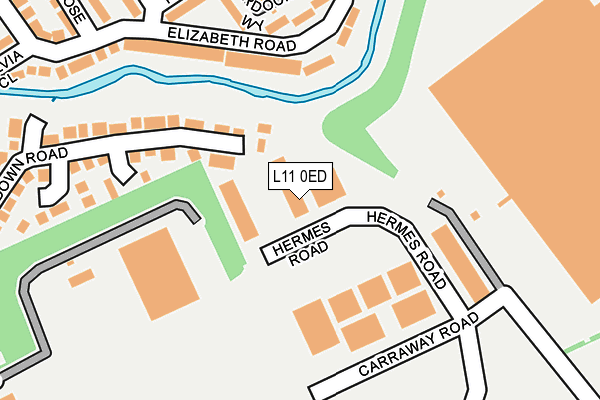
L11 0ED is located in the Fazakerley East electoral ward, within the metropolitan district of Liverpool and the English Parliamentary constituency of Liverpool, Walton. The Sub Integrated Care Board (ICB) Location is NHS Cheshire and Merseyside ICB - 99A and the police force is Merseyside. This postcode has been in use since October 1984.


GetTheData
Source: OS OpenMap – Local (Ordnance Survey)
Source: OS VectorMap District (Ordnance Survey)
Licence: Open Government Licence (requires attribution)
| Easting | 339999 |
| Northing | 396755 |
| Latitude | 53.464119 |
| Longitude | -2.905236 |
GetTheData
Source: Open Postcode Geo
Licence: Open Government Licence
| Country | England |
| Postcode District | L11 |
➜ See where L11 is on a map ➜ Where is Liverpool? | |
GetTheData
Source: Land Registry Price Paid Data
Licence: Open Government Licence
Elevation or altitude of L11 0ED as distance above sea level:
| Metres | Feet | |
|---|---|---|
| Elevation | 20m | 66ft |
Elevation is measured from the approximate centre of the postcode, to the nearest point on an OS contour line from OS Terrain 50, which has contour spacing of ten vertical metres.
➜ How high above sea level am I? Find the elevation of your current position using your device's GPS.
GetTheData
Source: Open Postcode Elevation
Licence: Open Government Licence
| Ward | Fazakerley East |
| Constituency | Liverpool, Walton |
GetTheData
Source: ONS Postcode Database
Licence: Open Government Licence
| Pamela Close (Elizabeth Road) | Field Lane Estate | 255m |
| Gilmoss Park & Ride (East Lancashire Road) | Gillmoss | 382m |
| Gilmoss Park & Ride (East Lancs Road) | Gillmoss | 398m |
| Back Gillmoss Lane (East Lancashire Road) | Croxteth | 449m |
| Gillmoss Park & Ride (East Lancashire Road) | Croxteth | 461m |
| Fazakerley Station | 2.2km |
| Kirkby Station | 2.5km |
| Aintree Station | 3.6km |
GetTheData
Source: NaPTAN
Licence: Open Government Licence
| Median download speed | 17.3Mbps |
| Average download speed | 17.4Mbps |
| Maximum download speed | 52.17Mbps |
| Median upload speed | 2.6Mbps |
| Average upload speed | 3.2Mbps |
| Maximum upload speed | 9.96Mbps |
GetTheData
Source: Ofcom
Licence: Ofcom Terms of Use (requires attribution)
GetTheData
Source: ONS Postcode Database
Licence: Open Government Licence


➜ Get more ratings from the Food Standards Agency
GetTheData
Source: Food Standards Agency
Licence: FSA terms & conditions
| Last Collection | |||
|---|---|---|---|
| Location | Mon-Fri | Sat | Distance |
| Amanda Road | 16:00 | 12:00 | 706m |
| Copplehouse Lane | 16:00 | 12:00 | 708m |
| Longmoor Lane Post Office | 17:00 | 12:00 | 1,315m |
GetTheData
Source: Dracos
Licence: Creative Commons Attribution-ShareAlike
The below table lists the International Territorial Level (ITL) codes (formerly Nomenclature of Territorial Units for Statistics (NUTS) codes) and Local Administrative Units (LAU) codes for L11 0ED:
| ITL 1 Code | Name |
|---|---|
| TLD | North West (England) |
| ITL 2 Code | Name |
| TLD7 | Merseyside |
| ITL 3 Code | Name |
| TLD72 | Liverpool |
| LAU 1 Code | Name |
| E08000012 | Liverpool |
GetTheData
Source: ONS Postcode Directory
Licence: Open Government Licence
The below table lists the Census Output Area (OA), Lower Layer Super Output Area (LSOA), and Middle Layer Super Output Area (MSOA) for L11 0ED:
| Code | Name | |
|---|---|---|
| OA | E00033756 | |
| LSOA | E01006663 | Liverpool 004C |
| MSOA | E02001350 | Liverpool 004 |
GetTheData
Source: ONS Postcode Directory
Licence: Open Government Licence
| L10 4XL | Elizabeth Road | 193m |
| L10 4XP | Elizabeth Road | 208m |
| L10 4YD | Dawn Walk | 223m |
| L10 4UN | Carland Close | 224m |
| L10 4XR | Elizabeth Road | 228m |
| L10 4YB | Jean Walk | 243m |
| L10 4US | Longdown Road | 263m |
| L10 4UY | Travanson Close | 274m |
| L10 4YA | Lydia Walk | 276m |
| L10 4YF | Amanda Road | 298m |
GetTheData
Source: Open Postcode Geo; Land Registry Price Paid Data
Licence: Open Government Licence