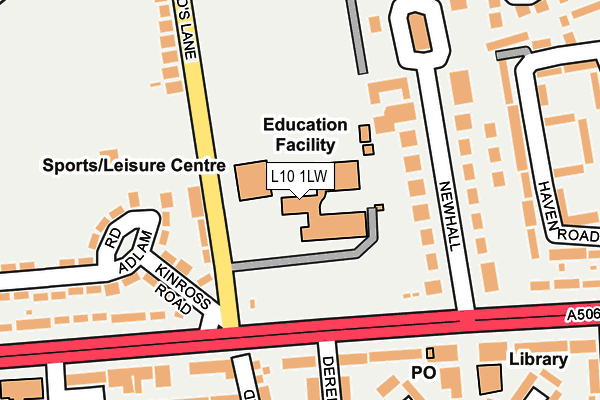
L10 1LW is located in the Fazakerley East electoral ward, within the metropolitan district of Liverpool and the English Parliamentary constituency of Liverpool, Walton. The Sub Integrated Care Board (ICB) Location is NHS Cheshire and Merseyside ICB - 99A and the police force is Merseyside. This postcode has been in use since January 1980.


GetTheData
Source: OS OpenMap – Local (Ordnance Survey)
Source: OS VectorMap District (Ordnance Survey)
Licence: Open Government Licence (requires attribution)
| Easting | 338653 |
| Northing | 397497 |
| Latitude | 53.470633 |
| Longitude | -2.925653 |
GetTheData
Source: Open Postcode Geo
Licence: Open Government Licence
| Country | England |
| Postcode District | L10 |
➜ See where L10 is on a map ➜ Where is Liverpool? | |
GetTheData
Source: Land Registry Price Paid Data
Licence: Open Government Licence
Elevation or altitude of L10 1LW as distance above sea level:
| Metres | Feet | |
|---|---|---|
| Elevation | 20m | 66ft |
Elevation is measured from the approximate centre of the postcode, to the nearest point on an OS contour line from OS Terrain 50, which has contour spacing of ten vertical metres.
➜ How high above sea level am I? Find the elevation of your current position using your device's GPS.
GetTheData
Source: Open Postcode Elevation
Licence: Open Government Licence
| Ward | Fazakerley East |
| Constituency | Liverpool, Walton |
GetTheData
Source: ONS Postcode Database
Licence: Open Government Licence
| Sherwoods Lane (Longmoor Lane) | Fazakerley | 119m |
| Swainson Road (Longmoor Lane) | Fazakerley | 171m |
| Dereham Crescent (Longmoor Lane) | Fazakerley | 190m |
| Haven Road (Longmoor Lane) | Fazakerley | 217m |
| Twigden Close (Sherwoods Lane) | Fazakerley | 339m |
| Fazakerley Station | 0.8km |
| Aintree Station | 2.1km |
| Kirkby Station | 2.3km |
GetTheData
Source: NaPTAN
Licence: Open Government Licence
GetTheData
Source: ONS Postcode Database
Licence: Open Government Licence


➜ Get more ratings from the Food Standards Agency
GetTheData
Source: Food Standards Agency
Licence: FSA terms & conditions
| Last Collection | |||
|---|---|---|---|
| Location | Mon-Fri | Sat | Distance |
| Longmoor Lane Post Office | 17:00 | 12:00 | 238m |
| Sherwood Lane | 16:00 | 12:00 | 464m |
| Copplehouse Lane | 16:00 | 12:00 | 835m |
GetTheData
Source: Dracos
Licence: Creative Commons Attribution-ShareAlike
The below table lists the International Territorial Level (ITL) codes (formerly Nomenclature of Territorial Units for Statistics (NUTS) codes) and Local Administrative Units (LAU) codes for L10 1LW:
| ITL 1 Code | Name |
|---|---|
| TLD | North West (England) |
| ITL 2 Code | Name |
| TLD7 | Merseyside |
| ITL 3 Code | Name |
| TLD72 | Liverpool |
| LAU 1 Code | Name |
| E08000012 | Liverpool |
GetTheData
Source: ONS Postcode Directory
Licence: Open Government Licence
The below table lists the Census Output Area (OA), Lower Layer Super Output Area (LSOA), and Middle Layer Super Output Area (MSOA) for L10 1LW:
| Code | Name | |
|---|---|---|
| OA | E00033718 | |
| LSOA | E01006653 | Liverpool 001B |
| MSOA | E02001347 | Liverpool 001 |
GetTheData
Source: ONS Postcode Directory
Licence: Open Government Licence
| L10 1LD | New Hall | 119m |
| L10 1LH | Kinross Road | 165m |
| L10 1LN | Sherwoods Lane | 172m |
| L10 7LN | Longmoor Lane | 185m |
| L10 7LA | Dereham Crescent | 230m |
| L10 1LX | Haven Road | 232m |
| L10 1LU | Haven Road | 233m |
| L10 7LE | Formosa Drive | 236m |
| L10 9LD | Greystone Road | 241m |
| L10 9LE | Greystone Road | 266m |
GetTheData
Source: Open Postcode Geo; Land Registry Price Paid Data
Licence: Open Government Licence