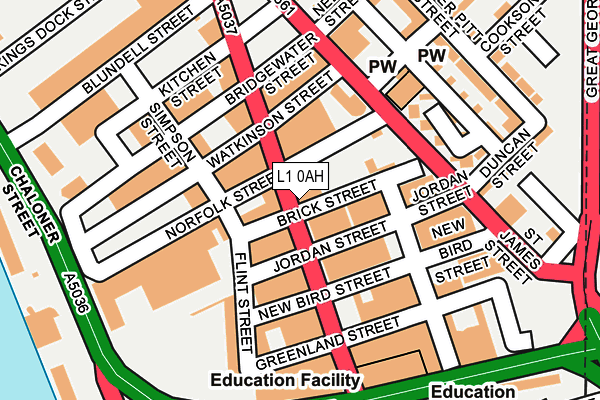
L1 0AH is located in the City Centre South electoral ward, within the metropolitan district of Liverpool and the English Parliamentary constituency of Liverpool, Riverside. The Sub Integrated Care Board (ICB) Location is NHS Cheshire and Merseyside ICB - 99A and the police force is Merseyside. This postcode has been in use since January 1980.


GetTheData
Source: OS OpenMap – Local (Ordnance Survey)
Source: OS VectorMap District (Ordnance Survey)
Licence: Open Government Licence (requires attribution)
| Easting | 334922 |
| Northing | 389174 |
| Latitude | 53.395385 |
| Longitude | -2.980129 |
GetTheData
Source: Open Postcode Geo
Licence: Open Government Licence
| Country | England |
| Postcode District | L1 |
➜ See where L1 is on a map ➜ Where is Liverpool? | |
GetTheData
Source: Land Registry Price Paid Data
Licence: Open Government Licence
Elevation or altitude of L1 0AH as distance above sea level:
| Metres | Feet | |
|---|---|---|
| Elevation | 20m | 66ft |
Elevation is measured from the approximate centre of the postcode, to the nearest point on an OS contour line from OS Terrain 50, which has contour spacing of ten vertical metres.
➜ How high above sea level am I? Find the elevation of your current position using your device's GPS.
GetTheData
Source: Open Postcode Elevation
Licence: Open Government Licence
| Ward | City Centre South |
| Constituency | Liverpool, Riverside |
GetTheData
Source: ONS Postcode Database
Licence: Open Government Licence
| Greenland Street | Liverpool | 59m |
| Norfolk Street (St James Street) | Liverpool | 144m |
| Hardy Street (St James Street) | Liverpool | 199m |
| Bridgewater Street | Liverpool | 205m |
| Parliament Street (Sefton Street) | Toxteth | 281m |
| Liverpool Central Station | 1km |
| Liverpool James Street Station | 1.3km |
| Liverpool Lime Street Station | 1.3km |
GetTheData
Source: NaPTAN
Licence: Open Government Licence
| Percentage of properties with Next Generation Access | 0.0% |
| Percentage of properties with Superfast Broadband | 0.0% |
| Percentage of properties with Ultrafast Broadband | 0.0% |
| Percentage of properties with Full Fibre Broadband | 0.0% |
Superfast Broadband is between 30Mbps and 300Mbps
Ultrafast Broadband is > 300Mbps
| Percentage of properties unable to receive 2Mbps | 0.0% |
| Percentage of properties unable to receive 5Mbps | 0.0% |
| Percentage of properties unable to receive 10Mbps | 0.0% |
| Percentage of properties unable to receive 30Mbps | 100.0% |
GetTheData
Source: Ofcom
Licence: Ofcom Terms of Use (requires attribution)
GetTheData
Source: ONS Postcode Database
Licence: Open Government Licence


➜ Get more ratings from the Food Standards Agency
GetTheData
Source: Food Standards Agency
Licence: FSA terms & conditions
| Last Collection | |||
|---|---|---|---|
| Location | Mon-Fri | Sat | Distance |
| St James Street | 18:15 | 12:00 | 213m |
| Wapping Dock | 18:30 | 12:00 | 385m |
| Windsor Street | 16:00 | 12:00 | 482m |
GetTheData
Source: Dracos
Licence: Creative Commons Attribution-ShareAlike
The below table lists the International Territorial Level (ITL) codes (formerly Nomenclature of Territorial Units for Statistics (NUTS) codes) and Local Administrative Units (LAU) codes for L1 0AH:
| ITL 1 Code | Name |
|---|---|
| TLD | North West (England) |
| ITL 2 Code | Name |
| TLD7 | Merseyside |
| ITL 3 Code | Name |
| TLD72 | Liverpool |
| LAU 1 Code | Name |
| E08000012 | Liverpool |
GetTheData
Source: ONS Postcode Directory
Licence: Open Government Licence
The below table lists the Census Output Area (OA), Lower Layer Super Output Area (LSOA), and Middle Layer Super Output Area (MSOA) for L1 0AH:
| Code | Name | |
|---|---|---|
| OA | E00033024 | |
| LSOA | E01006515 | Liverpool 037B |
| MSOA | E02001383 | Liverpool 037 |
GetTheData
Source: ONS Postcode Directory
Licence: Open Government Licence
| L1 0DN | New Bird Street | 133m |
| L1 0AB | St James Street | 159m |
| L1 0AR | Bridgewater Street | 178m |
| L8 5RZ | Plaza Boulevard | 213m |
| L8 5SR | Plaza Boulevard | 213m |
| L8 5ST | Plaza Boulevard | 213m |
| L8 5RW | Parliament Street | 215m |
| L1 7AG | Great George Place | 226m |
| L8 5RE | Stanhope Street | 243m |
| L8 5RS | Plaza Boulevard | 245m |
GetTheData
Source: Open Postcode Geo; Land Registry Price Paid Data
Licence: Open Government Licence