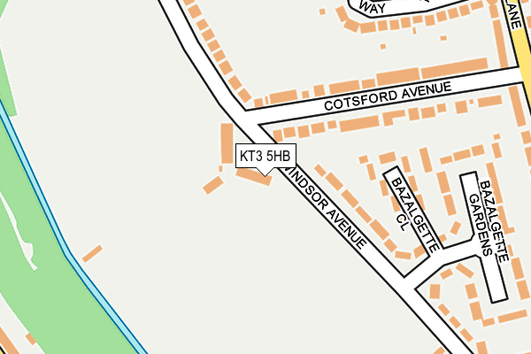
KT3 5HB is located in the Green Lane & St James electoral ward, within the London borough of Kingston upon Thames and the English Parliamentary constituency of Kingston and Surbiton. The Sub Integrated Care Board (ICB) Location is NHS South West London ICB - 36L and the police force is Metropolitan Police. This postcode has been in use since January 1980.


GetTheData
Source: OS OpenMap – Local (Ordnance Survey)
Source: OS VectorMap District (Ordnance Survey)
Licence: Open Government Licence (requires attribution)
| Easting | 520366 |
| Northing | 167646 |
| Latitude | 51.395091 |
| Longitude | -0.271265 |
GetTheData
Source: Open Postcode Geo
Licence: Open Government Licence
| Country | England |
| Postcode District | KT3 |
➜ See where KT3 is on a map ➜ Where is New Malden? | |
GetTheData
Source: Land Registry Price Paid Data
Licence: Open Government Licence
Elevation or altitude of KT3 5HB as distance above sea level:
| Metres | Feet | |
|---|---|---|
| Elevation | 20m | 66ft |
Elevation is measured from the approximate centre of the postcode, to the nearest point on an OS contour line from OS Terrain 50, which has contour spacing of ten vertical metres.
➜ How high above sea level am I? Find the elevation of your current position using your device's GPS.
GetTheData
Source: Open Postcode Elevation
Licence: Open Government Licence
| Ward | Green Lane & St James |
| Constituency | Kingston And Surbiton |
GetTheData
Source: ONS Postcode Database
Licence: Open Government Licence
| Nelson Road South Lane | New Malden | 401m |
| Nelson Road South Lane | New Malden | 433m |
| Pembroke Avenue (Surbiton Hill Park) | Berrylands | 512m |
| Pembroke Avenue (Surbiton Hill Park) | Berrylands | 547m |
| The Roystons (Raeburn Avenue) | Berrylands | 596m |
| Berrylands Station | 0.8km |
| Malden Manor Station | 1.3km |
| New Malden Station | 1.5km |
GetTheData
Source: NaPTAN
Licence: Open Government Licence
GetTheData
Source: ONS Postcode Database
Licence: Open Government Licence


➜ Get more ratings from the Food Standards Agency
GetTheData
Source: Food Standards Agency
Licence: FSA terms & conditions
| Last Collection | |||
|---|---|---|---|
| Location | Mon-Fri | Sat | Distance |
| Green Lane | 17:45 | 12:15 | 284m |
| South Lane Post Office | 17:30 | 12:00 | 338m |
| Grand Avenue | 17:45 | 12:00 | 392m |
GetTheData
Source: Dracos
Licence: Creative Commons Attribution-ShareAlike
The below table lists the International Territorial Level (ITL) codes (formerly Nomenclature of Territorial Units for Statistics (NUTS) codes) and Local Administrative Units (LAU) codes for KT3 5HB:
| ITL 1 Code | Name |
|---|---|
| TLI | London |
| ITL 2 Code | Name |
| TLI6 | Outer London - South |
| ITL 3 Code | Name |
| TLI63 | Merton, Kingston upon Thames and Sutton |
| LAU 1 Code | Name |
| E09000021 | Kingston upon Thames |
GetTheData
Source: ONS Postcode Directory
Licence: Open Government Licence
The below table lists the Census Output Area (OA), Lower Layer Super Output Area (LSOA), and Middle Layer Super Output Area (MSOA) for KT3 5HB:
| Code | Name | |
|---|---|---|
| OA | E00015028 | |
| LSOA | E01002986 | Kingston upon Thames 008E |
| MSOA | E02000605 | Kingston upon Thames 008 |
GetTheData
Source: ONS Postcode Directory
Licence: Open Government Licence
| KT3 5EZ | Windsor Avenue | 104m |
| KT3 5HG | Bazalgette Close | 145m |
| KT3 5HE | Windsor Avenue | 177m |
| KT3 5EU | Cotsford Avenue | 193m |
| KT3 5EY | Windsor Avenue | 194m |
| KT3 5BT | Groveland Way | 261m |
| KT3 5BU | Green Lane | 266m |
| KT3 5HF | Bazalgette Gardens | 288m |
| KT3 5BS | Hawkhurst Way | 300m |
| KT3 5BX | Green Lane | 308m |
GetTheData
Source: Open Postcode Geo; Land Registry Price Paid Data
Licence: Open Government Licence