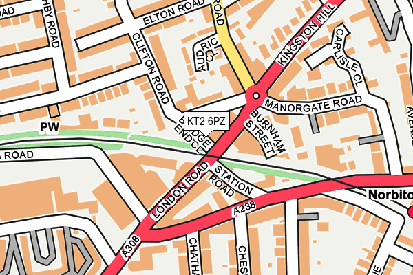
KT2 6PZ is located in the Kingston Gate electoral ward, within the London borough of Kingston upon Thames and the English Parliamentary constituency of Richmond Park. The Sub Integrated Care Board (ICB) Location is NHS South West London ICB - 36L and the police force is Metropolitan Police. This postcode has been in use since June 2003.


GetTheData
Source: OS OpenMap – Local (Ordnance Survey)
Source: OS VectorMap District (Ordnance Survey)
Licence: Open Government Licence (requires attribution)
| Easting | 519109 |
| Northing | 169662 |
| Latitude | 51.413476 |
| Longitude | -0.288649 |
GetTheData
Source: Open Postcode Geo
Licence: Open Government Licence
| Country | England |
| Postcode District | KT2 |
➜ See where KT2 is on a map ➜ Where is Kingston upon Thames? | |
GetTheData
Source: Land Registry Price Paid Data
Licence: Open Government Licence
Elevation or altitude of KT2 6PZ as distance above sea level:
| Metres | Feet | |
|---|---|---|
| Elevation | 10m | 33ft |
Elevation is measured from the approximate centre of the postcode, to the nearest point on an OS contour line from OS Terrain 50, which has contour spacing of ten vertical metres.
➜ How high above sea level am I? Find the elevation of your current position using your device's GPS.
GetTheData
Source: Open Postcode Elevation
Licence: Open Government Licence
| Ward | Kingston Gate |
| Constituency | Richmond Park |
GetTheData
Source: ONS Postcode Database
Licence: Open Government Licence
| Manor Gate Road (London Road) | Norbiton | 68m |
| Gordon Road (Kt2) | Norbiton | 110m |
| Audric Close (Park Road) | Norbiton | 116m |
| Gordon Road (Kt2) (Coombe Road) | Norbiton | 148m |
| Station Road (Kt2) (Coombe Road) | Norbiton | 157m |
| Norbiton Station | 0.3km |
| Kingston Station | 0.9km |
| Hampton Wick Station | 1.7km |
GetTheData
Source: NaPTAN
Licence: Open Government Licence
| Percentage of properties with Next Generation Access | 100.0% |
| Percentage of properties with Superfast Broadband | 100.0% |
| Percentage of properties with Ultrafast Broadband | 100.0% |
| Percentage of properties with Full Fibre Broadband | 0.0% |
Superfast Broadband is between 30Mbps and 300Mbps
Ultrafast Broadband is > 300Mbps
| Percentage of properties unable to receive 2Mbps | 0.0% |
| Percentage of properties unable to receive 5Mbps | 0.0% |
| Percentage of properties unable to receive 10Mbps | 0.0% |
| Percentage of properties unable to receive 30Mbps | 0.0% |
GetTheData
Source: Ofcom
Licence: Ofcom Terms of Use (requires attribution)
GetTheData
Source: ONS Postcode Database
Licence: Open Government Licence


➜ Get more ratings from the Food Standards Agency
GetTheData
Source: Food Standards Agency
Licence: FSA terms & conditions
| Last Collection | |||
|---|---|---|---|
| Location | Mon-Fri | Sat | Distance |
| Park Road | 17:30 | 12:00 | 69m |
| Birkenhead Avenue | 17:30 | 12:00 | 234m |
| Dagmar Road | 17:30 | 12:00 | 288m |
GetTheData
Source: Dracos
Licence: Creative Commons Attribution-ShareAlike
The below table lists the International Territorial Level (ITL) codes (formerly Nomenclature of Territorial Units for Statistics (NUTS) codes) and Local Administrative Units (LAU) codes for KT2 6PZ:
| ITL 1 Code | Name |
|---|---|
| TLI | London |
| ITL 2 Code | Name |
| TLI6 | Outer London - South |
| ITL 3 Code | Name |
| TLI63 | Merton, Kingston upon Thames and Sutton |
| LAU 1 Code | Name |
| E09000021 | Kingston upon Thames |
GetTheData
Source: ONS Postcode Directory
Licence: Open Government Licence
The below table lists the Census Output Area (OA), Lower Layer Super Output Area (LSOA), and Middle Layer Super Output Area (MSOA) for KT2 6PZ:
| Code | Name | |
|---|---|---|
| OA | E00014771 | |
| LSOA | E01002935 | Kingston upon Thames 003A |
| MSOA | E02000600 | Kingston upon Thames 003 |
GetTheData
Source: ONS Postcode Directory
Licence: Open Government Licence
| KT2 6PW | Clifton Road | 41m |
| KT2 6PA | London Road | 60m |
| KT2 6PT | London Road | 67m |
| KT2 6PH | Clifton Road | 82m |
| KT2 6BX | Park Road | 100m |
| KT2 6QR | Burnham Street | 104m |
| KT2 6QW | London Road | 107m |
| KT2 6BP | Audric Close | 108m |
| KT2 7AA | Station Road | 115m |
| KT2 6BU | Orchard Cottages | 120m |
GetTheData
Source: Open Postcode Geo; Land Registry Price Paid Data
Licence: Open Government Licence