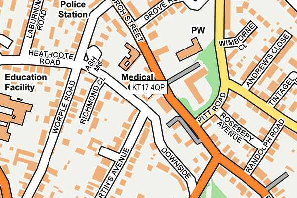
KT17 4QP lies on Church Street in Epsom. KT17 4QP is located in the College electoral ward, within the local authority district of Epsom and Ewell and the English Parliamentary constituency of Epsom and Ewell. The Sub Integrated Care Board (ICB) Location is NHS Surrey Heartlands ICB - 92A and the police force is Surrey. This postcode has been in use since October 1984.


GetTheData
Source: OS OpenMap – Local (Ordnance Survey)
Source: OS VectorMap District (Ordnance Survey)
Licence: Open Government Licence (requires attribution)
| Easting | 521311 |
| Northing | 160425 |
| Latitude | 51.329992 |
| Longitude | -0.260173 |
GetTheData
Source: Open Postcode Geo
Licence: Open Government Licence
| Street | Church Street |
| Town/City | Epsom |
| Country | England |
| Postcode District | KT17 |
➜ See where KT17 is on a map ➜ Where is Epsom? | |
GetTheData
Source: Land Registry Price Paid Data
Licence: Open Government Licence
Elevation or altitude of KT17 4QP as distance above sea level:
| Metres | Feet | |
|---|---|---|
| Elevation | 60m | 197ft |
Elevation is measured from the approximate centre of the postcode, to the nearest point on an OS contour line from OS Terrain 50, which has contour spacing of ten vertical metres.
➜ How high above sea level am I? Find the elevation of your current position using your device's GPS.
GetTheData
Source: Open Postcode Elevation
Licence: Open Government Licence
| Ward | College |
| Constituency | Epsom And Ewell |
GetTheData
Source: ONS Postcode Database
Licence: Open Government Licence
| Pitt Road (Church Street) | Epsom | 95m |
| Chartwell Place (Smalls Hill Road) | Ewell | 283m |
| Epsom Fire Station (Church Street Epsom) | Ewell | 293m |
| Fire Station (Church Street) | Epsom | 308m |
| Heathcote Road (Ashley Road) | Epsom | 356m |
| Epsom Station | 0.8km |
| Epsom Downs Station | 1.6km |
| Ewell East Station | 2.1km |
GetTheData
Source: NaPTAN
Licence: Open Government Licence
GetTheData
Source: ONS Postcode Database
Licence: Open Government Licence


➜ Get more ratings from the Food Standards Agency
GetTheData
Source: Food Standards Agency
Licence: FSA terms & conditions
| Last Collection | |||
|---|---|---|---|
| Location | Mon-Fri | Sat | Distance |
| St Martins Avenue | 17:30 | 12:30 | 158m |
| Heathcote Road | 17:45 | 12:30 | 295m |
| Downs Avenue | 17:00 | 12:30 | 315m |
GetTheData
Source: Dracos
Licence: Creative Commons Attribution-ShareAlike
The below table lists the International Territorial Level (ITL) codes (formerly Nomenclature of Territorial Units for Statistics (NUTS) codes) and Local Administrative Units (LAU) codes for KT17 4QP:
| ITL 1 Code | Name |
|---|---|
| TLJ | South East (England) |
| ITL 2 Code | Name |
| TLJ2 | Surrey, East and West Sussex |
| ITL 3 Code | Name |
| TLJ26 | East Surrey |
| LAU 1 Code | Name |
| E07000208 | Epsom and Ewell |
GetTheData
Source: ONS Postcode Directory
Licence: Open Government Licence
The below table lists the Census Output Area (OA), Lower Layer Super Output Area (LSOA), and Middle Layer Super Output Area (MSOA) for KT17 4QP:
| Code | Name | |
|---|---|---|
| OA | E00155107 | |
| LSOA | E01030412 | Epsom and Ewell 008C |
| MSOA | E02006342 | Epsom and Ewell 008 |
GetTheData
Source: ONS Postcode Directory
Licence: Open Government Licence
| KT18 5EZ | Giles Mead | 53m |
| KT17 4PY | Pitt Place | 89m |
| KT17 4QG | Downs Lodge Court | 90m |
| KT18 5HZ | St Martins Avenue | 92m |
| KT17 4QB | Church Street | 102m |
| KT18 5EY | Richmond Close | 113m |
| KT18 5ET | Downside | 114m |
| KT17 4PX | Church Street | 128m |
| KT17 4QD | Church Street | 152m |
| KT17 4ET | Pitt Road | 152m |
GetTheData
Source: Open Postcode Geo; Land Registry Price Paid Data
Licence: Open Government Licence