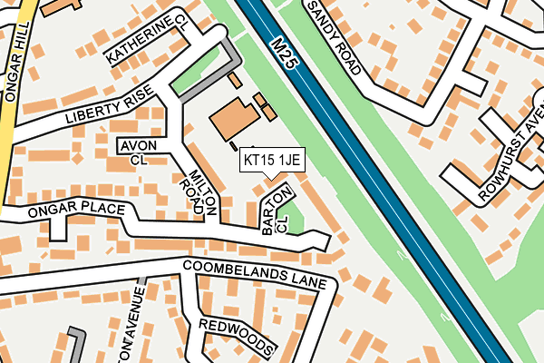
KT15 1JE lies on Barton Close in Addlestone. KT15 1JE is located in the Woodham & Rowtown electoral ward, within the local authority district of Runnymede and the English Parliamentary constituency of Runnymede and Weybridge. The Sub Integrated Care Board (ICB) Location is NHS Surrey Heartlands ICB - 92A and the police force is Surrey. This postcode has been in use since January 1980.


GetTheData
Source: OS OpenMap – Local (Ordnance Survey)
Source: OS VectorMap District (Ordnance Survey)
Licence: Open Government Licence (requires attribution)
| Easting | 504360 |
| Northing | 163801 |
| Latitude | 51.363698 |
| Longitude | -0.502390 |
GetTheData
Source: Open Postcode Geo
Licence: Open Government Licence
| Street | Barton Close |
| Town/City | Addlestone |
| Country | England |
| Postcode District | KT15 |
➜ See where KT15 is on a map ➜ Where is Row Town? | |
GetTheData
Source: Land Registry Price Paid Data
Licence: Open Government Licence
Elevation or altitude of KT15 1JE as distance above sea level:
| Metres | Feet | |
|---|---|---|
| Elevation | 20m | 66ft |
Elevation is measured from the approximate centre of the postcode, to the nearest point on an OS contour line from OS Terrain 50, which has contour spacing of ten vertical metres.
➜ How high above sea level am I? Find the elevation of your current position using your device's GPS.
GetTheData
Source: Open Postcode Elevation
Licence: Open Government Licence
| Ward | Woodham & Rowtown |
| Constituency | Runnymede And Weybridge |
GetTheData
Source: ONS Postcode Database
Licence: Open Government Licence
| Dale Close (Orchard Way) | Addlestone | 280m |
| Dale Close (Orchard Way) | Addlestone | 298m |
| Ongar Close (Ongar Hill) | Row Town | 325m |
| Coombelands Ongar Hill (Ongar Hill) | Row Town | 328m |
| Ongar Close (Ongar Hill) | Row Town | 331m |
| Addlestone Station | 1.6km |
| Byfleet & New Haw Station | 2.1km |
| Chertsey Station | 2.6km |
GetTheData
Source: NaPTAN
Licence: Open Government Licence
| Percentage of properties with Next Generation Access | 100.0% |
| Percentage of properties with Superfast Broadband | 100.0% |
| Percentage of properties with Ultrafast Broadband | 100.0% |
| Percentage of properties with Full Fibre Broadband | 0.0% |
Superfast Broadband is between 30Mbps and 300Mbps
Ultrafast Broadband is > 300Mbps
| Median download speed | 74.4Mbps |
| Average download speed | 84.2Mbps |
| Maximum download speed | 200.00Mbps |
| Median upload speed | 19.4Mbps |
| Average upload speed | 18.7Mbps |
| Maximum upload speed | 20.00Mbps |
| Percentage of properties unable to receive 2Mbps | 0.0% |
| Percentage of properties unable to receive 5Mbps | 0.0% |
| Percentage of properties unable to receive 10Mbps | 0.0% |
| Percentage of properties unable to receive 30Mbps | 0.0% |
GetTheData
Source: Ofcom
Licence: Ofcom Terms of Use (requires attribution)
Estimated total energy consumption in KT15 1JE by fuel type, 2015.
| Consumption (kWh) | 204,523 |
|---|---|
| Meter count | 14 |
| Mean (kWh/meter) | 14,609 |
| Median (kWh/meter) | 14,964 |
| Consumption (kWh) | 51,073 |
|---|---|
| Meter count | 13 |
| Mean (kWh/meter) | 3,929 |
| Median (kWh/meter) | 3,572 |
GetTheData
Source: Postcode level gas estimates: 2015 (experimental)
Source: Postcode level electricity estimates: 2015 (experimental)
Licence: Open Government Licence
GetTheData
Source: ONS Postcode Database
Licence: Open Government Licence


➜ Get more ratings from the Food Standards Agency
GetTheData
Source: Food Standards Agency
Licence: FSA terms & conditions
| Last Collection | |||
|---|---|---|---|
| Location | Mon-Fri | Sat | Distance |
| Ongar Parade Post Office | 17:15 | 12:00 | 326m |
| Liberty Lane | 17:15 | 11:30 | 499m |
| Addlestone Church | 17:15 | 11:30 | 513m |
GetTheData
Source: Dracos
Licence: Creative Commons Attribution-ShareAlike
The below table lists the International Territorial Level (ITL) codes (formerly Nomenclature of Territorial Units for Statistics (NUTS) codes) and Local Administrative Units (LAU) codes for KT15 1JE:
| ITL 1 Code | Name |
|---|---|
| TLJ | South East (England) |
| ITL 2 Code | Name |
| TLJ2 | Surrey, East and West Sussex |
| ITL 3 Code | Name |
| TLJ25 | West Surrey |
| LAU 1 Code | Name |
| E07000212 | Runnymede |
GetTheData
Source: ONS Postcode Directory
Licence: Open Government Licence
The below table lists the Census Output Area (OA), Lower Layer Super Output Area (LSOA), and Middle Layer Super Output Area (MSOA) for KT15 1JE:
| Code | Name | |
|---|---|---|
| OA | E00156367 | |
| LSOA | E01030660 | Runnymede 009C |
| MSOA | E02006401 | Runnymede 009 |
GetTheData
Source: ONS Postcode Directory
Licence: Open Government Licence
| KT15 1JB | Milton Road | 77m |
| KT15 1JG | Ongar Place | 85m |
| KT15 1JN | Redwoods | 163m |
| KT15 1JD | Avon Close | 165m |
| KT15 1JF | Ongar Place | 181m |
| KT15 1NT | Liberty Rise | 182m |
| KT15 1JA | Sandy Road | 187m |
| KT15 1HZ | Sandy Road | 216m |
| KT15 1NU | Liberty Rise | 221m |
| KT15 1LL | Wriotsley Way | 230m |
GetTheData
Source: Open Postcode Geo; Land Registry Price Paid Data
Licence: Open Government Licence