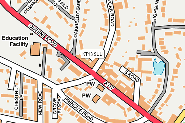
KT13 9UU is located in the Weybridge Riverside electoral ward, within the local authority district of Elmbridge and the English Parliamentary constituency of Runnymede and Weybridge. The Sub Integrated Care Board (ICB) Location is NHS Surrey Heartlands ICB - 92A and the police force is Surrey. This postcode has been in use since June 1996.


GetTheData
Source: OS OpenMap – Local (Ordnance Survey)
Source: OS VectorMap District (Ordnance Survey)
Licence: Open Government Licence (requires attribution)
| Easting | 508218 |
| Northing | 164455 |
| Latitude | 51.368854 |
| Longitude | -0.446777 |
GetTheData
Source: Open Postcode Geo
Licence: Open Government Licence
| Country | England |
| Postcode District | KT13 |
➜ See where KT13 is on a map ➜ Where is Weybridge? | |
GetTheData
Source: Land Registry Price Paid Data
Licence: Open Government Licence
Elevation or altitude of KT13 9UU as distance above sea level:
| Metres | Feet | |
|---|---|---|
| Elevation | 30m | 98ft |
Elevation is measured from the approximate centre of the postcode, to the nearest point on an OS contour line from OS Terrain 50, which has contour spacing of ten vertical metres.
➜ How high above sea level am I? Find the elevation of your current position using your device's GPS.
GetTheData
Source: Open Postcode Elevation
Licence: Open Government Licence
| Ward | Weybridge Riverside |
| Constituency | Runnymede And Weybridge |
GetTheData
Source: ONS Postcode Database
Licence: Open Government Licence
| York Road (Queens Road) | Weybridge | 29m |
| York Road (Queens Road) | Weybridge | 66m |
| Haines Bridge (Queens Road) | Weybridge | 262m |
| Haines Bridge (Queens Road) | Weybridge | 276m |
| Vaillant Road (Oatlands Drive) | Weybridge | 310m |
| Weybridge Station | 1.1km |
| Walton-on-Thames Station | 2.3km |
| Addlestone Station | 2.7km |
GetTheData
Source: NaPTAN
Licence: Open Government Licence
Estimated total energy consumption in KT13 9UU by fuel type, 2015.
| Consumption (kWh) | 34,756 |
|---|---|
| Meter count | 6 |
| Mean (kWh/meter) | 5,793 |
| Median (kWh/meter) | 5,492 |
GetTheData
Source: Postcode level gas estimates: 2015 (experimental)
Source: Postcode level electricity estimates: 2015 (experimental)
Licence: Open Government Licence
GetTheData
Source: ONS Postcode Database
Licence: Open Government Licence


➜ Get more ratings from the Food Standards Agency
GetTheData
Source: Food Standards Agency
Licence: FSA terms & conditions
| Last Collection | |||
|---|---|---|---|
| Location | Mon-Fri | Sat | Distance |
| Queens Road Post Office | 18:30 | 12:15 | 28m |
| Princes Road | 17:30 | 12:30 | 238m |
| York Road | 17:15 | 12:00 | 331m |
GetTheData
Source: Dracos
Licence: Creative Commons Attribution-ShareAlike
The below table lists the International Territorial Level (ITL) codes (formerly Nomenclature of Territorial Units for Statistics (NUTS) codes) and Local Administrative Units (LAU) codes for KT13 9UU:
| ITL 1 Code | Name |
|---|---|
| TLJ | South East (England) |
| ITL 2 Code | Name |
| TLJ2 | Surrey, East and West Sussex |
| ITL 3 Code | Name |
| TLJ25 | West Surrey |
| LAU 1 Code | Name |
| E07000207 | Elmbridge |
GetTheData
Source: ONS Postcode Directory
Licence: Open Government Licence
The below table lists the Census Output Area (OA), Lower Layer Super Output Area (LSOA), and Middle Layer Super Output Area (MSOA) for KT13 9UU:
| Code | Name | |
|---|---|---|
| OA | E00154935 | |
| LSOA | E01030375 | Elmbridge 012E |
| MSOA | E02006328 | Elmbridge 012 |
GetTheData
Source: ONS Postcode Directory
Licence: Open Government Licence
| KT13 9EL | York Road | 0m |
| KT13 9UF | Queens Road | 35m |
| KT13 9UG | Queens Road | 35m |
| KT13 9XE | Queens Road | 61m |
| KT13 9DT | York Road | 61m |
| KT13 9DR | York Road | 84m |
| KT13 9DS | York Road | 84m |
| KT13 9DX | York Road | 87m |
| KT13 9UQ | Queens Road | 98m |
| KT13 9XF | Queens Road | 109m |
GetTheData
Source: Open Postcode Geo; Land Registry Price Paid Data
Licence: Open Government Licence