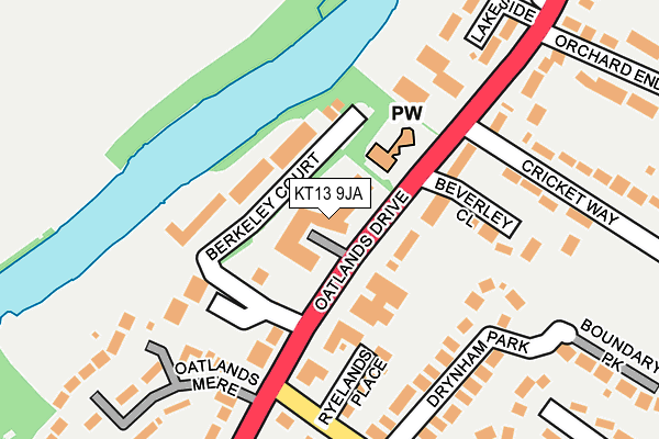
KT13 9JA lies on Oatlands Drive in Weybridge. KT13 9JA is located in the Oatlands and Burwood Park electoral ward, within the local authority district of Elmbridge and the English Parliamentary constituency of Runnymede and Weybridge. The Sub Integrated Care Board (ICB) Location is NHS Surrey Heartlands ICB - 92A and the police force is Surrey. This postcode has been in use since January 1980.


GetTheData
Source: OS OpenMap – Local (Ordnance Survey)
Source: OS VectorMap District (Ordnance Survey)
Licence: Open Government Licence (requires attribution)
| Easting | 509079 |
| Northing | 165614 |
| Latitude | 51.379108 |
| Longitude | -0.434079 |
GetTheData
Source: Open Postcode Geo
Licence: Open Government Licence
| Street | Oatlands Drive |
| Town/City | Weybridge |
| Country | England |
| Postcode District | KT13 |
➜ See where KT13 is on a map ➜ Where is Weybridge? | |
GetTheData
Source: Land Registry Price Paid Data
Licence: Open Government Licence
Elevation or altitude of KT13 9JA as distance above sea level:
| Metres | Feet | |
|---|---|---|
| Elevation | 20m | 66ft |
Elevation is measured from the approximate centre of the postcode, to the nearest point on an OS contour line from OS Terrain 50, which has contour spacing of ten vertical metres.
➜ How high above sea level am I? Find the elevation of your current position using your device's GPS.
GetTheData
Source: Open Postcode Elevation
Licence: Open Government Licence
| Ward | Oatlands And Burwood Park |
| Constituency | Runnymede And Weybridge |
GetTheData
Source: ONS Postcode Database
Licence: Open Government Licence
| Beverley Close (Oatlands Drive) | Walton-on-thames | 82m |
| Beverley Close (Oatlands Drive) | Walton-on-thames | 127m |
| Oatlands Chase (Oatlands Drive) | Weybridge | 215m |
| Oatlands Chase (Oatlands Drive) | Weybridge | 283m |
| The Mount (Oatlands Drive) | Walton-on-thames | 415m |
| Walton-on-Thames Station | 1.5km |
| Shepperton Station | 2.2km |
| Weybridge Station | 2.5km |
GetTheData
Source: NaPTAN
Licence: Open Government Licence
| Percentage of properties with Next Generation Access | 100.0% |
| Percentage of properties with Superfast Broadband | 100.0% |
| Percentage of properties with Ultrafast Broadband | 100.0% |
| Percentage of properties with Full Fibre Broadband | 0.0% |
Superfast Broadband is between 30Mbps and 300Mbps
Ultrafast Broadband is > 300Mbps
| Median download speed | 40.0Mbps |
| Average download speed | 41.5Mbps |
| Maximum download speed | 80.00Mbps |
| Median upload speed | 9.9Mbps |
| Average upload speed | 9.0Mbps |
| Maximum upload speed | 20.00Mbps |
| Percentage of properties unable to receive 2Mbps | 0.0% |
| Percentage of properties unable to receive 5Mbps | 0.0% |
| Percentage of properties unable to receive 10Mbps | 0.0% |
| Percentage of properties unable to receive 30Mbps | 0.0% |
GetTheData
Source: Ofcom
Licence: Ofcom Terms of Use (requires attribution)
GetTheData
Source: ONS Postcode Database
Licence: Open Government Licence


➜ Get more ratings from the Food Standards Agency
GetTheData
Source: Food Standards Agency
Licence: FSA terms & conditions
| Last Collection | |||
|---|---|---|---|
| Location | Mon-Fri | Sat | Distance |
| Berkeley Court | 17:15 | 12:15 | 109m |
| Castle Road | 17:15 | 12:15 | 407m |
| Silverdale Road | 16:45 | 12:00 | 609m |
GetTheData
Source: Dracos
Licence: Creative Commons Attribution-ShareAlike
The below table lists the International Territorial Level (ITL) codes (formerly Nomenclature of Territorial Units for Statistics (NUTS) codes) and Local Administrative Units (LAU) codes for KT13 9JA:
| ITL 1 Code | Name |
|---|---|
| TLJ | South East (England) |
| ITL 2 Code | Name |
| TLJ2 | Surrey, East and West Sussex |
| ITL 3 Code | Name |
| TLJ25 | West Surrey |
| LAU 1 Code | Name |
| E07000207 | Elmbridge |
GetTheData
Source: ONS Postcode Directory
Licence: Open Government Licence
The below table lists the Census Output Area (OA), Lower Layer Super Output Area (LSOA), and Middle Layer Super Output Area (MSOA) for KT13 9JA:
| Code | Name | |
|---|---|---|
| OA | E00170427 | |
| LSOA | E01030339 | Elmbridge 011B |
| MSOA | E02006327 | Elmbridge 011 |
GetTheData
Source: ONS Postcode Directory
Licence: Open Government Licence
| KT13 9HU | Berkeley Court | 81m |
| KT13 9HY | Berkeley Court | 81m |
| KT13 9LN | Oatlands Drive | 83m |
| KT13 9LD | Admiral Close | 93m |
| KT13 9HT | Oatlands Drive | 117m |
| KT13 9HX | Berkeley Court | 125m |
| KT13 9RD | Oatlands Chase | 133m |
| KT13 9AF | Mallards Reach | 142m |
| KT13 9SH | Ryelands Place | 143m |
| KT13 9LW | Beverley Close | 146m |
GetTheData
Source: Open Postcode Geo; Land Registry Price Paid Data
Licence: Open Government Licence