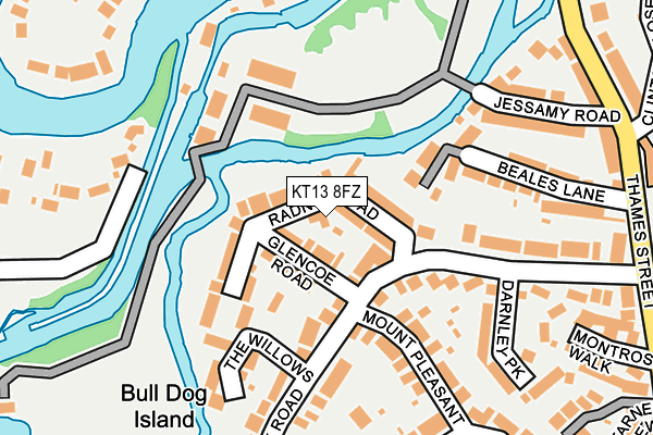
KT13 8FZ is located in the Weybridge Riverside electoral ward, within the local authority district of Elmbridge and the English Parliamentary constituency of Runnymede and Weybridge. The Sub Integrated Care Board (ICB) Location is NHS Surrey Heartlands ICB - 92A and the police force is Surrey. This postcode has been in use since April 2017.


GetTheData
Source: OS OpenMap – Local (Ordnance Survey)
Source: OS VectorMap District (Ordnance Survey)
Licence: Open Government Licence (requires attribution)
| Easting | 507358 |
| Northing | 165402 |
| Latitude | 51.377529 |
| Longitude | -0.458841 |
GetTheData
Source: Open Postcode Geo
Licence: Open Government Licence
| Country | England |
| Postcode District | KT13 |
| ➜ KT13 open data dashboard ➜ See where KT13 is on a map | |
GetTheData
Source: Land Registry Price Paid Data
Licence: Open Government Licence
| Ward | Weybridge Riverside |
| Constituency | Runnymede And Weybridge |
GetTheData
Source: ONS Postcode Database
Licence: Open Government Licence
| January 2024 | Burglary | On or near Wey Road | 465m |
| January 2024 | Burglary | On or near Wey Road | 465m |
| November 2023 | Vehicle crime | On or near Wey Road | 465m |
| ➜ Get more crime data in our Crime section | |||
GetTheData
Source: data.police.uk
Licence: Open Government Licence
| Ship Hotel (High Street) | Weybridge | 470m |
| Ship Hotel (High Street) | Weybridge | 495m |
| Library (Church Road) | Weybridge | 583m |
| Library (High Street) | Weybridge | 584m |
| Portmore Park Road (Balfour Road) | Weybridge | 694m |
| Weybridge Station | 1.8km |
| Addlestone Station | 1.9km |
| Shepperton Station | 2.3km |
GetTheData
Source: NaPTAN
Licence: Open Government Licence
GetTheData
Source: ONS Postcode Database
Licence: Open Government Licence

➜ Get more ratings from the Food Standards Agency
GetTheData
Source: Food Standards Agency
Licence: FSA terms & conditions
| Last Collection | |||
|---|---|---|---|
| Location | Mon-Fri | Sat | Distance |
| Portmore Park | 18:00 | 12:00 | 256m |
| Thames Street | 18:00 | 12:00 | 330m |
| Grotto Road | 18:45 | 12:00 | 356m |
GetTheData
Source: Dracos
Licence: Creative Commons Attribution-ShareAlike
| Facility | Distance |
|---|---|
| St Georges Weybridge (Junior School) Thames Street, Weybridge Artificial Grass Pitch, Grass Pitches, Swimming Pool, Sports Hall | 331m |
| Weybridge Lawn Tennis Club Walton Lane, Weybridge Outdoor Tennis Courts | 474m |
| Weybridge Hall (Closed) Church Street, Weybridge Sports Hall | 573m |
GetTheData
Source: Active Places
Licence: Open Government Licence
| School | Phase of Education | Distance |
|---|---|---|
| St George's Junior School Thames Street, Weybridge, KT13 8NL | Not applicable | 337m |
| St Charles Borromeo Catholic Primary School, Weybridge Portmore Way, Weybridge, KT13 8JD | Primary | 442m |
| St James CofE Primary School Grotto Road, Weybridge, KT13 8PL | Primary | 769m |
GetTheData
Source: Edubase
Licence: Open Government Licence
| Risk of KT13 8FZ flooding from rivers and sea | Medium |
| ➜ KT13 8FZ flood map | |
GetTheData
Source: Open Flood Risk by Postcode
Licence: Open Government Licence
The below table lists the International Territorial Level (ITL) codes (formerly Nomenclature of Territorial Units for Statistics (NUTS) codes) and Local Administrative Units (LAU) codes for KT13 8FZ:
| ITL 1 Code | Name |
|---|---|
| TLJ | South East (England) |
| ITL 2 Code | Name |
| TLJ2 | Surrey, East and West Sussex |
| ITL 3 Code | Name |
| TLJ25 | West Surrey |
| LAU 1 Code | Name |
| E07000207 | Elmbridge |
GetTheData
Source: ONS Postcode Directory
Licence: Open Government Licence
The below table lists the Census Output Area (OA), Lower Layer Super Output Area (LSOA), and Middle Layer Super Output Area (MSOA) for KT13 8FZ:
| Code | Name | |
|---|---|---|
| OA | E00154924 | |
| LSOA | E01030373 | Elmbridge 012C |
| MSOA | E02006328 | Elmbridge 012 |
GetTheData
Source: ONS Postcode Directory
Licence: Open Government Licence
| KT13 8FY | Rowlett Place | 5m |
| KT13 8JU | Radnor Road | 17m |
| KT13 8JY | Glencoe Road | 61m |
| KT13 8BW | Whittets Ait | 107m |
| KT13 8EU | Portmore Park Road | 126m |
| KT13 8JT | Church Walk | 126m |
| KT13 8LE | Whittets Ait | 134m |
| KT13 8BJ | Whittets Ait | 144m |
| KT13 8ER | Portmore Park Road | 146m |
| KT13 8LH | Whittets Ait | 149m |
GetTheData
Source: Open Postcode Geo; Land Registry Price Paid Data
Licence: Open Government Licence