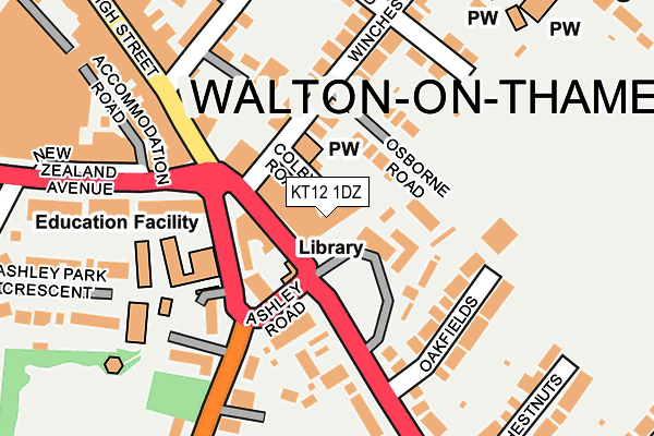
KT12 1DZ is located in the Walton Central electoral ward, within the local authority district of Elmbridge and the English Parliamentary constituency of Esher and Walton. The Sub Integrated Care Board (ICB) Location is NHS Surrey Heartlands ICB - 92A and the police force is Surrey. This postcode has been in use since June 2001.


GetTheData
Source: OS OpenMap – Local (Ordnance Survey)
Source: OS VectorMap District (Ordnance Survey)
Licence: Open Government Licence (requires attribution)
| Easting | 510306 |
| Northing | 166175 |
| Latitude | 51.383912 |
| Longitude | -0.416261 |
GetTheData
Source: Open Postcode Geo
Licence: Open Government Licence
| Country | England |
| Postcode District | KT12 |
➜ See where KT12 is on a map ➜ Where is Walton-on-Thames? | |
GetTheData
Source: Land Registry Price Paid Data
Licence: Open Government Licence
Elevation or altitude of KT12 1DZ as distance above sea level:
| Metres | Feet | |
|---|---|---|
| Elevation | 20m | 66ft |
Elevation is measured from the approximate centre of the postcode, to the nearest point on an OS contour line from OS Terrain 50, which has contour spacing of ten vertical metres.
➜ How high above sea level am I? Find the elevation of your current position using your device's GPS.
GetTheData
Source: Open Postcode Elevation
Licence: Open Government Licence
| Ward | Walton Central |
| Constituency | Esher And Walton |
GetTheData
Source: ONS Postcode Database
Licence: Open Government Licence
| Library (Hersham Road) | Walton-on-thames | 38m |
| Library (Ashley Road) | Walton-on-thames | 106m |
| High Street | Walton-on-thames | 174m |
| High Street | Walton-on-thames | 265m |
| Stompond Lane (Hersham Road) | Walton-on-thames | 334m |
| Walton-on-Thames Station | 1.2km |
| Hersham Station | 2km |
| Shepperton Station | 2.6km |
GetTheData
Source: NaPTAN
Licence: Open Government Licence
GetTheData
Source: ONS Postcode Database
Licence: Open Government Licence


➜ Get more ratings from the Food Standards Agency
GetTheData
Source: Food Standards Agency
Licence: FSA terms & conditions
| Last Collection | |||
|---|---|---|---|
| Location | Mon-Fri | Sat | Distance |
| High Street | 17:15 | 12:00 | 39m |
| High Street | 17:15 | 12:00 | 322m |
| Stompond Lane | 16:30 | 11:45 | 355m |
GetTheData
Source: Dracos
Licence: Creative Commons Attribution-ShareAlike
The below table lists the International Territorial Level (ITL) codes (formerly Nomenclature of Territorial Units for Statistics (NUTS) codes) and Local Administrative Units (LAU) codes for KT12 1DZ:
| ITL 1 Code | Name |
|---|---|
| TLJ | South East (England) |
| ITL 2 Code | Name |
| TLJ2 | Surrey, East and West Sussex |
| ITL 3 Code | Name |
| TLJ25 | West Surrey |
| LAU 1 Code | Name |
| E07000207 | Elmbridge |
GetTheData
Source: ONS Postcode Directory
Licence: Open Government Licence
The below table lists the Census Output Area (OA), Lower Layer Super Output Area (LSOA), and Middle Layer Super Output Area (MSOA) for KT12 1DZ:
| Code | Name | |
|---|---|---|
| OA | E00154855 | |
| LSOA | E01030359 | Elmbridge 007C |
| MSOA | E02006323 | Elmbridge 007 |
GetTheData
Source: ONS Postcode Directory
Licence: Open Government Licence
| KT12 1BU | High Street | 69m |
| KT12 2RL | Osborne Road | 71m |
| KT12 1HY | Ashley Road | 72m |
| KT12 1DJ | High Street | 106m |
| KT12 1LH | Hersham Road | 111m |
| KT12 1EG | Oakfields | 132m |
| KT12 1LA | Hersham Road | 137m |
| KT12 2RG | Winchester Road | 137m |
| KT12 1HU | Ashley Road | 142m |
| KT12 1PL | New Zealand Avenue | 146m |
GetTheData
Source: Open Postcode Geo; Land Registry Price Paid Data
Licence: Open Government Licence