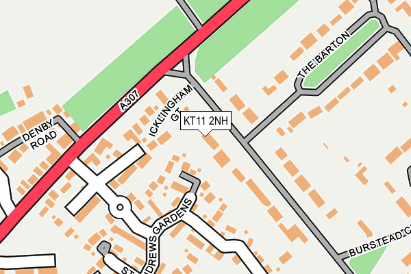
KT11 2NH lies on Icklingham Road in Cobham. KT11 2NH is located in the Oxshott and Stoke D'Abernon electoral ward, within the local authority district of Elmbridge and the English Parliamentary constituency of Esher and Walton. The Sub Integrated Care Board (ICB) Location is NHS Surrey Heartlands ICB - 92A and the police force is Surrey. This postcode has been in use since January 1980.


GetTheData
Source: OS OpenMap – Local (Ordnance Survey)
Source: OS VectorMap District (Ordnance Survey)
Licence: Open Government Licence (requires attribution)
| Easting | 511357 |
| Northing | 161041 |
| Latitude | 51.337562 |
| Longitude | -0.402768 |
GetTheData
Source: Open Postcode Geo
Licence: Open Government Licence
| Street | Icklingham Road |
| Town/City | Cobham |
| Country | England |
| Postcode District | KT11 |
➜ See where KT11 is on a map ➜ Where is Cobham? | |
GetTheData
Source: Land Registry Price Paid Data
Licence: Open Government Licence
Elevation or altitude of KT11 2NH as distance above sea level:
| Metres | Feet | |
|---|---|---|
| Elevation | 30m | 98ft |
Elevation is measured from the approximate centre of the postcode, to the nearest point on an OS contour line from OS Terrain 50, which has contour spacing of ten vertical metres.
➜ How high above sea level am I? Find the elevation of your current position using your device's GPS.
GetTheData
Source: Open Postcode Elevation
Licence: Open Government Licence
| Ward | Oxshott And Stoke D'abernon |
| Constituency | Esher And Walton |
GetTheData
Source: ONS Postcode Database
Licence: Open Government Licence
2021 12 NOV £4,215,000 |
2021 23 SEP £3,650,000 |
KINGSMERE HOUSE, 33, ICKLINGHAM ROAD, COBHAM, KT11 2NH 2021 25 MAR £4,150,000 |
ROSEWOOD, 39, ICKLINGHAM ROAD, COBHAM, KT11 2NH 2020 7 JUL £3,809,565 |
FAIRMONT, 37, ICKLINGHAM ROAD, COBHAM, KT11 2NH 2020 30 JAN £4,200,000 |
39, ICKLINGHAM ROAD, COBHAM, KT11 2NH 2010 22 JUL £1,885,000 |
KINGSMERE HOUSE, 33, ICKLINGHAM ROAD, COBHAM, KT11 2NH 2010 12 MAR £338,000 |
2007 27 JUL £1,575,000 |
2006 27 OCT £1,050,000 |
2002 23 AUG £1,070,500 |
GetTheData
Source: HM Land Registry Price Paid Data
Licence: Contains HM Land Registry data © Crown copyright and database right 2025. This data is licensed under the Open Government Licence v3.0.
| Icklingham Road (Portsmouth Road) | Cobham | 97m |
| Icklingham Road (Portsmouth Road) | Cobham | 106m |
| Lockhart Road | Cobham | 409m |
| Cottage Hospital (Portsmouth Road) | Cobham | 470m |
| Cottage Hospital (Portsmouth Road) | Cobham | 495m |
| Cobham & Stoke d'Abernon Station | 2.4km |
| Oxshott Station | 2.8km |
| Walton-on-Thames Station | 4km |
GetTheData
Source: NaPTAN
Licence: Open Government Licence
| Percentage of properties with Next Generation Access | 100.0% |
| Percentage of properties with Superfast Broadband | 100.0% |
| Percentage of properties with Ultrafast Broadband | 0.0% |
| Percentage of properties with Full Fibre Broadband | 0.0% |
Superfast Broadband is between 30Mbps and 300Mbps
Ultrafast Broadband is > 300Mbps
| Percentage of properties unable to receive 2Mbps | 0.0% |
| Percentage of properties unable to receive 5Mbps | 0.0% |
| Percentage of properties unable to receive 10Mbps | 0.0% |
| Percentage of properties unable to receive 30Mbps | 0.0% |
GetTheData
Source: Ofcom
Licence: Ofcom Terms of Use (requires attribution)
GetTheData
Source: ONS Postcode Database
Licence: Open Government Licence


➜ Get more ratings from the Food Standards Agency
GetTheData
Source: Food Standards Agency
Licence: FSA terms & conditions
| Last Collection | |||
|---|---|---|---|
| Location | Mon-Fri | Sat | Distance |
| St Andrews Gardens | 17:00 | 11:15 | 170m |
| Tartar Hill | 17:00 | 11:15 | 283m |
| Bursted Close | 17:00 | 11:45 | 302m |
GetTheData
Source: Dracos
Licence: Creative Commons Attribution-ShareAlike
The below table lists the International Territorial Level (ITL) codes (formerly Nomenclature of Territorial Units for Statistics (NUTS) codes) and Local Administrative Units (LAU) codes for KT11 2NH:
| ITL 1 Code | Name |
|---|---|
| TLJ | South East (England) |
| ITL 2 Code | Name |
| TLJ2 | Surrey, East and West Sussex |
| ITL 3 Code | Name |
| TLJ25 | West Surrey |
| LAU 1 Code | Name |
| E07000207 | Elmbridge |
GetTheData
Source: ONS Postcode Directory
Licence: Open Government Licence
The below table lists the Census Output Area (OA), Lower Layer Super Output Area (LSOA), and Middle Layer Super Output Area (MSOA) for KT11 2NH:
| Code | Name | |
|---|---|---|
| OA | E00154594 | |
| LSOA | E01030306 | Elmbridge 017F |
| MSOA | E02006333 | Elmbridge 017 |
GetTheData
Source: ONS Postcode Directory
Licence: Open Government Licence
| KT11 1AW | Icklingham Gate | 85m |
| KT11 1HP | Brunswick Grove | 148m |
| KT11 2NQ | Icklingham Road | 174m |
| KT11 1HG | St Andrews Gardens | 178m |
| KT11 1JU | Denby Road | 227m |
| KT11 2NJ | The Barton | 228m |
| KT11 1JR | Portsmouth Road | 240m |
| KT11 1JS | Daisy Cottages | 249m |
| KT11 1HU | Portsmouth Road | 249m |
| KT11 1FB | Denby Road | 254m |
GetTheData
Source: Open Postcode Geo; Land Registry Price Paid Data
Licence: Open Government Licence