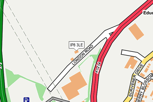
IP8 3LE lies on London Road in Washbrook, Ipswich. IP8 3LE is located in the Sproughton & Pinewood electoral ward, within the local authority district of Babergh and the English Parliamentary constituency of South Suffolk. The Sub Integrated Care Board (ICB) Location is NHS Suffolk and North East Essex ICB - 06L and the police force is Suffolk. This postcode has been in use since January 1980.


GetTheData
Source: OS OpenMap – Local (Ordnance Survey)
Source: OS VectorMap District (Ordnance Survey)
Licence: Open Government Licence (requires attribution)
| Easting | 612667 |
| Northing | 242821 |
| Latitude | 52.042987 |
| Longitude | 1.099684 |
GetTheData
Source: Open Postcode Geo
Licence: Open Government Licence
| Street | London Road |
| Locality | Washbrook |
| Town/City | Ipswich |
| Country | England |
| Postcode District | IP8 |
➜ See where IP8 is on a map ➜ Where is Ipswich? | |
GetTheData
Source: Land Registry Price Paid Data
Licence: Open Government Licence
Elevation or altitude of IP8 3LE as distance above sea level:
| Metres | Feet | |
|---|---|---|
| Elevation | 40m | 131ft |
Elevation is measured from the approximate centre of the postcode, to the nearest point on an OS contour line from OS Terrain 50, which has contour spacing of ten vertical metres.
➜ How high above sea level am I? Find the elevation of your current position using your device's GPS.
GetTheData
Source: Open Postcode Elevation
Licence: Open Government Licence
| Ward | Sproughton & Pinewood |
| Constituency | South Suffolk |
GetTheData
Source: ONS Postcode Database
Licence: Open Government Licence
2010 19 FEB £320,000 |
2007 9 FEB £345,000 |
GetTheData
Source: HM Land Registry Price Paid Data
Licence: Contains HM Land Registry data © Crown copyright and database right 2025. This data is licensed under the Open Government Licence v3.0.
| Broad Meadow (Scrivener Drive) | Pinebrook | 308m |
| Tesco (On Site) | Copdock | 317m |
| Greenspire Grove (Cottingham Road) | Pinebrook | 369m |
| Skylark Lane (Ward Road) | Pinebrook | 398m |
| Ward Road | Pinebrook | 398m |
| Ipswich Station | 3.2km |
| Westerfield Station | 6.2km |
GetTheData
Source: NaPTAN
Licence: Open Government Licence
| Percentage of properties with Next Generation Access | 100.0% |
| Percentage of properties with Superfast Broadband | 100.0% |
| Percentage of properties with Ultrafast Broadband | 0.0% |
| Percentage of properties with Full Fibre Broadband | 0.0% |
Superfast Broadband is between 30Mbps and 300Mbps
Ultrafast Broadband is > 300Mbps
| Percentage of properties unable to receive 2Mbps | 0.0% |
| Percentage of properties unable to receive 5Mbps | 0.0% |
| Percentage of properties unable to receive 10Mbps | 0.0% |
| Percentage of properties unable to receive 30Mbps | 0.0% |
GetTheData
Source: Ofcom
Licence: Ofcom Terms of Use (requires attribution)
GetTheData
Source: ONS Postcode Database
Licence: Open Government Licence


➜ Get more ratings from the Food Standards Agency
GetTheData
Source: Food Standards Agency
Licence: FSA terms & conditions
| Last Collection | |||
|---|---|---|---|
| Location | Mon-Fri | Sat | Distance |
| A12/A14 Copdock Interchange | 18:30 | 12:20 | 343m |
| 293 Belstead Road | 17:30 | 12:00 | 371m |
| 35 Wilmslow Drive (Flats) | 17:30 | 11:45 | 822m |
GetTheData
Source: Dracos
Licence: Creative Commons Attribution-ShareAlike
The below table lists the International Territorial Level (ITL) codes (formerly Nomenclature of Territorial Units for Statistics (NUTS) codes) and Local Administrative Units (LAU) codes for IP8 3LE:
| ITL 1 Code | Name |
|---|---|
| TLH | East |
| ITL 2 Code | Name |
| TLH1 | East Anglia |
| ITL 3 Code | Name |
| TLH14 | Suffolk CC |
| LAU 1 Code | Name |
| E07000200 | Babergh |
GetTheData
Source: ONS Postcode Directory
Licence: Open Government Licence
The below table lists the Census Output Area (OA), Lower Layer Super Output Area (LSOA), and Middle Layer Super Output Area (MSOA) for IP8 3LE:
| Code | Name | |
|---|---|---|
| OA | E00152249 | |
| LSOA | E01029879 | Babergh 005C |
| MSOA | E02006231 | Babergh 005 |
GetTheData
Source: ONS Postcode Directory
Licence: Open Government Licence
| IP8 3TT | Copdock Interchange | 218m |
| IP8 3ST | Cherry Blossom Close | 308m |
| IP8 3BU | Poplar Lane | 317m |
| IP8 3SA | Cottingham Road | 336m |
| IP8 3SY | Bishop Mews | 339m |
| IP8 3SZ | Greenspire Grove | 359m |
| IP8 3SP | Broad Meadow | 378m |
| IP8 3HL | Poplar Lane | 392m |
| IP8 3SQ | Oldfield Road | 423m |
| IP8 3SB | Ward Road | 432m |
GetTheData
Source: Open Postcode Geo; Land Registry Price Paid Data
Licence: Open Government Licence