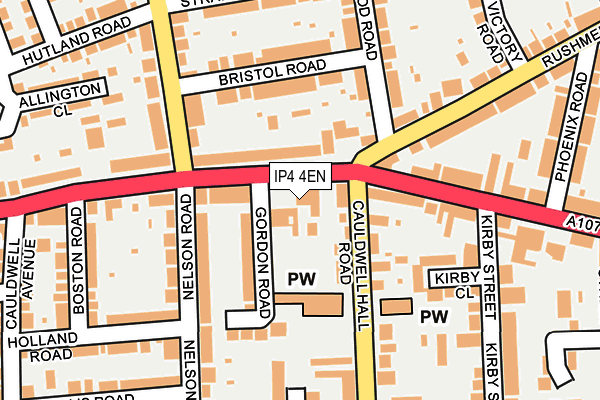
IP4 4EN lies on Woodbridge Road in Ipswich. IP4 4EN is located in the St John's electoral ward, within the local authority district of Ipswich and the English Parliamentary constituency of Ipswich. The Sub Integrated Care Board (ICB) Location is NHS Suffolk and North East Essex ICB - 06L and the police force is Suffolk. This postcode has been in use since January 1980.


GetTheData
Source: OS OpenMap – Local (Ordnance Survey)
Source: OS VectorMap District (Ordnance Survey)
Licence: Open Government Licence (requires attribution)
| Easting | 618191 |
| Northing | 245131 |
| Latitude | 52.061564 |
| Longitude | 1.181544 |
GetTheData
Source: Open Postcode Geo
Licence: Open Government Licence
| Street | Woodbridge Road |
| Town/City | Ipswich |
| Country | England |
| Postcode District | IP4 |
➜ See where IP4 is on a map ➜ Where is Ipswich? | |
GetTheData
Source: Land Registry Price Paid Data
Licence: Open Government Licence
Elevation or altitude of IP4 4EN as distance above sea level:
| Metres | Feet | |
|---|---|---|
| Elevation | 40m | 131ft |
Elevation is measured from the approximate centre of the postcode, to the nearest point on an OS contour line from OS Terrain 50, which has contour spacing of ten vertical metres.
➜ How high above sea level am I? Find the elevation of your current position using your device's GPS.
GetTheData
Source: Open Postcode Elevation
Licence: Open Government Licence
| Ward | St John's |
| Constituency | Ipswich |
GetTheData
Source: ONS Postcode Database
Licence: Open Government Licence
ROUNDWOOD SERVICE STATION, 436, WOODBRIDGE ROAD, IPSWICH, IP4 4EN 2006 30 JUN £400,000 |
GetTheData
Source: HM Land Registry Price Paid Data
Licence: Contains HM Land Registry data © Crown copyright and database right 2025. This data is licensed under the Open Government Licence v3.0.
| Gordon Road (Woodbridge Road) | Rushmere | 27m |
| Gordon Road (Woodbridge Road) | Rushmere | 38m |
| Nelson Road (Woodbridge Road) | Rushmere | 158m |
| Nelson Road (Woodbridge Road) | Rushmere | 160m |
| Fat Cat (Spring Road) | Ipswich | 265m |
| Derby Road (Ipswich) Station | 1.2km |
| Westerfield Station | 2.4km |
| Ipswich Station | 2.8km |
GetTheData
Source: NaPTAN
Licence: Open Government Licence
| Percentage of properties with Next Generation Access | 100.0% |
| Percentage of properties with Superfast Broadband | 100.0% |
| Percentage of properties with Ultrafast Broadband | 100.0% |
| Percentage of properties with Full Fibre Broadband | 0.0% |
Superfast Broadband is between 30Mbps and 300Mbps
Ultrafast Broadband is > 300Mbps
| Percentage of properties unable to receive 2Mbps | 0.0% |
| Percentage of properties unable to receive 5Mbps | 0.0% |
| Percentage of properties unable to receive 10Mbps | 0.0% |
| Percentage of properties unable to receive 30Mbps | 0.0% |
GetTheData
Source: Ofcom
Licence: Ofcom Terms of Use (requires attribution)
GetTheData
Source: ONS Postcode Database
Licence: Open Government Licence


➜ Get more ratings from the Food Standards Agency
GetTheData
Source: Food Standards Agency
Licence: FSA terms & conditions
| Last Collection | |||
|---|---|---|---|
| Location | Mon-Fri | Sat | Distance |
| 57 Milton Road | 17:30 | 12:05 | 313m |
| Spring Road | 17:30 | 12:00 | 473m |
| 201 Cauldwell Hall Road | 17:30 | 12:10 | 613m |
GetTheData
Source: Dracos
Licence: Creative Commons Attribution-ShareAlike
The below table lists the International Territorial Level (ITL) codes (formerly Nomenclature of Territorial Units for Statistics (NUTS) codes) and Local Administrative Units (LAU) codes for IP4 4EN:
| ITL 1 Code | Name |
|---|---|
| TLH | East |
| ITL 2 Code | Name |
| TLH1 | East Anglia |
| ITL 3 Code | Name |
| TLH14 | Suffolk CC |
| LAU 1 Code | Name |
| E07000202 | Ipswich |
GetTheData
Source: ONS Postcode Directory
Licence: Open Government Licence
The below table lists the Census Output Area (OA), Lower Layer Super Output Area (LSOA), and Middle Layer Super Output Area (MSOA) for IP4 4EN:
| Code | Name | |
|---|---|---|
| OA | E00152925 | |
| LSOA | E01030002 | Ipswich 008A |
| MSOA | E02006252 | Ipswich 008 |
GetTheData
Source: ONS Postcode Directory
Licence: Open Government Licence
| IP4 4EP | Woodbridge Road | 55m |
| IP4 4QB | Cauldwell Hall Road | 65m |
| IP4 4EL | Woodbridge Road | 75m |
| IP4 4QD | Cauldwell Hall Road | 88m |
| IP4 4LB | Rushmere Road | 89m |
| IP4 4HL | Gordon Road | 95m |
| IP4 4NA | Woodbridge Road | 98m |
| IP4 4QA | Woodbridge Road | 127m |
| IP4 4LX | Roundwood Road | 128m |
| IP4 4HT | Sidegate Lane | 138m |
GetTheData
Source: Open Postcode Geo; Land Registry Price Paid Data
Licence: Open Government Licence