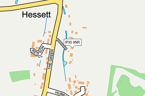
IP30 9NR lies on Beech Paddocks in Hessett, Bury St. Edmunds. IP30 9NR is located in the Rattlesden electoral ward, within the local authority district of Mid Suffolk and the English Parliamentary constituency of Bury St Edmunds. The Sub Integrated Care Board (ICB) Location is NHS Suffolk and North East Essex ICB - 07K and the police force is Suffolk. This postcode has been in use since September 1991.


GetTheData
Source: OS OpenMap – Local (Ordnance Survey)
Source: OS VectorMap District (Ordnance Survey)
Licence: Open Government Licence (requires attribution)
| Easting | 593641 |
| Northing | 261336 |
| Latitude | 52.216212 |
| Longitude | 0.833167 |
GetTheData
Source: Open Postcode Geo
Licence: Open Government Licence
| Street | Beech Paddocks |
| Locality | Hessett |
| Town/City | Bury St. Edmunds |
| Country | England |
| Postcode District | IP30 |
➜ See where IP30 is on a map ➜ Where is Hessett? | |
GetTheData
Source: Land Registry Price Paid Data
Licence: Open Government Licence
Elevation or altitude of IP30 9NR as distance above sea level:
| Metres | Feet | |
|---|---|---|
| Elevation | 70m | 230ft |
Elevation is measured from the approximate centre of the postcode, to the nearest point on an OS contour line from OS Terrain 50, which has contour spacing of ten vertical metres.
➜ How high above sea level am I? Find the elevation of your current position using your device's GPS.
GetTheData
Source: Open Postcode Elevation
Licence: Open Government Licence
| Ward | Rattlesden |
| Constituency | Bury St Edmunds |
GetTheData
Source: ONS Postcode Database
Licence: Open Government Licence
MAYFLOWERS, 4, BEECH PADDOCKS, HESSETT, BURY ST EDMUNDS, IP30 9NR 2018 27 NOV £500,000 |
MAYFLOWERS, 4, BEECH PADDOCKS, HESSETT, BURY ST EDMUNDS, IP30 9NR 2013 21 NOV £445,500 |
4, BEECH PADDOCKS, HESSETT, BURY ST. EDMUNDS, IP30 9NR 1999 23 FEB £172,500 |
2, BEECH PADDOCKS, HESSETT, BURY ST. EDMUNDS, IP30 9NR 1996 25 JUN £187,000 |
1, BEECH PADDOCKS, HESSETT, BURY ST. EDMUNDS, IP30 9NR 1996 29 MAR £195,000 |
GetTheData
Source: HM Land Registry Price Paid Data
Licence: Contains HM Land Registry data © Crown copyright and database right 2025. This data is licensed under the Open Government Licence v3.0.
| Hubbard's Lane (The Green) | Hessett | 183m |
| Five Bells (The Street) | Hessett | 412m |
| Five Bells (The Street) | Hessett | 436m |
| The Meade (Park Road) | Drinkstone | 1,623m |
| The Meade (Park Road) | Drinkstone | 1,626m |
| Thurston Station | 4.1km |
GetTheData
Source: NaPTAN
Licence: Open Government Licence
| Percentage of properties with Next Generation Access | 100.0% |
| Percentage of properties with Superfast Broadband | 100.0% |
| Percentage of properties with Ultrafast Broadband | 0.0% |
| Percentage of properties with Full Fibre Broadband | 0.0% |
Superfast Broadband is between 30Mbps and 300Mbps
Ultrafast Broadband is > 300Mbps
| Percentage of properties unable to receive 2Mbps | 0.0% |
| Percentage of properties unable to receive 5Mbps | 0.0% |
| Percentage of properties unable to receive 10Mbps | 0.0% |
| Percentage of properties unable to receive 30Mbps | 0.0% |
GetTheData
Source: Ofcom
Licence: Ofcom Terms of Use (requires attribution)
GetTheData
Source: ONS Postcode Database
Licence: Open Government Licence


➜ Get more ratings from the Food Standards Agency
GetTheData
Source: Food Standards Agency
Licence: FSA terms & conditions
| Last Collection | |||
|---|---|---|---|
| Location | Mon-Fri | Sat | Distance |
| Post Office, Kingshall Street | 16:30 | 11:15 | 2,056m |
| Old Post Office, Felsham Road | 15:45 | 11:30 | 3,086m |
| The Rectory | 16:45 | 10:45 | 3,423m |
GetTheData
Source: Dracos
Licence: Creative Commons Attribution-ShareAlike
The below table lists the International Territorial Level (ITL) codes (formerly Nomenclature of Territorial Units for Statistics (NUTS) codes) and Local Administrative Units (LAU) codes for IP30 9NR:
| ITL 1 Code | Name |
|---|---|
| TLH | East |
| ITL 2 Code | Name |
| TLH1 | East Anglia |
| ITL 3 Code | Name |
| TLH14 | Suffolk CC |
| LAU 1 Code | Name |
| E07000203 | Mid Suffolk |
GetTheData
Source: ONS Postcode Directory
Licence: Open Government Licence
The below table lists the Census Output Area (OA), Lower Layer Super Output Area (LSOA), and Middle Layer Super Output Area (MSOA) for IP30 9NR:
| Code | Name | |
|---|---|---|
| OA | E00153344 | |
| LSOA | E01030086 | Mid Suffolk 006D |
| MSOA | E02006266 | Mid Suffolk 006 |
GetTheData
Source: ONS Postcode Directory
Licence: Open Government Licence
| IP30 9BA | The Green | 128m |
| IP30 9BE | The Green | 161m |
| IP30 9GP | Shrubbery Close | 185m |
| IP30 9AZ | The Street | 283m |
| IP30 9BQ | The Green | 307m |
| IP30 9BG | Hubbards Lane | 317m |
| IP30 9AY | Lime Tree Close | 381m |
| IP30 9BP | Valentine Way | 436m |
| IP30 9AX | The Street | 510m |
| IP30 9AP | Muriel King Close | 542m |
GetTheData
Source: Open Postcode Geo; Land Registry Price Paid Data
Licence: Open Government Licence