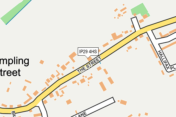
IP29 4HS lies on The Street in Shimpling, Bury St Edmunds. IP29 4HS is located in the Chadacre electoral ward, within the local authority district of Babergh and the English Parliamentary constituency of South Suffolk. The Sub Integrated Care Board (ICB) Location is NHS Suffolk and North East Essex ICB - 07K and the police force is Suffolk. This postcode has been in use since January 1980.


GetTheData
Source: OS OpenMap – Local (Ordnance Survey)
Source: OS VectorMap District (Ordnance Survey)
Licence: Open Government Licence (requires attribution)
| Easting | 587021 |
| Northing | 252834 |
| Latitude | 52.142131 |
| Longitude | 0.731668 |
GetTheData
Source: Open Postcode Geo
Licence: Open Government Licence
| Street | The Street |
| Locality | Shimpling |
| Town/City | Bury St Edmunds |
| Country | England |
| Postcode District | IP29 |
➜ See where IP29 is on a map ➜ Where is Shimpling Street? | |
GetTheData
Source: Land Registry Price Paid Data
Licence: Open Government Licence
Elevation or altitude of IP29 4HS as distance above sea level:
| Metres | Feet | |
|---|---|---|
| Elevation | 90m | 295ft |
Elevation is measured from the approximate centre of the postcode, to the nearest point on an OS contour line from OS Terrain 50, which has contour spacing of ten vertical metres.
➜ How high above sea level am I? Find the elevation of your current position using your device's GPS.
GetTheData
Source: Open Postcode Elevation
Licence: Open Government Licence
| Ward | Chadacre |
| Constituency | South Suffolk |
GetTheData
Source: ONS Postcode Database
Licence: Open Government Licence
| Hallifax Place (The Street) | Shimpling Street | 234m |
| Hallifax Place (The Street) | Shimpling Street | 235m |
| The Green (Unclassified) | Lawshall Green | 1,314m |
| The Green (Unclassified) | Lawshall Green | 1,324m |
| Free Church (The Street) | Hanningfields Green | 1,357m |
GetTheData
Source: NaPTAN
Licence: Open Government Licence
| Percentage of properties with Next Generation Access | 100.0% |
| Percentage of properties with Superfast Broadband | 100.0% |
| Percentage of properties with Ultrafast Broadband | 100.0% |
| Percentage of properties with Full Fibre Broadband | 100.0% |
Superfast Broadband is between 30Mbps and 300Mbps
Ultrafast Broadband is > 300Mbps
| Median download speed | 2.8Mbps |
| Average download speed | 2.8Mbps |
| Maximum download speed | 4.97Mbps |
| Median upload speed | 0.8Mbps |
| Average upload speed | 0.8Mbps |
| Maximum upload speed | 1.12Mbps |
| Percentage of properties unable to receive 2Mbps | 0.0% |
| Percentage of properties unable to receive 5Mbps | 0.0% |
| Percentage of properties unable to receive 10Mbps | 0.0% |
| Percentage of properties unable to receive 30Mbps | 0.0% |
GetTheData
Source: Ofcom
Licence: Ofcom Terms of Use (requires attribution)
Estimated total energy consumption in IP29 4HS by fuel type, 2015.
| Consumption (kWh) | 256,673 |
|---|---|
| Meter count | 38 |
| Mean (kWh/meter) | 6,755 |
| Median (kWh/meter) | 5,247 |
GetTheData
Source: Postcode level gas estimates: 2015 (experimental)
Source: Postcode level electricity estimates: 2015 (experimental)
Licence: Open Government Licence
GetTheData
Source: ONS Postcode Database
Licence: Open Government Licence

➜ Get more ratings from the Food Standards Agency
GetTheData
Source: Food Standards Agency
Licence: FSA terms & conditions
| Last Collection | |||
|---|---|---|---|
| Location | Mon-Fri | Sat | Distance |
| Cross Green | 17:00 | 08:30 | 3,690m |
| Bridge Street Long Melford | 16:00 | 10:30 | 3,808m |
| The Station | 09:00 | 07:30 | 3,808m |
GetTheData
Source: Dracos
Licence: Creative Commons Attribution-ShareAlike
The below table lists the International Territorial Level (ITL) codes (formerly Nomenclature of Territorial Units for Statistics (NUTS) codes) and Local Administrative Units (LAU) codes for IP29 4HS:
| ITL 1 Code | Name |
|---|---|
| TLH | East |
| ITL 2 Code | Name |
| TLH1 | East Anglia |
| ITL 3 Code | Name |
| TLH14 | Suffolk CC |
| LAU 1 Code | Name |
| E07000200 | Babergh |
GetTheData
Source: ONS Postcode Directory
Licence: Open Government Licence
The below table lists the Census Output Area (OA), Lower Layer Super Output Area (LSOA), and Middle Layer Super Output Area (MSOA) for IP29 4HS:
| Code | Name | |
|---|---|---|
| OA | E00152270 | |
| LSOA | E01029881 | Babergh 002A |
| MSOA | E02006228 | Babergh 002 |
GetTheData
Source: ONS Postcode Directory
Licence: Open Government Licence
| IP29 4HR | 193m | |
| IP29 4HT | Hallifax Place | 250m |
| IP29 4HP | Gents Lane | 255m |
| IP29 4HW | The Street | 261m |
| IP29 4HZ | Streetfield Close | 307m |
| IP29 4HE | Barn Meadow | 339m |
| IP29 4HJ | Barnfield | 355m |
| IP29 4HU | The Street | 420m |
| IP29 4HN | Slough Hill | 542m |
| IP29 4HL | Little Chadacre | 751m |
GetTheData
Source: Open Postcode Geo; Land Registry Price Paid Data
Licence: Open Government Licence