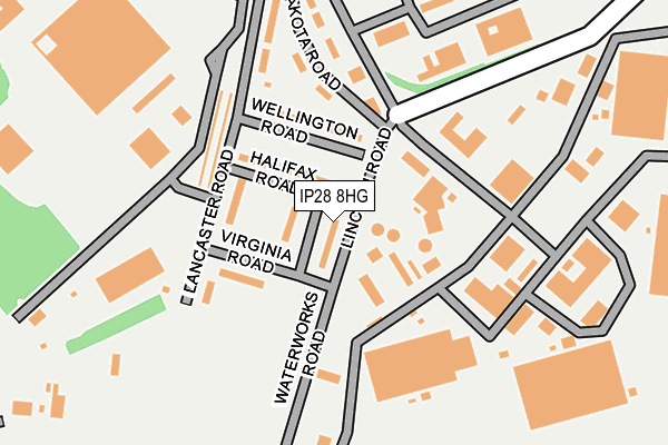
IP28 8HG is located in the The Rows electoral ward, within the local authority district of West Suffolk and the English Parliamentary constituency of West Suffolk. The Sub Integrated Care Board (ICB) Location is NHS Suffolk and North East Essex ICB - 07K and the police force is Suffolk. This postcode has been in use since January 1980.


GetTheData
Source: OS OpenMap – Local (Ordnance Survey)
Source: OS VectorMap District (Ordnance Survey)
Licence: Open Government Licence (requires attribution)
| Easting | 568193 |
| Northing | 277394 |
| Latitude | 52.368795 |
| Longitude | 0.469061 |
GetTheData
Source: Open Postcode Geo
Licence: Open Government Licence
| Country | England |
| Postcode District | IP28 |
➜ See where IP28 is on a map ➜ Where is Mildenhall? | |
GetTheData
Source: Land Registry Price Paid Data
Licence: Open Government Licence
Elevation or altitude of IP28 8HG as distance above sea level:
| Metres | Feet | |
|---|---|---|
| Elevation | 10m | 33ft |
Elevation is measured from the approximate centre of the postcode, to the nearest point on an OS contour line from OS Terrain 50, which has contour spacing of ten vertical metres.
➜ How high above sea level am I? Find the elevation of your current position using your device's GPS.
GetTheData
Source: Open Postcode Elevation
Licence: Open Government Licence
| Ward | The Rows |
| Constituency | West Suffolk |
GetTheData
Source: ONS Postcode Database
Licence: Open Government Licence
| Rookery Drove (Shippea Hill Road) | Beck Row | 636m |
| Rookery Drove (Shippea Hill Road) | Beck Row | 659m |
| Moss Edge Farm (Mildenhall Drove) | Beck Row | 797m |
| Moss Edge Farm (Mildenhall Drove) | Beck Row | 797m |
| Barleycorn Way (The Street) | Beck Row | 863m |
GetTheData
Source: NaPTAN
Licence: Open Government Licence
| Percentage of properties with Next Generation Access | 0.0% |
| Percentage of properties with Superfast Broadband | 0.0% |
| Percentage of properties with Ultrafast Broadband | 0.0% |
| Percentage of properties with Full Fibre Broadband | 0.0% |
Superfast Broadband is between 30Mbps and 300Mbps
Ultrafast Broadband is > 300Mbps
| Median download speed | 2.3Mbps |
| Average download speed | 2.2Mbps |
| Maximum download speed | 2.68Mbps |
| Median upload speed | 0.6Mbps |
| Average upload speed | 0.6Mbps |
| Maximum upload speed | 0.78Mbps |
| Percentage of properties unable to receive 2Mbps | 0.0% |
| Percentage of properties unable to receive 5Mbps | 100.0% |
| Percentage of properties unable to receive 10Mbps | 100.0% |
| Percentage of properties unable to receive 30Mbps | 100.0% |
GetTheData
Source: Ofcom
Licence: Ofcom Terms of Use (requires attribution)
GetTheData
Source: ONS Postcode Database
Licence: Open Government Licence


➜ Get more ratings from the Food Standards Agency
GetTheData
Source: Food Standards Agency
Licence: FSA terms & conditions
| Last Collection | |||
|---|---|---|---|
| Location | Mon-Fri | Sat | Distance |
| The Street | 11:00 | 11:15 | 711m |
| Holmsey Green | 15:30 | 09:15 | 1,305m |
| Comet Way | 11:30 | 11:30 | 3,114m |
GetTheData
Source: Dracos
Licence: Creative Commons Attribution-ShareAlike
The below table lists the International Territorial Level (ITL) codes (formerly Nomenclature of Territorial Units for Statistics (NUTS) codes) and Local Administrative Units (LAU) codes for IP28 8HG:
| ITL 1 Code | Name |
|---|---|
| TLH | East |
| ITL 2 Code | Name |
| TLH1 | East Anglia |
| ITL 3 Code | Name |
| TLH14 | Suffolk CC |
| LAU 1 Code | Name |
| E07000245 | West Suffolk |
GetTheData
Source: ONS Postcode Directory
Licence: Open Government Licence
The below table lists the Census Output Area (OA), Lower Layer Super Output Area (LSOA), and Middle Layer Super Output Area (MSOA) for IP28 8HG:
| Code | Name | |
|---|---|---|
| OA | E00173919 | |
| LSOA | E01032523 | Forest Heath 003F |
| MSOA | E02006240 | Forest Heath 003 |
GetTheData
Source: ONS Postcode Directory
Licence: Open Government Licence
| IP28 8DQ | York Close | 535m |
| IP28 8DP | The Grove | 576m |
| IP28 8DW | Stock Corner | 619m |
| IP28 8HW | Heron Close | 684m |
| IP28 8EE | Rookery Green | 684m |
| IP28 8HN | Plover Close | 691m |
| IP28 8ET | Blackthorn Close | 694m |
| IP28 8EL | Falcon Way | 725m |
| IP28 8HL | Blackbird Road | 743m |
| IP28 8RA | Pollards Lane | 752m |
GetTheData
Source: Open Postcode Geo; Land Registry Price Paid Data
Licence: Open Government Licence