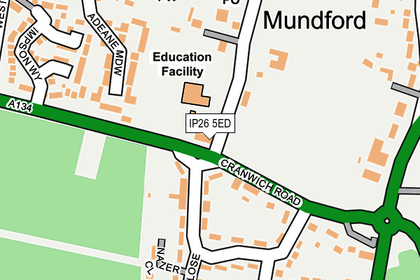
IP26 5ED is located in the Bedingfeld electoral ward, within the local authority district of Breckland and the English Parliamentary constituency of South West Norfolk. The Sub Integrated Care Board (ICB) Location is NHS Norfolk and Waveney ICB - 26A and the police force is Norfolk. This postcode has been in use since January 1980.


GetTheData
Source: OS OpenMap – Local (Ordnance Survey)
Source: OS VectorMap District (Ordnance Survey)
Licence: Open Government Licence (requires attribution)
| Easting | 580095 |
| Northing | 293578 |
| Latitude | 52.510338 |
| Longitude | 0.652377 |
GetTheData
Source: Open Postcode Geo
Licence: Open Government Licence
| Country | England |
| Postcode District | IP26 |
➜ See where IP26 is on a map ➜ Where is Mundford? | |
GetTheData
Source: Land Registry Price Paid Data
Licence: Open Government Licence
Elevation or altitude of IP26 5ED as distance above sea level:
| Metres | Feet | |
|---|---|---|
| Elevation | 20m | 66ft |
Elevation is measured from the approximate centre of the postcode, to the nearest point on an OS contour line from OS Terrain 50, which has contour spacing of ten vertical metres.
➜ How high above sea level am I? Find the elevation of your current position using your device's GPS.
GetTheData
Source: Open Postcode Elevation
Licence: Open Government Licence
| Ward | Bedingfeld |
| Constituency | South West Norfolk |
GetTheData
Source: ONS Postcode Database
Licence: Open Government Licence
| Old School (A134 Cranwich Road) | Mundford | 21m |
| Old School (A134 Cranwich Road) | Mundford | 28m |
| War Memorial (A1065 Swaffham Road) | Mundford | 287m |
| The Crown (Crown Road) | Mundford | 397m |
| The Crown (Crown Road) | Mundford | 408m |
GetTheData
Source: NaPTAN
Licence: Open Government Licence
| Percentage of properties with Next Generation Access | 100.0% |
| Percentage of properties with Superfast Broadband | 100.0% |
| Percentage of properties with Ultrafast Broadband | 0.0% |
| Percentage of properties with Full Fibre Broadband | 0.0% |
Superfast Broadband is between 30Mbps and 300Mbps
Ultrafast Broadband is > 300Mbps
| Percentage of properties unable to receive 2Mbps | 0.0% |
| Percentage of properties unable to receive 5Mbps | 0.0% |
| Percentage of properties unable to receive 10Mbps | 0.0% |
| Percentage of properties unable to receive 30Mbps | 0.0% |
GetTheData
Source: Ofcom
Licence: Ofcom Terms of Use (requires attribution)
GetTheData
Source: ONS Postcode Database
Licence: Open Government Licence


➜ Get more ratings from the Food Standards Agency
GetTheData
Source: Food Standards Agency
Licence: FSA terms & conditions
| Last Collection | |||
|---|---|---|---|
| Location | Mon-Fri | Sat | Distance |
| Fir Close | 17:15 | 10:00 | 185m |
| Post Office, St. Leonards St | 17:30 | 10:30 | 221m |
| Ickburgh Road | 16:00 | 11:30 | 1,014m |
GetTheData
Source: Dracos
Licence: Creative Commons Attribution-ShareAlike
The below table lists the International Territorial Level (ITL) codes (formerly Nomenclature of Territorial Units for Statistics (NUTS) codes) and Local Administrative Units (LAU) codes for IP26 5ED:
| ITL 1 Code | Name |
|---|---|
| TLH | East |
| ITL 2 Code | Name |
| TLH1 | East Anglia |
| ITL 3 Code | Name |
| TLH17 | Breckland and South Norfolk |
| LAU 1 Code | Name |
| E07000143 | Breckland |
GetTheData
Source: ONS Postcode Directory
Licence: Open Government Licence
The below table lists the Census Output Area (OA), Lower Layer Super Output Area (LSOA), and Middle Layer Super Output Area (MSOA) for IP26 5ED:
| Code | Name | |
|---|---|---|
| OA | E00134256 | |
| LSOA | E01026424 | Breckland 012A |
| MSOA | E02005514 | Breckland 012 |
GetTheData
Source: ONS Postcode Directory
Licence: Open Government Licence
| IP26 5EQ | Cranwich Road | 94m |
| IP26 5DU | Adeane Meadow | 155m |
| IP26 5EE | Fir Close | 182m |
| IP26 5DW | St Leonards Street | 244m |
| IP26 5EF | Brecklands | 251m |
| IP26 5JU | Impson Way | 256m |
| IP26 5DL | Billy Emms Court | 283m |
| IP26 5HF | The Grove | 302m |
| IP26 5DZ | Wissey View | 308m |
| IP26 5EG | Brecklands | 315m |
GetTheData
Source: Open Postcode Geo; Land Registry Price Paid Data
Licence: Open Government Licence