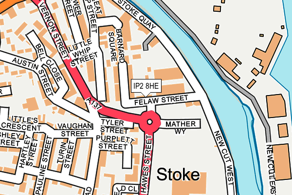
IP2 8HE is located in the Bridge electoral ward, within the local authority district of Ipswich and the English Parliamentary constituency of Ipswich. The Sub Integrated Care Board (ICB) Location is NHS Suffolk and North East Essex ICB - 06L and the police force is Suffolk. This postcode has been in use since January 1980.


GetTheData
Source: OS OpenMap – Local (Ordnance Survey)
Source: OS VectorMap District (Ordnance Survey)
Licence: Open Government Licence (requires attribution)
| Easting | 616597 |
| Northing | 243681 |
| Latitude | 52.049173 |
| Longitude | 1.157411 |
GetTheData
Source: Open Postcode Geo
Licence: Open Government Licence
| Country | England |
| Postcode District | IP2 |
➜ See where IP2 is on a map ➜ Where is Ipswich? | |
GetTheData
Source: Land Registry Price Paid Data
Licence: Open Government Licence
Elevation or altitude of IP2 8HE as distance above sea level:
| Metres | Feet | |
|---|---|---|
| Elevation | 10m | 33ft |
Elevation is measured from the approximate centre of the postcode, to the nearest point on an OS contour line from OS Terrain 50, which has contour spacing of ten vertical metres.
➜ How high above sea level am I? Find the elevation of your current position using your device's GPS.
GetTheData
Source: Open Postcode Elevation
Licence: Open Government Licence
| Ward | Bridge |
| Constituency | Ipswich |
GetTheData
Source: ONS Postcode Database
Licence: Open Government Licence
| Little Whip Street | Stoke | 119m |
| Riverside Way (Hawes Street) | Stoke | 125m |
| Co-op (Austin Street) | Stoke | 140m |
| Little Whip Street | Stoke | 147m |
| Kenyon Street (Wherstead Road) | Stoke | 239m |
| Ipswich Station | 0.9km |
| Derby Road (Ipswich) Station | 1.7km |
| Westerfield Station | 3.6km |
GetTheData
Source: NaPTAN
Licence: Open Government Licence
| Percentage of properties with Next Generation Access | 100.0% |
| Percentage of properties with Superfast Broadband | 100.0% |
| Percentage of properties with Ultrafast Broadband | 100.0% |
| Percentage of properties with Full Fibre Broadband | 0.0% |
Superfast Broadband is between 30Mbps and 300Mbps
Ultrafast Broadband is > 300Mbps
| Percentage of properties unable to receive 2Mbps | 0.0% |
| Percentage of properties unable to receive 5Mbps | 0.0% |
| Percentage of properties unable to receive 10Mbps | 0.0% |
| Percentage of properties unable to receive 30Mbps | 0.0% |
GetTheData
Source: Ofcom
Licence: Ofcom Terms of Use (requires attribution)
Estimated total energy consumption in IP2 8HE by fuel type, 2015.
| Consumption (kWh) | 379,248 |
|---|---|
| Meter count | 8 |
| Mean (kWh/meter) | 47,406 |
| Median (kWh/meter) | 47,406 |
GetTheData
Source: Postcode level gas estimates: 2015 (experimental)
Source: Postcode level electricity estimates: 2015 (experimental)
Licence: Open Government Licence
GetTheData
Source: ONS Postcode Database
Licence: Open Government Licence


➜ Get more ratings from the Food Standards Agency
GetTheData
Source: Food Standards Agency
Licence: FSA terms & conditions
| Last Collection | |||
|---|---|---|---|
| Location | Mon-Fri | Sat | Distance |
| Wherstead Road Post Office | 17:30 | 12:15 | 106m |
| Rapier Street | 17:30 | 11:45 | 486m |
| Bishops Hill | 17:30 | 12:25 | 502m |
GetTheData
Source: Dracos
Licence: Creative Commons Attribution-ShareAlike
The below table lists the International Territorial Level (ITL) codes (formerly Nomenclature of Territorial Units for Statistics (NUTS) codes) and Local Administrative Units (LAU) codes for IP2 8HE:
| ITL 1 Code | Name |
|---|---|
| TLH | East |
| ITL 2 Code | Name |
| TLH1 | East Anglia |
| ITL 3 Code | Name |
| TLH14 | Suffolk CC |
| LAU 1 Code | Name |
| E07000202 | Ipswich |
GetTheData
Source: ONS Postcode Directory
Licence: Open Government Licence
The below table lists the Census Output Area (OA), Lower Layer Super Output Area (LSOA), and Middle Layer Super Output Area (MSOA) for IP2 8HE:
| Code | Name | |
|---|---|---|
| OA | E00152743 | |
| LSOA | E01033122 | Ipswich 012F |
| MSOA | E02006256 | Ipswich 012 |
GetTheData
Source: ONS Postcode Directory
Licence: Open Government Licence
| IP2 8HD | Malting Terrace | 34m |
| IP2 8HA | Bulstrode Road | 49m |
| IP2 8HF | Tyler Street | 82m |
| IP2 8EZ | Great Whip Street | 86m |
| IP2 8HW | New Cut West | 103m |
| IP2 8HH | Purplett Street | 107m |
| IP2 8JQ | Wherstead Road | 112m |
| IP2 8SN | Stoke Quay | 120m |
| IP2 8JF | Vernon Street | 121m |
| IP2 8JG | Wherstead Road | 132m |
GetTheData
Source: Open Postcode Geo; Land Registry Price Paid Data
Licence: Open Government Licence