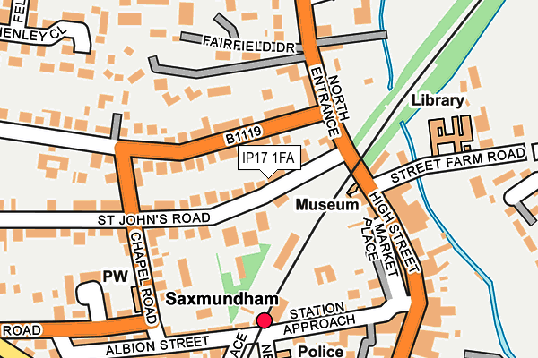
IP17 1FA lies on Howards Walk in Saxmundham. IP17 1FA is located in the Saxmundham electoral ward, within the local authority district of East Suffolk and the English Parliamentary constituency of Suffolk Coastal. The Sub Integrated Care Board (ICB) Location is NHS Suffolk and North East Essex ICB - 06L and the police force is Suffolk. This postcode has been in use since August 2006.


GetTheData
Source: OS OpenMap – Local (Ordnance Survey)
Source: OS VectorMap District (Ordnance Survey)
Licence: Open Government Licence (requires attribution)
| Easting | 638515 |
| Northing | 263305 |
| Latitude | 52.216306 |
| Longitude | 1.490233 |
GetTheData
Source: Open Postcode Geo
Licence: Open Government Licence
| Street | Howards Walk |
| Town/City | Saxmundham |
| Country | England |
| Postcode District | IP17 |
➜ See where IP17 is on a map ➜ Where is Saxmundham? | |
GetTheData
Source: Land Registry Price Paid Data
Licence: Open Government Licence
Elevation or altitude of IP17 1FA as distance above sea level:
| Metres | Feet | |
|---|---|---|
| Elevation | 20m | 66ft |
Elevation is measured from the approximate centre of the postcode, to the nearest point on an OS contour line from OS Terrain 50, which has contour spacing of ten vertical metres.
➜ How high above sea level am I? Find the elevation of your current position using your device's GPS.
GetTheData
Source: Open Postcode Elevation
Licence: Open Government Licence
| Ward | Saxmundham |
| Constituency | Suffolk Coastal |
GetTheData
Source: ONS Postcode Database
Licence: Open Government Licence
| Street Farm Road (High Street) | Saxmundham | 101m |
| Street Farm Road (High Street) | Saxmundham | 108m |
| Railway Station (Station Road) | Saxmundham | 165m |
| Railway Station | Saxmundham | 173m |
| Lambsale Meadow | Saxmundham | 183m |
| Saxmundham Station | 0.2km |
GetTheData
Source: NaPTAN
Licence: Open Government Licence
Estimated total energy consumption in IP17 1FA by fuel type, 2015.
| Consumption (kWh) | 7,600 |
|---|---|
| Meter count | 6 |
| Mean (kWh/meter) | 1,267 |
| Median (kWh/meter) | 1,502 |
GetTheData
Source: Postcode level gas estimates: 2015 (experimental)
Source: Postcode level electricity estimates: 2015 (experimental)
Licence: Open Government Licence
GetTheData
Source: ONS Postcode Database
Licence: Open Government Licence


➜ Get more ratings from the Food Standards Agency
GetTheData
Source: Food Standards Agency
Licence: FSA terms & conditions
| Last Collection | |||
|---|---|---|---|
| Location | Mon-Fri | Sat | Distance |
| St Johns Road | 17:00 | 11:30 | 157m |
| Railway Station | 17:00 | 11:30 | 165m |
| Co-op, 7 High Street | 17:30 | 12:15 | 284m |
GetTheData
Source: Dracos
Licence: Creative Commons Attribution-ShareAlike
The below table lists the International Territorial Level (ITL) codes (formerly Nomenclature of Territorial Units for Statistics (NUTS) codes) and Local Administrative Units (LAU) codes for IP17 1FA:
| ITL 1 Code | Name |
|---|---|
| TLH | East |
| ITL 2 Code | Name |
| TLH1 | East Anglia |
| ITL 3 Code | Name |
| TLH14 | Suffolk CC |
| LAU 1 Code | Name |
| E07000244 | East Suffolk |
GetTheData
Source: ONS Postcode Directory
Licence: Open Government Licence
The below table lists the Census Output Area (OA), Lower Layer Super Output Area (LSOA), and Middle Layer Super Output Area (MSOA) for IP17 1FA:
| Code | Name | |
|---|---|---|
| OA | E00154055 | |
| LSOA | E01030209 | Suffolk Coastal 003C |
| MSOA | E02006289 | Suffolk Coastal 003 |
GetTheData
Source: ONS Postcode Directory
Licence: Open Government Licence
| IP17 1BE | St Johns Road | 68m |
| IP17 1BA | Fairfield Road | 84m |
| IP17 1AY | North Entrance | 114m |
| IP17 1BP | Harpers Lane | 137m |
| IP17 1BG | Chapel Road | 149m |
| IP17 1AP | North Entrance | 150m |
| IP17 1AG | Angel Yard | 160m |
| IP17 1AH | Back Of Market Place | 162m |
| IP17 1BH | Chapel Road | 165m |
| IP17 1BW | Station Approach | 179m |
GetTheData
Source: Open Postcode Geo; Land Registry Price Paid Data
Licence: Open Government Licence