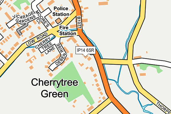
IP14 6SR lies on Cherry Tree Close in Debenham, Stowmarket. IP14 6SR is located in the Debenham electoral ward, within the local authority district of Mid Suffolk and the English Parliamentary constituency of Central Suffolk and North Ipswich. The Sub Integrated Care Board (ICB) Location is NHS Suffolk and North East Essex ICB - 06L and the police force is Suffolk. This postcode has been in use since January 2013.


GetTheData
Source: OS OpenMap – Local (Ordnance Survey)
Source: OS VectorMap District (Ordnance Survey)
Licence: Open Government Licence (requires attribution)
| Easting | 617532 |
| Northing | 262868 |
| Latitude | 52.221059 |
| Longitude | 1.183318 |
GetTheData
Source: Open Postcode Geo
Licence: Open Government Licence
| Street | Cherry Tree Close |
| Locality | Debenham |
| Town/City | Stowmarket |
| Country | England |
| Postcode District | IP14 |
➜ See where IP14 is on a map ➜ Where is Debenham? | |
GetTheData
Source: Land Registry Price Paid Data
Licence: Open Government Licence
Elevation or altitude of IP14 6SR as distance above sea level:
| Metres | Feet | |
|---|---|---|
| Elevation | 40m | 131ft |
Elevation is measured from the approximate centre of the postcode, to the nearest point on an OS contour line from OS Terrain 50, which has contour spacing of ten vertical metres.
➜ How high above sea level am I? Find the elevation of your current position using your device's GPS.
GetTheData
Source: Open Postcode Elevation
Licence: Open Government Licence
| Ward | Debenham |
| Constituency | Central Suffolk And North Ipswich |
GetTheData
Source: ONS Postcode Database
Licence: Open Government Licence
2020 27 MAR £480,000 |
2014 16 APR £421,000 |
3, CHERRY TREE CLOSE, DEBENHAM, STOWMARKET, IP14 6SR 2014 28 FEB £415,000 |
1, CHERRY TREE CLOSE, DEBENHAM, STOWMARKET, IP14 6SR 2013 20 MAY £437,500 |
4, CHERRY TREE CLOSE, DEBENHAM, STOWMARKET, IP14 6SR 2013 21 JAN £440,000 |
GetTheData
Source: HM Land Registry Price Paid Data
Licence: Contains HM Land Registry data © Crown copyright and database right 2025. This data is licensed under the Open Government Licence v3.0.
| Kenton Road | Debenham | 54m |
| Kenton Road | Debenham | 91m |
| Fire Station (Low Road) | Debenham | 125m |
| Fire Station (Low Road) | Debenham | 142m |
| Resource Centre (High Street) | Debenham | 216m |
GetTheData
Source: NaPTAN
Licence: Open Government Licence
| Percentage of properties with Next Generation Access | 100.0% |
| Percentage of properties with Superfast Broadband | 100.0% |
| Percentage of properties with Ultrafast Broadband | 0.0% |
| Percentage of properties with Full Fibre Broadband | 0.0% |
Superfast Broadband is between 30Mbps and 300Mbps
Ultrafast Broadband is > 300Mbps
| Percentage of properties unable to receive 2Mbps | 0.0% |
| Percentage of properties unable to receive 5Mbps | 0.0% |
| Percentage of properties unable to receive 10Mbps | 0.0% |
| Percentage of properties unable to receive 30Mbps | 0.0% |
GetTheData
Source: Ofcom
Licence: Ofcom Terms of Use (requires attribution)
GetTheData
Source: ONS Postcode Database
Licence: Open Government Licence

➜ Get more ratings from the Food Standards Agency
GetTheData
Source: Food Standards Agency
Licence: FSA terms & conditions
| Last Collection | |||
|---|---|---|---|
| Location | Mon-Fri | Sat | Distance |
| Low Road | 12:00 | 11:30 | 148m |
| Lock Close | 11:00 | 11:00 | 415m |
| Post Office, High Street | 16:10 | 11:30 | 491m |
GetTheData
Source: Dracos
Licence: Creative Commons Attribution-ShareAlike
The below table lists the International Territorial Level (ITL) codes (formerly Nomenclature of Territorial Units for Statistics (NUTS) codes) and Local Administrative Units (LAU) codes for IP14 6SR:
| ITL 1 Code | Name |
|---|---|
| TLH | East |
| ITL 2 Code | Name |
| TLH1 | East Anglia |
| ITL 3 Code | Name |
| TLH14 | Suffolk CC |
| LAU 1 Code | Name |
| E07000203 | Mid Suffolk |
GetTheData
Source: ONS Postcode Directory
Licence: Open Government Licence
The below table lists the Census Output Area (OA), Lower Layer Super Output Area (LSOA), and Middle Layer Super Output Area (MSOA) for IP14 6SR:
| Code | Name | |
|---|---|---|
| OA | E00153140 | |
| LSOA | E01030048 | Mid Suffolk 007A |
| MSOA | E02006267 | Mid Suffolk 007 |
GetTheData
Source: ONS Postcode Directory
Licence: Open Government Licence
| IP14 6LB | Ipswich Road | 71m |
| IP14 6QQ | Deben Rise | 91m |
| IP14 6ST | River Close | 120m |
| IP14 6QT | Cherry Tree Lane | 122m |
| IP14 6QR | High Street | 136m |
| IP14 6QS | High Street | 160m |
| IP14 6NF | 176m | |
| IP14 6BH | Ipswich Road | 183m |
| IP14 6QU | Low Road | 186m |
| IP14 6RU | Moores Close | 224m |
GetTheData
Source: Open Postcode Geo; Land Registry Price Paid Data
Licence: Open Government Licence