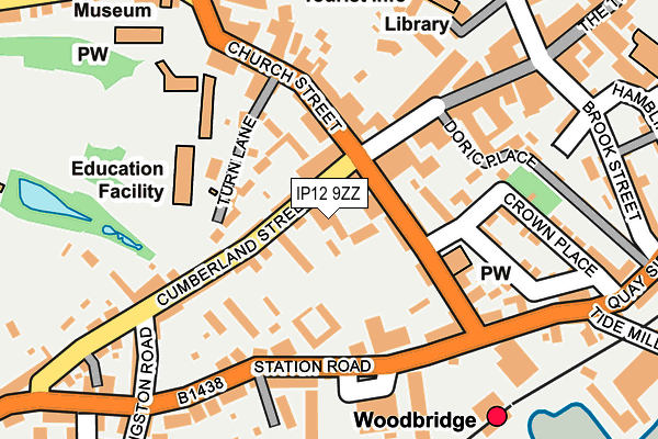
IP12 9ZZ is located in the Woodbridge electoral ward, within the local authority district of East Suffolk and the English Parliamentary constituency of Suffolk Coastal. The Sub Integrated Care Board (ICB) Location is NHS Suffolk and North East Essex ICB - 06L and the police force is Suffolk. This postcode has been in use since March 2016.


GetTheData
Source: OS OpenMap – Local (Ordnance Survey)
Source: OS VectorMap District (Ordnance Survey)
Licence: Open Government Licence (requires attribution)
| Easting | 627239 |
| Northing | 248921 |
| Latitude | 52.091948 |
| Longitude | 1.315824 |
GetTheData
Source: Open Postcode Geo
Licence: Open Government Licence
| Country | England |
| Postcode District | IP12 |
➜ See where IP12 is on a map | |
GetTheData
Source: Land Registry Price Paid Data
Licence: Open Government Licence
Elevation or altitude of IP12 9ZZ as distance above sea level:
| Metres | Feet | |
|---|---|---|
| Elevation | 10m | 33ft |
Elevation is measured from the approximate centre of the postcode, to the nearest point on an OS contour line from OS Terrain 50, which has contour spacing of ten vertical metres.
➜ How high above sea level am I? Find the elevation of your current position using your device's GPS.
GetTheData
Source: Open Postcode Elevation
Licence: Open Government Licence
| Ward | Woodbridge |
| Constituency | Suffolk Coastal |
GetTheData
Source: ONS Postcode Database
Licence: Open Government Licence
| The Crown (Quay Street) | Woodbridge | 46m |
| Deben Pool (Station Road) | Woodbridge | 140m |
| Deben Pool (Station Road) | Woodbridge | 143m |
| Railway Station (Forecourt) | Woodbridge | 211m |
| Museum (Market Hill) | Woodbridge | 281m |
| Woodbridge Station | 0.2km |
| Melton (Suffolk) Station | 2.1km |
GetTheData
Source: NaPTAN
Licence: Open Government Licence
GetTheData
Source: ONS Postcode Database
Licence: Open Government Licence


➜ Get more ratings from the Food Standards Agency
GetTheData
Source: Food Standards Agency
Licence: FSA terms & conditions
| Last Collection | |||
|---|---|---|---|
| Location | Mon-Fri | Sat | Distance |
| Royal Mail Cumberland Street | 17:30 | 13:30 | 26m |
| Woodbridge Delivery Office | 17:30 | 13:00 | 28m |
| Railway Station | 17:15 | 12:00 | 218m |
GetTheData
Source: Dracos
Licence: Creative Commons Attribution-ShareAlike
The below table lists the International Territorial Level (ITL) codes (formerly Nomenclature of Territorial Units for Statistics (NUTS) codes) and Local Administrative Units (LAU) codes for IP12 9ZZ:
| ITL 1 Code | Name |
|---|---|
| TLH | East |
| ITL 2 Code | Name |
| TLH1 | East Anglia |
| ITL 3 Code | Name |
| TLH14 | Suffolk CC |
| LAU 1 Code | Name |
| E07000244 | East Suffolk |
GetTheData
Source: ONS Postcode Directory
Licence: Open Government Licence
The below table lists the Census Output Area (OA), Lower Layer Super Output Area (LSOA), and Middle Layer Super Output Area (MSOA) for IP12 9ZZ:
| Code | Name | |
|---|---|---|
| OA | E00154021 | |
| LSOA | E01030203 | Suffolk Coastal 008C |
| MSOA | E02006294 | Suffolk Coastal 008 |
GetTheData
Source: ONS Postcode Directory
Licence: Open Government Licence
| IP12 4AP | Athenrye Court | 46m |
| IP12 4AB | Cumberland Street | 51m |
| IP12 4AH | Cumberland Street | 78m |
| IP12 4AR | Turn Lane | 83m |
| IP12 1BX | Quay Street | 94m |
| IP12 1AG | Thoroughfare | 100m |
| IP12 1DW | Stone Place | 110m |
| IP12 1AF | Thoroughfare | 110m |
| IP12 4AU | Station Road | 112m |
| IP12 1DR | Carmelite Place | 115m |
GetTheData
Source: Open Postcode Geo; Land Registry Price Paid Data
Licence: Open Government Licence