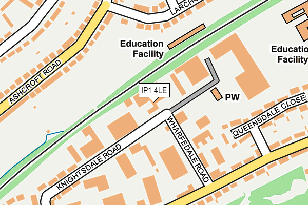
IP1 4LE is located in the Castle Hill electoral ward, within the local authority district of Ipswich and the English Parliamentary constituency of Central Suffolk and North Ipswich. The Sub Integrated Care Board (ICB) Location is NHS Suffolk and North East Essex ICB - 06L and the police force is Suffolk. This postcode has been in use since January 1980.


GetTheData
Source: OS OpenMap – Local (Ordnance Survey)
Source: OS VectorMap District (Ordnance Survey)
Licence: Open Government Licence (requires attribution)
| Easting | 615386 |
| Northing | 246496 |
| Latitude | 52.074915 |
| Longitude | 1.141553 |
GetTheData
Source: Open Postcode Geo
Licence: Open Government Licence
| Country | England |
| Postcode District | IP1 |
➜ See where IP1 is on a map ➜ Where is Ipswich? | |
GetTheData
Source: Land Registry Price Paid Data
Licence: Open Government Licence
Elevation or altitude of IP1 4LE as distance above sea level:
| Metres | Feet | |
|---|---|---|
| Elevation | 30m | 98ft |
Elevation is measured from the approximate centre of the postcode, to the nearest point on an OS contour line from OS Terrain 50, which has contour spacing of ten vertical metres.
➜ How high above sea level am I? Find the elevation of your current position using your device's GPS.
GetTheData
Source: Open Postcode Elevation
Licence: Open Government Licence
| Ward | Castle Hill |
| Constituency | Central Suffolk And North Ipswich |
GetTheData
Source: ONS Postcode Database
Licence: Open Government Licence
| Wharfdale Road (Dales Road) | Broom Hill | 197m |
| Wharfdale Road (Dales Road) | Broom Hill | 212m |
| Knightsdale Road (Dales Road) | Broom Hill | 240m |
| Knightsdale Road (Dales Road) | Broom Hill | 274m |
| Pinecroft Road (Elmcroft Road) | Castle Hill | 309m |
| Westerfield Station | 1.8km |
| Ipswich Station | 2.7km |
| Derby Road (Ipswich) Station | 3.9km |
GetTheData
Source: NaPTAN
Licence: Open Government Licence
GetTheData
Source: ONS Postcode Database
Licence: Open Government Licence


➜ Get more ratings from the Food Standards Agency
GetTheData
Source: Food Standards Agency
Licence: FSA terms & conditions
| Last Collection | |||
|---|---|---|---|
| Location | Mon-Fri | Sat | Distance |
| 61 Dale Hall Lane | 17:30 | 12:05 | 669m |
| Fircroft Road Post Office | 17:30 | 12:15 | 928m |
| 6 Warrington Road | 18:30 | 13:00 | 970m |
GetTheData
Source: Dracos
Licence: Creative Commons Attribution-ShareAlike
The below table lists the International Territorial Level (ITL) codes (formerly Nomenclature of Territorial Units for Statistics (NUTS) codes) and Local Administrative Units (LAU) codes for IP1 4LE:
| ITL 1 Code | Name |
|---|---|
| TLH | East |
| ITL 2 Code | Name |
| TLH1 | East Anglia |
| ITL 3 Code | Name |
| TLH14 | Suffolk CC |
| LAU 1 Code | Name |
| E07000202 | Ipswich |
GetTheData
Source: ONS Postcode Directory
Licence: Open Government Licence
The below table lists the Census Output Area (OA), Lower Layer Super Output Area (LSOA), and Middle Layer Super Output Area (MSOA) for IP1 4LE:
| Code | Name | |
|---|---|---|
| OA | E00152768 | |
| LSOA | E01029977 | Ipswich 002E |
| MSOA | E02006246 | Ipswich 002 |
GetTheData
Source: ONS Postcode Directory
Licence: Open Government Licence
| IP1 4JJ | Knightsdale Road | 75m |
| IP1 4JP | Wharfedale Road | 135m |
| IP1 4JR | Dales Road | 188m |
| IP1 6AR | Larchcroft Road | 195m |
| IP1 6AE | Ashcroft Road | 214m |
| IP1 4JQ | Knightsdale Road | 215m |
| IP1 4JZ | Queensdale Close | 241m |
| IP1 6AF | Ashcroft Road | 311m |
| IP1 4JY | Dales Road | 315m |
| IP1 6NB | Elmcroft Road | 318m |
GetTheData
Source: Open Postcode Geo; Land Registry Price Paid Data
Licence: Open Government Licence