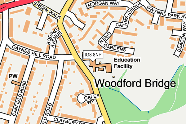
IG8 8NP is located in the Bridge electoral ward, within the London borough of Redbridge and the English Parliamentary constituency of Ilford North. The Sub Integrated Care Board (ICB) Location is NHS North East London ICB - A3A8R and the police force is Metropolitan Police. This postcode has been in use since January 1980.


GetTheData
Source: OS OpenMap – Local (Ordnance Survey)
Source: OS VectorMap District (Ordnance Survey)
Licence: Open Government Licence (requires attribution)
| Easting | 542424 |
| Northing | 191453 |
| Latitude | 51.603912 |
| Longitude | 0.055166 |
GetTheData
Source: Open Postcode Geo
Licence: Open Government Licence
| Country | England |
| Postcode District | IG8 |
➜ See where IG8 is on a map ➜ Where is Woodford? | |
GetTheData
Source: Land Registry Price Paid Data
Licence: Open Government Licence
Elevation or altitude of IG8 8NP as distance above sea level:
| Metres | Feet | |
|---|---|---|
| Elevation | 30m | 98ft |
Elevation is measured from the approximate centre of the postcode, to the nearest point on an OS contour line from OS Terrain 50, which has contour spacing of ten vertical metres.
➜ How high above sea level am I? Find the elevation of your current position using your device's GPS.
GetTheData
Source: Open Postcode Elevation
Licence: Open Government Licence
| Ward | Bridge |
| Constituency | Ilford North |
GetTheData
Source: ONS Postcode Database
Licence: Open Government Licence
| Roding Lane North | Woodford Bridge | 207m |
| Manor Road (Ig8) | Woodford Bridge | 253m |
| Ashton Playing Fields | Woodford Bridge | 358m |
| Ashton Playing Fields (Chigwell Road) | Woodford Bridge | 411m |
| Cross Road (Ig8) | Woodford Bridge | 475m |
| Woodford Underground Station | Woodford | 1,505m |
| Roding Valley Underground Station | Woodford | 1,680m |
| Highams Park Station | 3.9km |
| Wood Street Station | 4.4km |
| Chingford Station | 4.5km |
GetTheData
Source: NaPTAN
Licence: Open Government Licence
GetTheData
Source: ONS Postcode Database
Licence: Open Government Licence


➜ Get more ratings from the Food Standards Agency
GetTheData
Source: Food Standards Agency
Licence: FSA terms & conditions
| Last Collection | |||
|---|---|---|---|
| Location | Mon-Fri | Sat | Distance |
| Highfield Road | 17:30 | 12:00 | 223m |
| Woodford Bridge Post Office | 17:30 | 12:00 | 284m |
| Nora House 87 Forest Road | 16:45 | 348m | |
GetTheData
Source: Dracos
Licence: Creative Commons Attribution-ShareAlike
The below table lists the International Territorial Level (ITL) codes (formerly Nomenclature of Territorial Units for Statistics (NUTS) codes) and Local Administrative Units (LAU) codes for IG8 8NP:
| ITL 1 Code | Name |
|---|---|
| TLI | London |
| ITL 2 Code | Name |
| TLI5 | Outer London - East and North East |
| ITL 3 Code | Name |
| TLI53 | Redbridge and Waltham Forest |
| LAU 1 Code | Name |
| E09000026 | Redbridge |
GetTheData
Source: ONS Postcode Directory
Licence: Open Government Licence
The below table lists the Census Output Area (OA), Lower Layer Super Output Area (LSOA), and Middle Layer Super Output Area (MSOA) for IG8 8NP:
| Code | Name | |
|---|---|---|
| OA | E00018436 | |
| LSOA | E01003657 | Redbridge 005B |
| MSOA | E02000755 | Redbridge 005 |
GetTheData
Source: ONS Postcode Directory
Licence: Open Government Licence
| IG8 8DJ | Owen Gardens | 80m |
| IG8 8NN | Roding Lane North | 93m |
| IG8 8NR | Roding Lane North | 117m |
| IG8 8FD | Westfield Park Drive | 118m |
| IG8 8HY | Gaynes Hill Road | 125m |
| IG8 8NW | Gales Way | 132m |
| IG8 8HZ | Roding Avenue | 154m |
| IG8 8JA | Highfield Road | 160m |
| IG8 8FF | Roding Avenue | 162m |
| IG8 8DH | Cairns Avenue | 163m |
GetTheData
Source: Open Postcode Geo; Land Registry Price Paid Data
Licence: Open Government Licence