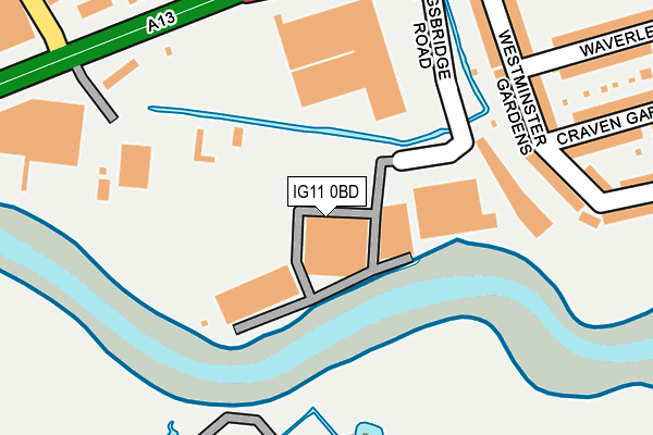
IG11 0BD is located in the Thames View electoral ward, within the London borough of Barking and Dagenham and the English Parliamentary constituency of Barking. The Sub Integrated Care Board (ICB) Location is NHS North East London ICB - A3A8R and the police force is Metropolitan Police. This postcode has been in use since January 1980.


GetTheData
Source: OS OpenMap – Local (Ordnance Survey)
Source: OS VectorMap District (Ordnance Survey)
Licence: Open Government Licence (requires attribution)
| Easting | 544881 |
| Northing | 182970 |
| Latitude | 51.527063 |
| Longitude | 0.087153 |
GetTheData
Source: Open Postcode Geo
Licence: Open Government Licence
| Country | England |
| Postcode District | IG11 |
➜ See where IG11 is on a map ➜ Where is Barking? | |
GetTheData
Source: Land Registry Price Paid Data
Licence: Open Government Licence
Elevation or altitude of IG11 0BD as distance above sea level:
| Metres | Feet | |
|---|---|---|
| Elevation | 0m | 0ft |
Elevation is measured from the approximate centre of the postcode, to the nearest point on an OS contour line from OS Terrain 50, which has contour spacing of ten vertical metres.
➜ How high above sea level am I? Find the elevation of your current position using your device's GPS.
GetTheData
Source: Open Postcode Elevation
Licence: Open Government Licence
| Ward | Thames View |
| Constituency | Barking |
GetTheData
Source: ONS Postcode Database
Licence: Open Government Licence
| King Edwards Road Alfreds Way (Alfreds Way (A13)) | Barking | 228m |
| King Edwards Road Alfreds Way (Alfreds Way (A13)) | Barking | 243m |
| Greatfields Road (King Edwards Road) | Barking | 321m |
| River Road Movers Lane (Alfreds Way) | Creekmouth | 383m |
| Gascoigne Estate (Gascoigne Road) | Barking | 421m |
| Barking Underground Station | Barking | 1,427m |
| Upney Underground Station | Upney | 1,607m |
| Barking Station | 1.4km |
| Ilford Station | 3.8km |
| Woodgrange Park Station | 3.9km |
GetTheData
Source: NaPTAN
Licence: Open Government Licence
GetTheData
Source: ONS Postcode Database
Licence: Open Government Licence


➜ Get more ratings from the Food Standards Agency
GetTheData
Source: Food Standards Agency
Licence: FSA terms & conditions
| Last Collection | |||
|---|---|---|---|
| Location | Mon-Fri | Sat | Distance |
| Bedford Road | 17:30 | 11:30 | 327m |
| St. Johns Road | 17:00 | 12:30 | 600m |
| Movers Lane | 17:30 | 12:45 | 821m |
GetTheData
Source: Dracos
Licence: Creative Commons Attribution-ShareAlike
The below table lists the International Territorial Level (ITL) codes (formerly Nomenclature of Territorial Units for Statistics (NUTS) codes) and Local Administrative Units (LAU) codes for IG11 0BD:
| ITL 1 Code | Name |
|---|---|
| TLI | London |
| ITL 2 Code | Name |
| TLI5 | Outer London - East and North East |
| ITL 3 Code | Name |
| TLI52 | Barking & Dagenham and Havering |
| LAU 1 Code | Name |
| E09000002 | Barking and Dagenham |
GetTheData
Source: ONS Postcode Directory
Licence: Open Government Licence
The below table lists the Census Output Area (OA), Lower Layer Super Output Area (LSOA), and Middle Layer Super Output Area (MSOA) for IG11 0BD:
| Code | Name | |
|---|---|---|
| OA | E00000470 | |
| LSOA | E01000092 | Barking and Dagenham 019E |
| MSOA | E02000020 | Barking and Dagenham 019 |
GetTheData
Source: ONS Postcode Directory
Licence: Open Government Licence
| IG11 0BJ | Westminster Gardens | 209m |
| IG11 7TT | King Edwards Road | 266m |
| IG11 0BN | Craven Gardens | 279m |
| IG11 0BL | Westminster Gardens | 279m |
| IG11 0AX | Alfreds Way | 299m |
| IG11 7TU | King Edwards Road | 300m |
| IG11 0BH | Waverley Gardens | 320m |
| IG11 7ED | Dovehouse Mead | 344m |
| IG11 7EE | Wheelers Cross | 350m |
| IG11 0BW | Craven Gardens | 361m |
GetTheData
Source: Open Postcode Geo; Land Registry Price Paid Data
Licence: Open Government Licence