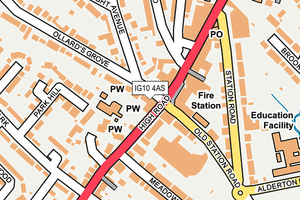
IG10 4AS is located in the Loughton Forest electoral ward, within the local authority district of Epping Forest and the English Parliamentary constituency of Epping Forest. The Sub Integrated Care Board (ICB) Location is NHS Hertfordshire and West Essex ICB - 07H and the police force is Essex. This postcode has been in use since June 1999.


GetTheData
Source: OS OpenMap – Local (Ordnance Survey)
Source: OS VectorMap District (Ordnance Survey)
Licence: Open Government Licence (requires attribution)
| Easting | 542055 |
| Northing | 195948 |
| Latitude | 51.644395 |
| Longitude | 0.051663 |
GetTheData
Source: Open Postcode Geo
Licence: Open Government Licence
| Country | England |
| Postcode District | IG10 |
➜ See where IG10 is on a map ➜ Where is Loughton? | |
GetTheData
Source: Land Registry Price Paid Data
Licence: Open Government Licence
Elevation or altitude of IG10 4AS as distance above sea level:
| Metres | Feet | |
|---|---|---|
| Elevation | 40m | 131ft |
Elevation is measured from the approximate centre of the postcode, to the nearest point on an OS contour line from OS Terrain 50, which has contour spacing of ten vertical metres.
➜ How high above sea level am I? Find the elevation of your current position using your device's GPS.
GetTheData
Source: Open Postcode Elevation
Licence: Open Government Licence
| Ward | Loughton Forest |
| Constituency | Epping Forest |
GetTheData
Source: ONS Postcode Database
Licence: Open Government Licence
| The Crown (High Road) | Loughton | 48m |
| The Crown (High Road) | Loughton | 48m |
| The Crown (Old Station Road) | Loughton | 59m |
| Sainsburys Store (Old Station Road) | Loughton | 176m |
| Upper Park (High Road) | Loughton | 258m |
| Loughton Underground Station | Loughton | 421m |
| Chingford Station | 3.2km |
| Highams Park Station | 5.4km |
GetTheData
Source: NaPTAN
Licence: Open Government Licence
GetTheData
Source: ONS Postcode Database
Licence: Open Government Licence


➜ Get more ratings from the Food Standards Agency
GetTheData
Source: Food Standards Agency
Licence: FSA terms & conditions
| Last Collection | |||
|---|---|---|---|
| Location | Mon-Fri | Sat | Distance |
| Brook Road | 17:15 | 12:00 | 333m |
| Upper Park Road | 17:00 | 12:00 | 342m |
| Loughton Station | 18:30 | 12:00 | 412m |
GetTheData
Source: Dracos
Licence: Creative Commons Attribution-ShareAlike
The below table lists the International Territorial Level (ITL) codes (formerly Nomenclature of Territorial Units for Statistics (NUTS) codes) and Local Administrative Units (LAU) codes for IG10 4AS:
| ITL 1 Code | Name |
|---|---|
| TLH | East |
| ITL 2 Code | Name |
| TLH3 | Essex |
| ITL 3 Code | Name |
| TLH35 | West Essex |
| LAU 1 Code | Name |
| E07000072 | Epping Forest |
GetTheData
Source: ONS Postcode Directory
Licence: Open Government Licence
The below table lists the Census Output Area (OA), Lower Layer Super Output Area (LSOA), and Middle Layer Super Output Area (MSOA) for IG10 4AS:
| Code | Name | |
|---|---|---|
| OA | E00110650 | |
| LSOA | E01021782 | Epping Forest 014C |
| MSOA | E02004540 | Epping Forest 014 |
GetTheData
Source: ONS Postcode Directory
Licence: Open Government Licence
| IG10 4DL | The Chestnuts | 10m |
| IG10 4HT | High Road | 17m |
| IG10 4DN | Ollards Grove | 33m |
| IG10 4HJ | High Road | 43m |
| IG10 4LT | High Road | 70m |
| IG10 4HH | High Road | 70m |
| IG10 4QU | High Road | 121m |
| IG10 4DP | Connaught Avenue | 127m |
| IG10 4LF | High Road | 127m |
| IG10 4NZ | Station Road | 147m |
GetTheData
Source: Open Postcode Geo; Land Registry Price Paid Data
Licence: Open Government Licence