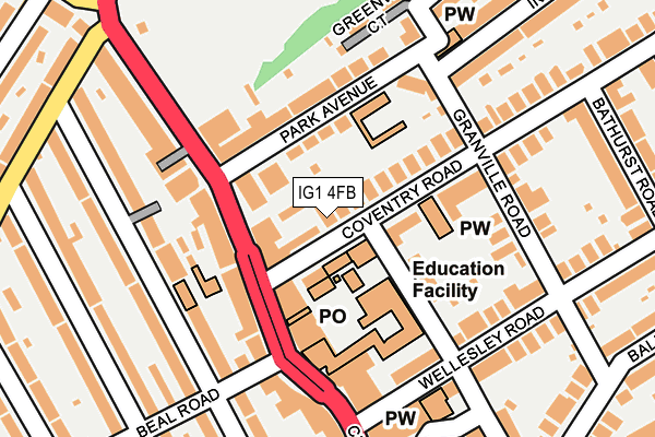
IG1 4FB is located in the Valentines electoral ward, within the London borough of Redbridge and the English Parliamentary constituency of Ilford South. The Sub Integrated Care Board (ICB) Location is NHS North East London ICB - A3A8R and the police force is Metropolitan Police. This postcode has been in use since August 2014.


GetTheData
Source: OS OpenMap – Local (Ordnance Survey)
Source: OS VectorMap District (Ordnance Survey)
Licence: Open Government Licence (requires attribution)
| Easting | 543493 |
| Northing | 186955 |
| Latitude | 51.563224 |
| Longitude | 0.068755 |
GetTheData
Source: Open Postcode Geo
Licence: Open Government Licence
| Country | England |
| Postcode District | IG1 |
➜ See where IG1 is on a map ➜ Where is Ilford? | |
GetTheData
Source: Land Registry Price Paid Data
Licence: Open Government Licence
Elevation or altitude of IG1 4FB as distance above sea level:
| Metres | Feet | |
|---|---|---|
| Elevation | 10m | 33ft |
Elevation is measured from the approximate centre of the postcode, to the nearest point on an OS contour line from OS Terrain 50, which has contour spacing of ten vertical metres.
➜ How high above sea level am I? Find the elevation of your current position using your device's GPS.
GetTheData
Source: Open Postcode Elevation
Licence: Open Government Licence
| Ward | Valentines |
| Constituency | Ilford South |
GetTheData
Source: ONS Postcode Database
Licence: Open Government Licence
| Coventry Road Bathurst Road | Ilford | 72m |
| Coventry Road (Cranbrook Road) | Ilford | 77m |
| Coventry Road (Cranbrook Road) | Ilford | 83m |
| Park Avenue | Ilford | 84m |
| Beal Road (Cranbrook Road) | Ilford | 90m |
| Gants Hill Underground Station | Gants Hill | 1,492m |
| Newbury Park Underground Station | Newbury Park | 2,026m |
| Ilford Station | 0.5km |
| Manor Park Station | 2km |
| Seven Kings Station | 2km |
GetTheData
Source: NaPTAN
Licence: Open Government Licence
Estimated total energy consumption in IG1 4FB by fuel type, 2015.
| Consumption (kWh) | 244,357 |
|---|---|
| Meter count | 12 |
| Mean (kWh/meter) | 20,363 |
| Median (kWh/meter) | 17,500 |
| Consumption (kWh) | 11,095 |
|---|---|
| Meter count | 12 |
| Mean (kWh/meter) | 925 |
| Median (kWh/meter) | 968 |
GetTheData
Source: Postcode level gas estimates: 2015 (experimental)
Source: Postcode level electricity estimates: 2015 (experimental)
Licence: Open Government Licence
GetTheData
Source: ONS Postcode Database
Licence: Open Government Licence


➜ Get more ratings from the Food Standards Agency
GetTheData
Source: Food Standards Agency
Licence: FSA terms & conditions
| Last Collection | |||
|---|---|---|---|
| Location | Mon-Fri | Sat | Distance |
| Cranbrook Road Post Office | 18:30 | 12:45 | 110m |
| Coventry Road | 17:30 | 12:00 | 170m |
| Northbrook Road | 17:00 | 12:00 | 347m |
GetTheData
Source: Dracos
Licence: Creative Commons Attribution-ShareAlike
The below table lists the International Territorial Level (ITL) codes (formerly Nomenclature of Territorial Units for Statistics (NUTS) codes) and Local Administrative Units (LAU) codes for IG1 4FB:
| ITL 1 Code | Name |
|---|---|
| TLI | London |
| ITL 2 Code | Name |
| TLI5 | Outer London - East and North East |
| ITL 3 Code | Name |
| TLI53 | Redbridge and Waltham Forest |
| LAU 1 Code | Name |
| E09000026 | Redbridge |
GetTheData
Source: ONS Postcode Directory
Licence: Open Government Licence
The below table lists the Census Output Area (OA), Lower Layer Super Output Area (LSOA), and Middle Layer Super Output Area (MSOA) for IG1 4FB:
| Code | Name | |
|---|---|---|
| OA | E00019013 | |
| LSOA | E01003781 | Redbridge 026A |
| MSOA | E02000776 | Redbridge 026 |
GetTheData
Source: ONS Postcode Directory
Licence: Open Government Licence
| IG1 4QR | Coventry Road | 33m |
| IG1 4LX | Cranbrook Road | 63m |
| IG1 4RT | Park Avenue | 64m |
| IG1 4LZ | Cranbrook Road | 102m |
| IG1 4TD | Cranbrook Road | 109m |
| IG1 4JU | Morland Road | 113m |
| IG1 4TA | Cranbrook Road | 118m |
| IG1 4RS | Park Avenue | 121m |
| IG1 4JY | Granville Road | 153m |
| IG1 4JT | Wellesley Road | 155m |
GetTheData
Source: Open Postcode Geo; Land Registry Price Paid Data
Licence: Open Government Licence