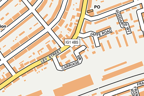
IG1 4BS lies on Ley Street in Ilford. IG1 4BS is located in the Ilford Town electoral ward, within the London borough of Redbridge and the English Parliamentary constituency of Ilford South. The Sub Integrated Care Board (ICB) Location is NHS North East London ICB - A3A8R and the police force is Metropolitan Police. This postcode has been in use since January 1980.


GetTheData
Source: OS OpenMap – Local (Ordnance Survey)
Source: OS VectorMap District (Ordnance Survey)
Licence: Open Government Licence (requires attribution)
| Easting | 544454 |
| Northing | 187038 |
| Latitude | 51.563724 |
| Longitude | 0.082643 |
GetTheData
Source: Open Postcode Geo
Licence: Open Government Licence
| Street | Ley Street |
| Town/City | Ilford |
| Country | England |
| Postcode District | IG1 |
➜ See where IG1 is on a map ➜ Where is Ilford? | |
GetTheData
Source: Land Registry Price Paid Data
Licence: Open Government Licence
Elevation or altitude of IG1 4BS as distance above sea level:
| Metres | Feet | |
|---|---|---|
| Elevation | 10m | 33ft |
Elevation is measured from the approximate centre of the postcode, to the nearest point on an OS contour line from OS Terrain 50, which has contour spacing of ten vertical metres.
➜ How high above sea level am I? Find the elevation of your current position using your device's GPS.
GetTheData
Source: Open Postcode Elevation
Licence: Open Government Licence
| Ward | Ilford Town |
| Constituency | Ilford South |
GetTheData
Source: ONS Postcode Database
Licence: Open Government Licence
| Jaffe Road (Ley Street) | Ilford | 47m |
| Brisbane Road (Ley Street) | Ilford | 61m |
| Vicarage Lane Seven Kings (Ley Street) | Ilford | 179m |
| Christchurch Road (Ig1) (Ley Street) | Ilford | 285m |
| Benton Road (Ley Street) | Ilford | 312m |
| Newbury Park Underground Station | Newbury Park | 1,429m |
| Gants Hill Underground Station | Gants Hill | 1,826m |
| Seven Kings Station | 1km |
| Ilford Station | 1km |
| Goodmayes Station | 2km |
GetTheData
Source: NaPTAN
Licence: Open Government Licence
Estimated total energy consumption in IG1 4BS by fuel type, 2015.
| Consumption (kWh) | 54,778 |
|---|---|
| Meter count | 7 |
| Mean (kWh/meter) | 7,825 |
| Median (kWh/meter) | 4,735 |
GetTheData
Source: Postcode level gas estimates: 2015 (experimental)
Source: Postcode level electricity estimates: 2015 (experimental)
Licence: Open Government Licence
GetTheData
Source: ONS Postcode Database
Licence: Open Government Licence


➜ Get more ratings from the Food Standards Agency
GetTheData
Source: Food Standards Agency
Licence: FSA terms & conditions
| Last Collection | |||
|---|---|---|---|
| Location | Mon-Fri | Sat | Distance |
| Ley Street Post Office | 18:30 | 12:00 | 148m |
| Brisbane Road | 17:30 | 12:00 | 379m |
| Ley Street | 17:45 | 12:30 | 515m |
GetTheData
Source: Dracos
Licence: Creative Commons Attribution-ShareAlike
The below table lists the International Territorial Level (ITL) codes (formerly Nomenclature of Territorial Units for Statistics (NUTS) codes) and Local Administrative Units (LAU) codes for IG1 4BS:
| ITL 1 Code | Name |
|---|---|
| TLI | London |
| ITL 2 Code | Name |
| TLI5 | Outer London - East and North East |
| ITL 3 Code | Name |
| TLI53 | Redbridge and Waltham Forest |
| LAU 1 Code | Name |
| E09000026 | Redbridge |
GetTheData
Source: ONS Postcode Directory
Licence: Open Government Licence
The below table lists the Census Output Area (OA), Lower Layer Super Output Area (LSOA), and Middle Layer Super Output Area (MSOA) for IG1 4BS:
| Code | Name | |
|---|---|---|
| OA | E00018877 | |
| LSOA | E01003758 | Redbridge 023D |
| MSOA | E02000773 | Redbridge 023 |
GetTheData
Source: ONS Postcode Directory
Licence: Open Government Licence
| IG1 4GS | Carriage Mews | 40m |
| IG1 4AA | Ley Street | 67m |
| IG1 4SS | Brisbane Road | 88m |
| IG1 4BN | Ley Street | 147m |
| IG1 4BP | Ley Street | 168m |
| IG1 4HD | Thorold Road | 169m |
| IG1 4HA | Thorold Road | 182m |
| IG1 4AF | Ley Street | 187m |
| IG1 4HE | Thorold Road | 193m |
| IG1 4HB | Thorold Road | 212m |
GetTheData
Source: Open Postcode Geo; Land Registry Price Paid Data
Licence: Open Government Licence