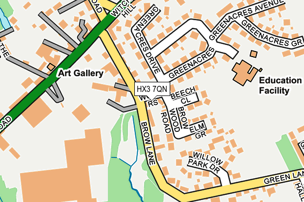
HX3 7QN lies on Brow Wood Rise in Halifax. HX3 7QN is located in the Northowram and Shelf electoral ward, within the metropolitan district of Calderdale and the English Parliamentary constituency of Halifax. The Sub Integrated Care Board (ICB) Location is NHS West Yorkshire ICB - 02T and the police force is West Yorkshire. This postcode has been in use since January 1980.


GetTheData
Source: OS OpenMap – Local (Ordnance Survey)
Source: OS VectorMap District (Ordnance Survey)
Licence: Open Government Licence (requires attribution)
| Easting | 412597 |
| Northing | 428655 |
| Latitude | 53.754110 |
| Longitude | -1.810434 |
GetTheData
Source: Open Postcode Geo
Licence: Open Government Licence
| Street | Brow Wood Rise |
| Town/City | Halifax |
| Country | England |
| Postcode District | HX3 |
➜ See where HX3 is on a map ➜ Where is Shelf? | |
GetTheData
Source: Land Registry Price Paid Data
Licence: Open Government Licence
Elevation or altitude of HX3 7QN as distance above sea level:
| Metres | Feet | |
|---|---|---|
| Elevation | 240m | 787ft |
Elevation is measured from the approximate centre of the postcode, to the nearest point on an OS contour line from OS Terrain 50, which has contour spacing of ten vertical metres.
➜ How high above sea level am I? Find the elevation of your current position using your device's GPS.
GetTheData
Source: Open Postcode Elevation
Licence: Open Government Licence
| Ward | Northowram And Shelf |
| Constituency | Halifax |
GetTheData
Source: ONS Postcode Database
Licence: Open Government Licence
| Wade House Rd Brow Lane (Wade House Road) | Shelf | 168m |
| Wade House Rd Brow Lane (Wade House Road) | Shelf | 190m |
| Witchfield Hill Carr House Lane (Witchfield Hill) | Shelf | 296m |
| Witchfield Hill Carr House Lane (Witchfield Hill) | Shelf | 319m |
| Wade House Rd Wade House Ave (Wade House Road) | Shelf | 348m |
| Low Moor Station | 3.8km |
| Halifax Station | 4.7km |
| Bradford Interchange Station | 5.7km |
GetTheData
Source: NaPTAN
Licence: Open Government Licence
| Percentage of properties with Next Generation Access | 100.0% |
| Percentage of properties with Superfast Broadband | 100.0% |
| Percentage of properties with Ultrafast Broadband | 100.0% |
| Percentage of properties with Full Fibre Broadband | 0.0% |
Superfast Broadband is between 30Mbps and 300Mbps
Ultrafast Broadband is > 300Mbps
| Percentage of properties unable to receive 2Mbps | 0.0% |
| Percentage of properties unable to receive 5Mbps | 0.0% |
| Percentage of properties unable to receive 10Mbps | 0.0% |
| Percentage of properties unable to receive 30Mbps | 0.0% |
GetTheData
Source: Ofcom
Licence: Ofcom Terms of Use (requires attribution)
GetTheData
Source: ONS Postcode Database
Licence: Open Government Licence


➜ Get more ratings from the Food Standards Agency
GetTheData
Source: Food Standards Agency
Licence: FSA terms & conditions
| Last Collection | |||
|---|---|---|---|
| Location | Mon-Fri | Sat | Distance |
| Buttershaw P.o. Box | 17:15 | 11:45 | 1,125m |
| 39 Shelf Moor Road | 17:15 | 11:00 | 1,445m |
| Northowram P.o. Box | 17:00 | 12:00 | 1,928m |
GetTheData
Source: Dracos
Licence: Creative Commons Attribution-ShareAlike
The below table lists the International Territorial Level (ITL) codes (formerly Nomenclature of Territorial Units for Statistics (NUTS) codes) and Local Administrative Units (LAU) codes for HX3 7QN:
| ITL 1 Code | Name |
|---|---|
| TLE | Yorkshire and The Humber |
| ITL 2 Code | Name |
| TLE4 | West Yorkshire |
| ITL 3 Code | Name |
| TLE44 | Calderdale and Kirklees |
| LAU 1 Code | Name |
| E08000033 | Calderdale |
GetTheData
Source: ONS Postcode Directory
Licence: Open Government Licence
The below table lists the Census Output Area (OA), Lower Layer Super Output Area (LSOA), and Middle Layer Super Output Area (MSOA) for HX3 7QN:
| Code | Name | |
|---|---|---|
| OA | E00055129 | |
| LSOA | E01010933 | Calderdale 003C |
| MSOA | E02002246 | Calderdale 003 |
GetTheData
Source: ONS Postcode Directory
Licence: Open Government Licence
| HX3 7QL | Brow Lane | 22m |
| HX3 7QW | Brow Wood Road | 51m |
| HX3 7QR | Beech Close | 78m |
| HX3 7QJ | Brow Lane | 101m |
| HX3 7QP | Elm Grove | 113m |
| HX3 7QT | Green Acres | 134m |
| HX3 7QS | Green Acres Drive | 136m |
| HX3 7TZ | Willow Park Drive | 149m |
| HX3 7PF | Wade House Road | 187m |
| HX3 7QU | Meadow Close | 200m |
GetTheData
Source: Open Postcode Geo; Land Registry Price Paid Data
Licence: Open Government Licence