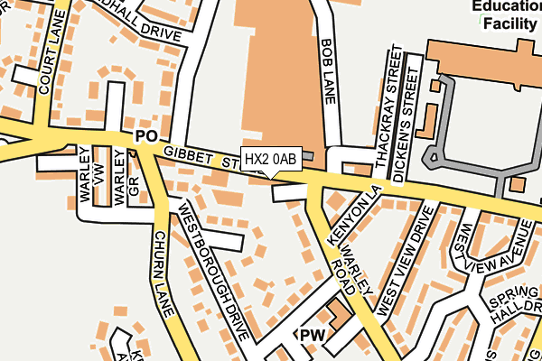
HX2 0AB is located in the Warley electoral ward, within the metropolitan district of Calderdale and the English Parliamentary constituency of Halifax. The Sub Integrated Care Board (ICB) Location is NHS West Yorkshire ICB - 02T and the police force is West Yorkshire. This postcode has been in use since January 1980.


GetTheData
Source: OS OpenMap – Local (Ordnance Survey)
Source: OS VectorMap District (Ordnance Survey)
Licence: Open Government Licence (requires attribution)
| Easting | 406868 |
| Northing | 425184 |
| Latitude | 53.723018 |
| Longitude | -1.897395 |
GetTheData
Source: Open Postcode Geo
Licence: Open Government Licence
| Country | England |
| Postcode District | HX2 |
➜ See where HX2 is on a map | |
GetTheData
Source: Land Registry Price Paid Data
Licence: Open Government Licence
Elevation or altitude of HX2 0AB as distance above sea level:
| Metres | Feet | |
|---|---|---|
| Elevation | 260m | 853ft |
Elevation is measured from the approximate centre of the postcode, to the nearest point on an OS contour line from OS Terrain 50, which has contour spacing of ten vertical metres.
➜ How high above sea level am I? Find the elevation of your current position using your device's GPS.
GetTheData
Source: Open Postcode Elevation
Licence: Open Government Licence
| Ward | Warley |
| Constituency | Halifax |
GetTheData
Source: ONS Postcode Database
Licence: Open Government Licence
| Golden Lion Inn (Warley Road) | Highroad Well | 52m |
| Golden Lion Inn (Warley Road) | Highroad Well | 73m |
| Sandhall Lane (Gibbet Street) | Highroad Well | 75m |
| Golden Lion Inn (Gibbet Street) | Highroad Well | 80m |
| Gibbet Street Thackray St (Gibbet Street) | Highroad Well | 111m |
| Sowerby Bridge Station | 1.8km |
| Halifax Station | 2.9km |
GetTheData
Source: NaPTAN
Licence: Open Government Licence
GetTheData
Source: ONS Postcode Database
Licence: Open Government Licence


➜ Get more ratings from the Food Standards Agency
GetTheData
Source: Food Standards Agency
Licence: FSA terms & conditions
| Last Collection | |||
|---|---|---|---|
| Location | Mon-Fri | Sat | Distance |
| 2 Prospect Avenue | 17:30 | 11:45 | 1,268m |
| Scar Bottom P.o. Box | 17:30 | 11:45 | 1,276m |
| Scarr Bottom Road | 17:15 | 11:45 | 1,515m |
GetTheData
Source: Dracos
Licence: Creative Commons Attribution-ShareAlike
The below table lists the International Territorial Level (ITL) codes (formerly Nomenclature of Territorial Units for Statistics (NUTS) codes) and Local Administrative Units (LAU) codes for HX2 0AB:
| ITL 1 Code | Name |
|---|---|
| TLE | Yorkshire and The Humber |
| ITL 2 Code | Name |
| TLE4 | West Yorkshire |
| ITL 3 Code | Name |
| TLE44 | Calderdale and Kirklees |
| LAU 1 Code | Name |
| E08000033 | Calderdale |
GetTheData
Source: ONS Postcode Directory
Licence: Open Government Licence
The below table lists the Census Output Area (OA), Lower Layer Super Output Area (LSOA), and Middle Layer Super Output Area (MSOA) for HX2 0AB:
| Code | Name | |
|---|---|---|
| OA | E00055434 | |
| LSOA | E01010998 | Calderdale 010C |
| MSOA | E02002253 | Calderdale 010 |
GetTheData
Source: ONS Postcode Directory
Licence: Open Government Licence
| HX2 0AN | Roberts Buildings | 40m |
| HX2 0AL | Gibbet Street | 45m |
| HX2 7QN | Westborough Drive | 105m |
| HX2 0AA | Kenyon Lane | 111m |
| HX2 0AS | Hubert Street | 112m |
| HX2 0AD | Warley Road | 116m |
| HX2 0AT | Thackray Street | 137m |
| HX2 0BE | Warley Road | 142m |
| HX2 7QW | Churn Lane | 145m |
| HX2 0AU | Dickens Street | 162m |
GetTheData
Source: Open Postcode Geo; Land Registry Price Paid Data
Licence: Open Government Licence