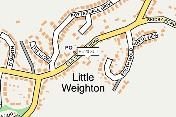
HU20 3UJ lies on The Forge in Little Weighton, Cottingham. HU20 3UJ is located in the Dale electoral ward, within the unitary authority of East Riding of Yorkshire and the English Parliamentary constituency of Haltemprice and Howden. The Sub Integrated Care Board (ICB) Location is NHS Humber and North Yorkshire ICB - 02Y and the police force is Humberside. This postcode has been in use since December 1998.


GetTheData
Source: OS OpenMap – Local (Ordnance Survey)
Source: OS VectorMap District (Ordnance Survey)
Licence: Open Government Licence (requires attribution)
| Easting | 498579 |
| Northing | 433723 |
| Latitude | 53.790496 |
| Longitude | -0.505092 |
GetTheData
Source: Open Postcode Geo
Licence: Open Government Licence
| Street | The Forge |
| Locality | Little Weighton |
| Town/City | Cottingham |
| Country | England |
| Postcode District | HU20 |
➜ See where HU20 is on a map ➜ Where is Little Weighton? | |
GetTheData
Source: Land Registry Price Paid Data
Licence: Open Government Licence
Elevation or altitude of HU20 3UJ as distance above sea level:
| Metres | Feet | |
|---|---|---|
| Elevation | 80m | 262ft |
Elevation is measured from the approximate centre of the postcode, to the nearest point on an OS contour line from OS Terrain 50, which has contour spacing of ten vertical metres.
➜ How high above sea level am I? Find the elevation of your current position using your device's GPS.
GetTheData
Source: Open Postcode Elevation
Licence: Open Government Licence
| Ward | Dale |
| Constituency | Haltemprice And Howden |
GetTheData
Source: ONS Postcode Database
Licence: Open Government Licence
| Little Weighton Old Village Road (Old Village Road) | Little Weighton | 116m |
| Little Weighton Pond (Skidby Road) | Little Weighton | 191m |
| Little Weighton Turning Cir (Rowley Road) | Little Weighton | 485m |
GetTheData
Source: NaPTAN
Licence: Open Government Licence
| Percentage of properties with Next Generation Access | 100.0% |
| Percentage of properties with Superfast Broadband | 100.0% |
| Percentage of properties with Ultrafast Broadband | 100.0% |
| Percentage of properties with Full Fibre Broadband | 100.0% |
Superfast Broadband is between 30Mbps and 300Mbps
Ultrafast Broadband is > 300Mbps
| Percentage of properties unable to receive 2Mbps | 0.0% |
| Percentage of properties unable to receive 5Mbps | 0.0% |
| Percentage of properties unable to receive 10Mbps | 0.0% |
| Percentage of properties unable to receive 30Mbps | 0.0% |
GetTheData
Source: Ofcom
Licence: Ofcom Terms of Use (requires attribution)
GetTheData
Source: ONS Postcode Database
Licence: Open Government Licence
➜ Get more ratings from the Food Standards Agency
GetTheData
Source: Food Standards Agency
Licence: FSA terms & conditions
| Last Collection | |||
|---|---|---|---|
| Location | Mon-Fri | Sat | Distance |
| Little Weighton Post Office | 16:45 | 11:15 | 56m |
| Rowley Road | 16:45 | 11:15 | 507m |
| Skidby Post Office | 16:45 | 11:00 | 2,649m |
GetTheData
Source: Dracos
Licence: Creative Commons Attribution-ShareAlike
The below table lists the International Territorial Level (ITL) codes (formerly Nomenclature of Territorial Units for Statistics (NUTS) codes) and Local Administrative Units (LAU) codes for HU20 3UJ:
| ITL 1 Code | Name |
|---|---|
| TLE | Yorkshire and The Humber |
| ITL 2 Code | Name |
| TLE1 | East Yorkshire and Northern Lincolnshire |
| ITL 3 Code | Name |
| TLE12 | East Riding of Yorkshire |
| LAU 1 Code | Name |
| E06000011 | East Riding of Yorkshire |
GetTheData
Source: ONS Postcode Directory
Licence: Open Government Licence
The below table lists the Census Output Area (OA), Lower Layer Super Output Area (LSOA), and Middle Layer Super Output Area (MSOA) for HU20 3UJ:
| Code | Name | |
|---|---|---|
| OA | E00065433 | |
| LSOA | E01012965 | East Riding of Yorkshire 024B |
| MSOA | E02002707 | East Riding of Yorkshire 024 |
GetTheData
Source: ONS Postcode Directory
Licence: Open Government Licence
| HU20 3US | Old Village Road | 25m |
| HU20 3UQ | South Wold | 85m |
| HU20 3UU | Potterdale Drive | 107m |
| HU20 3XA | The Close | 164m |
| HU20 3UX | Potterdale Drive | 178m |
| HU20 3UL | North View | 218m |
| HU20 3XB | White Gap Road | 250m |
| HU20 3XQ | Rowley Road | 255m |
| HU20 3XG | West Garth | 281m |
| HU20 3UY | Skidby Road | 294m |
GetTheData
Source: Open Postcode Geo; Land Registry Price Paid Data
Licence: Open Government Licence