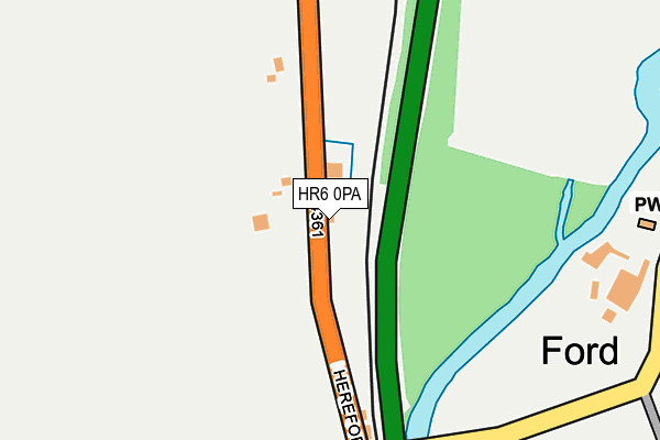
HR6 0PA lies on Railway Cottages in Ford Bridge, Leominster. HR6 0PA is located in the Leominster East electoral ward, within the unitary authority of Herefordshire, County of and the English Parliamentary constituency of North Herefordshire. The Sub Integrated Care Board (ICB) Location is NHS Herefordshire and Worcestershire ICB - 18C and the police force is West Mercia. This postcode has been in use since January 1980.


GetTheData
Source: OS OpenMap – Local (Ordnance Survey)
Source: OS VectorMap District (Ordnance Survey)
Licence: Open Government Licence (requires attribution)
| Easting | 350883 |
| Northing | 255312 |
| Latitude | 52.193845 |
| Longitude | -2.719973 |
GetTheData
Source: Open Postcode Geo
Licence: Open Government Licence
| Street | Railway Cottages |
| Locality | Ford Bridge |
| Town/City | Leominster |
| Country | England |
| Postcode District | HR6 |
➜ See where HR6 is on a map ➜ Where is Wharton? | |
GetTheData
Source: Land Registry Price Paid Data
Licence: Open Government Licence
Elevation or altitude of HR6 0PA as distance above sea level:
| Metres | Feet | |
|---|---|---|
| Elevation | 70m | 230ft |
Elevation is measured from the approximate centre of the postcode, to the nearest point on an OS contour line from OS Terrain 50, which has contour spacing of ten vertical metres.
➜ How high above sea level am I? Find the elevation of your current position using your device's GPS.
GetTheData
Source: Open Postcode Elevation
Licence: Open Government Licence
| Ward | Leominster East |
| Constituency | North Herefordshire |
GetTheData
Source: ONS Postcode Database
Licence: Open Government Licence
| Shelter (B4361 Hereford Road) | Ford | 170m |
| Shelter (B4361 Hereford Road) | Ford | 172m |
| Golf Club (Unclassified Road) | Ford | 296m |
| Golf Club (Unclassified Road) | Ford | 314m |
| Newton Turn (B4361 Hereford Road) | Marlbrook | 1,296m |
| Leominster Station | 3.6km |
GetTheData
Source: NaPTAN
Licence: Open Government Licence
| Percentage of properties with Next Generation Access | 100.0% |
| Percentage of properties with Superfast Broadband | 100.0% |
| Percentage of properties with Ultrafast Broadband | 0.0% |
| Percentage of properties with Full Fibre Broadband | 0.0% |
Superfast Broadband is between 30Mbps and 300Mbps
Ultrafast Broadband is > 300Mbps
| Percentage of properties unable to receive 2Mbps | 0.0% |
| Percentage of properties unable to receive 5Mbps | 0.0% |
| Percentage of properties unable to receive 10Mbps | 0.0% |
| Percentage of properties unable to receive 30Mbps | 0.0% |
GetTheData
Source: Ofcom
Licence: Ofcom Terms of Use (requires attribution)
GetTheData
Source: ONS Postcode Database
Licence: Open Government Licence


➜ Get more ratings from the Food Standards Agency
GetTheData
Source: Food Standards Agency
Licence: FSA terms & conditions
| Last Collection | |||
|---|---|---|---|
| Location | Mon-Fri | Sat | Distance |
| Castlefields | 16:00 | 11:00 | 3,300m |
| Pinsley Road | 16:45 | 11:00 | 3,876m |
| The Mallards | 15:00 | 08:00 | 4,715m |
GetTheData
Source: Dracos
Licence: Creative Commons Attribution-ShareAlike
The below table lists the International Territorial Level (ITL) codes (formerly Nomenclature of Territorial Units for Statistics (NUTS) codes) and Local Administrative Units (LAU) codes for HR6 0PA:
| ITL 1 Code | Name |
|---|---|
| TLG | West Midlands (England) |
| ITL 2 Code | Name |
| TLG1 | Herefordshire, Worcestershire and Warwickshire |
| ITL 3 Code | Name |
| TLG11 | Herefordshire, County of |
| LAU 1 Code | Name |
| E06000019 | Herefordshire, County of |
GetTheData
Source: ONS Postcode Directory
Licence: Open Government Licence
The below table lists the Census Output Area (OA), Lower Layer Super Output Area (LSOA), and Middle Layer Super Output Area (MSOA) for HR6 0PA:
| Code | Name | |
|---|---|---|
| OA | E00070925 | |
| LSOA | E01014045 | Herefordshire 003A |
| MSOA | E02002907 | Herefordshire 003 |
GetTheData
Source: ONS Postcode Directory
Licence: Open Government Licence
| HR6 0NZ | Hereford Road | 50m |
| HR6 0NY | 140m | |
| HR6 0NX | 350m | |
| HR6 0PB | 371m | |
| HR6 0PD | Marlborough Villas | 596m |
| HR6 0PE | 785m | |
| HR6 0NS | 1335m | |
| HR6 0NT | 1400m | |
| HR6 0LL | 1402m | |
| HR6 0NU | 1481m |
GetTheData
Source: Open Postcode Geo; Land Registry Price Paid Data
Licence: Open Government Licence