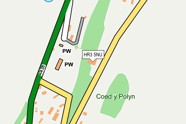
HR3 5NU is in Glasbury, Hereford. HR3 5NU is located in the Gwernyfed electoral ward, within the unitary authority of Powys and the Welsh Parliamentary constituency of Brecon and Radnorshire. The Local Health Board is Powys Teaching and the police force is Dyfed-Powys. This postcode has been in use since January 1980.


GetTheData
Source: OS OpenMap – Local (Ordnance Survey)
Source: OS VectorMap District (Ordnance Survey)
Licence: Open Government Licence (requires attribution)
| Easting | 317829 |
| Northing | 238546 |
| Latitude | 52.039202 |
| Longitude | -3.199391 |
GetTheData
Source: Open Postcode Geo
Licence: Open Government Licence
| Locality | Glasbury |
| Town/City | Hereford |
| Country | Wales |
| Postcode District | HR3 |
➜ See where HR3 is on a map ➜ Where is Glasbury? | |
GetTheData
Source: Land Registry Price Paid Data
Licence: Open Government Licence
Elevation or altitude of HR3 5NU as distance above sea level:
| Metres | Feet | |
|---|---|---|
| Elevation | 120m | 394ft |
Elevation is measured from the approximate centre of the postcode, to the nearest point on an OS contour line from OS Terrain 50, which has contour spacing of ten vertical metres.
➜ How high above sea level am I? Find the elevation of your current position using your device's GPS.
GetTheData
Source: Open Postcode Elevation
Licence: Open Government Licence
| Ward | Gwernyfed |
| Constituency | Brecon And Radnorshire |
GetTheData
Source: ONS Postcode Database
Licence: Open Government Licence
THE OLD STABLES, THE OLD RECTORY, GLASBURY, HEREFORD, HR3 5NU 2021 11 JAN £259,950 |
PENYLAN COTTAGE, GLASBURY, HEREFORD, HR3 5NU 2004 26 MAR £105,000 |
THE OLD RECTORY, GLASBURY, HEREFORD, HR3 5NU 2003 14 APR £391,000 |
WHINMOOR, GLASBURY, HEREFORD, HR3 5NU 1996 6 AUG £92,500 |
GetTheData
Source: HM Land Registry Price Paid Data
Licence: Contains HM Land Registry data © Crown copyright and database right 2025. This data is licensed under the Open Government Licence v3.0.
| Glasbury Bridge (A438) | Glasbury | 610m |
| Glasbury Bridge (A438) | Glasbury | 617m |
| Glasbury House (B4350) | Glasbury | 683m |
| Glasbury House (B4350) | Glasbury | 691m |
| Old Barn Inn (A438) | Three Cocks | 771m |
GetTheData
Source: NaPTAN
Licence: Open Government Licence
| Percentage of properties with Next Generation Access | 100.0% |
| Percentage of properties with Superfast Broadband | 85.7% |
| Percentage of properties with Ultrafast Broadband | 0.0% |
| Percentage of properties with Full Fibre Broadband | 0.0% |
Superfast Broadband is between 30Mbps and 300Mbps
Ultrafast Broadband is > 300Mbps
| Percentage of properties unable to receive 2Mbps | 0.0% |
| Percentage of properties unable to receive 5Mbps | 0.0% |
| Percentage of properties unable to receive 10Mbps | 0.0% |
| Percentage of properties unable to receive 30Mbps | 14.3% |
GetTheData
Source: Ofcom
Licence: Ofcom Terms of Use (requires attribution)
GetTheData
Source: ONS Postcode Database
Licence: Open Government Licence


➜ Get more ratings from the Food Standards Agency
GetTheData
Source: Food Standards Agency
Licence: FSA terms & conditions
| Last Collection | |||
|---|---|---|---|
| Location | Mon-Fri | Sat | Distance |
| Felindre | 16:00 | 10:30 | 2,008m |
| Tregoyd | 16:00 | 08:30 | 2,090m |
| Ffordlas | 09:45 | 09:15 | 2,610m |
GetTheData
Source: Dracos
Licence: Creative Commons Attribution-ShareAlike
The below table lists the International Territorial Level (ITL) codes (formerly Nomenclature of Territorial Units for Statistics (NUTS) codes) and Local Administrative Units (LAU) codes for HR3 5NU:
| ITL 1 Code | Name |
|---|---|
| TLL | Wales |
| ITL 2 Code | Name |
| TLL2 | East Wales |
| ITL 3 Code | Name |
| TLL24 | Powys |
| LAU 1 Code | Name |
| W06000023 | Powys |
GetTheData
Source: ONS Postcode Directory
Licence: Open Government Licence
The below table lists the Census Output Area (OA), Lower Layer Super Output Area (LSOA), and Middle Layer Super Output Area (MSOA) for HR3 5NU:
| Code | Name | |
|---|---|---|
| OA | W00002373 | |
| LSOA | W01000445 | Powys 015C |
| MSOA | W02000111 | Powys 015 |
GetTheData
Source: ONS Postcode Directory
Licence: Open Government Licence
| HR3 5NT | 131m | |
| HR3 5TJ | 435m | |
| HR3 5JY | Old Station Way | 496m |
| HR3 5NH | Dan Y Bryn | 547m |
| HR3 5PE | Twin Oaks | 551m |
| HR3 5PF | Meadow View | 591m |
| HR3 5LL | The Green | 615m |
| HR3 5LJ | 633m | |
| HR3 5NW | The Birches | 675m |
| HR3 5NF | Brookside | 699m |
GetTheData
Source: Open Postcode Geo; Land Registry Price Paid Data
Licence: Open Government Licence