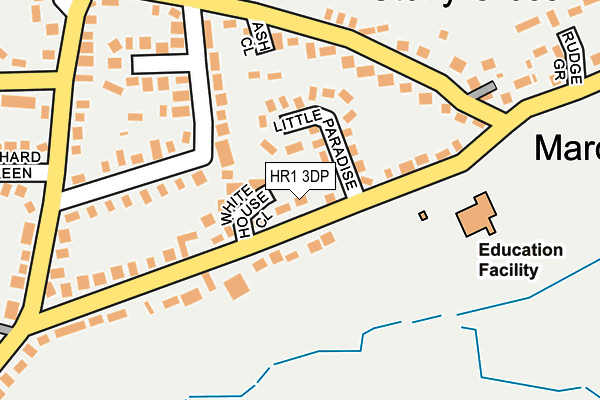
HR1 3DP lies on Walkers Green in Marden, Hereford. HR1 3DP is located in the Sutton Walls electoral ward, within the unitary authority of Herefordshire, County of and the English Parliamentary constituency of North Herefordshire. The Sub Integrated Care Board (ICB) Location is NHS Herefordshire and Worcestershire ICB - 18C and the police force is West Mercia. This postcode has been in use since January 1980.


GetTheData
Source: OS OpenMap – Local (Ordnance Survey)
Source: OS VectorMap District (Ordnance Survey)
Licence: Open Government Licence (requires attribution)
| Easting | 352317 |
| Northing | 247570 |
| Latitude | 52.124373 |
| Longitude | -2.697906 |
GetTheData
Source: Open Postcode Geo
Licence: Open Government Licence
| Street | Walkers Green |
| Locality | Marden |
| Town/City | Hereford |
| Country | England |
| Postcode District | HR1 |
➜ See where HR1 is on a map ➜ Where is Marden? | |
GetTheData
Source: Land Registry Price Paid Data
Licence: Open Government Licence
Elevation or altitude of HR1 3DP as distance above sea level:
| Metres | Feet | |
|---|---|---|
| Elevation | 60m | 197ft |
Elevation is measured from the approximate centre of the postcode, to the nearest point on an OS contour line from OS Terrain 50, which has contour spacing of ten vertical metres.
➜ How high above sea level am I? Find the elevation of your current position using your device's GPS.
GetTheData
Source: Open Postcode Elevation
Licence: Open Government Licence
| Ward | Sutton Walls |
| Constituency | North Herefordshire |
GetTheData
Source: ONS Postcode Database
Licence: Open Government Licence
15, WALKERS GREEN, MARDEN, HEREFORD, HR1 3DP 2015 16 DEC £205,000 |
2011 29 JUL £125,000 |
2011 21 APR £120,000 |
GetTheData
Source: HM Land Registry Price Paid Data
Licence: Contains HM Land Registry data © Crown copyright and database right 2025. This data is licensed under the Open Government Licence v3.0.
| Walkers Green Shops (Paradise Green) | Marden | 102m |
| Walkers Green Shops (Paradise Green) | Marden | 112m |
| Rudge Grove (Marden - Moreton-on-lugg Road) | Marden | 304m |
| The Volunteer Inn (Orchard Green/Walkers Green) | Marden | 308m |
| The Volunteer Inn (Orchard Green/Walkers Green) | Marden | 310m |
GetTheData
Source: NaPTAN
Licence: Open Government Licence
| Percentage of properties with Next Generation Access | 100.0% |
| Percentage of properties with Superfast Broadband | 100.0% |
| Percentage of properties with Ultrafast Broadband | 100.0% |
| Percentage of properties with Full Fibre Broadband | 100.0% |
Superfast Broadband is between 30Mbps and 300Mbps
Ultrafast Broadband is > 300Mbps
| Percentage of properties unable to receive 2Mbps | 0.0% |
| Percentage of properties unable to receive 5Mbps | 0.0% |
| Percentage of properties unable to receive 10Mbps | 0.0% |
| Percentage of properties unable to receive 30Mbps | 0.0% |
GetTheData
Source: Ofcom
Licence: Ofcom Terms of Use (requires attribution)
GetTheData
Source: ONS Postcode Database
Licence: Open Government Licence


➜ Get more ratings from the Food Standards Agency
GetTheData
Source: Food Standards Agency
Licence: FSA terms & conditions
| Last Collection | |||
|---|---|---|---|
| Location | Mon-Fri | Sat | Distance |
| Sutton St Nicholas P.o. | 16:15 | 11:00 | 2,047m |
| The Vauld | 10:15 | 10:15 | 2,058m |
| Lyde | 17:00 | 07:45 | 3,840m |
GetTheData
Source: Dracos
Licence: Creative Commons Attribution-ShareAlike
The below table lists the International Territorial Level (ITL) codes (formerly Nomenclature of Territorial Units for Statistics (NUTS) codes) and Local Administrative Units (LAU) codes for HR1 3DP:
| ITL 1 Code | Name |
|---|---|
| TLG | West Midlands (England) |
| ITL 2 Code | Name |
| TLG1 | Herefordshire, Worcestershire and Warwickshire |
| ITL 3 Code | Name |
| TLG11 | Herefordshire, County of |
| LAU 1 Code | Name |
| E06000019 | Herefordshire, County of |
GetTheData
Source: ONS Postcode Directory
Licence: Open Government Licence
The below table lists the Census Output Area (OA), Lower Layer Super Output Area (LSOA), and Middle Layer Super Output Area (MSOA) for HR1 3DP:
| Code | Name | |
|---|---|---|
| OA | E00071103 | |
| LSOA | E01014082 | Herefordshire 008D |
| MSOA | E02002912 | Herefordshire 008 |
GetTheData
Source: ONS Postcode Directory
Licence: Open Government Licence
| HR1 3DS | White House Close | 52m |
| HR1 3DR | Little Paradise | 72m |
| HR1 3DW | Paradise Green | 76m |
| HR1 3EA | Walkers Green | 123m |
| HR1 3DT | Walkers Green | 128m |
| HR1 3EG | Ash Close | 145m |
| HR1 3DU | Walkers Green | 148m |
| HR1 3DN | Walkers Green | 162m |
| HR1 3DX | 183m | |
| HR1 3EB | Walkers Green | 193m |
GetTheData
Source: Open Postcode Geo; Land Registry Price Paid Data
Licence: Open Government Licence