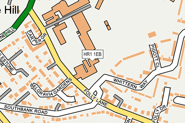
HR1 1EB is located in the College electoral ward, within the unitary authority of Herefordshire, County of and the English Parliamentary constituency of Hereford and South Herefordshire. The Sub Integrated Care Board (ICB) Location is NHS Herefordshire and Worcestershire ICB - 18C and the police force is West Mercia. This postcode has been in use since April 2014.


GetTheData
Source: OS OpenMap – Local (Ordnance Survey)
Source: OS VectorMap District (Ordnance Survey)
Licence: Open Government Licence (requires attribution)
| Easting | 351626 |
| Northing | 241308 |
| Latitude | 52.068027 |
| Longitude | -2.707109 |
GetTheData
Source: Open Postcode Geo
Licence: Open Government Licence
| Country | England |
| Postcode District | HR1 |
➜ See where HR1 is on a map ➜ Where is Hereford? | |
GetTheData
Source: Land Registry Price Paid Data
Licence: Open Government Licence
Elevation or altitude of HR1 1EB as distance above sea level:
| Metres | Feet | |
|---|---|---|
| Elevation | 80m | 262ft |
Elevation is measured from the approximate centre of the postcode, to the nearest point on an OS contour line from OS Terrain 50, which has contour spacing of ten vertical metres.
➜ How high above sea level am I? Find the elevation of your current position using your device's GPS.
GetTheData
Source: Open Postcode Elevation
Licence: Open Government Licence
| Ward | College |
| Constituency | Hereford And South Herefordshire |
GetTheData
Source: ONS Postcode Database
Licence: Open Government Licence
| St Francis Xavier School (Venn's Lane) | Hereford | 90m |
| Royal National College (College Road) | Hereford | 111m |
| St Francis Xavier School (Venn's Lane) | Hereford | 112m |
| Thepoint4 (Venns Lane) | Hereford | 169m |
| Thepoint4 (Venns Lane) | Hereford | 177m |
| Hereford Station | 0.8km |
GetTheData
Source: NaPTAN
Licence: Open Government Licence
GetTheData
Source: ONS Postcode Database
Licence: Open Government Licence


➜ Get more ratings from the Food Standards Agency
GetTheData
Source: Food Standards Agency
Licence: FSA terms & conditions
| Last Collection | |||
|---|---|---|---|
| Location | Mon-Fri | Sat | Distance |
| Folly Lane | 17:00 | 12:00 | 1,082m |
| Commercial Road | 18:30 | 12:00 | 1,093m |
| Commercial Street | 18:30 | 11:30 | 1,233m |
GetTheData
Source: Dracos
Licence: Creative Commons Attribution-ShareAlike
The below table lists the International Territorial Level (ITL) codes (formerly Nomenclature of Territorial Units for Statistics (NUTS) codes) and Local Administrative Units (LAU) codes for HR1 1EB:
| ITL 1 Code | Name |
|---|---|
| TLG | West Midlands (England) |
| ITL 2 Code | Name |
| TLG1 | Herefordshire, Worcestershire and Warwickshire |
| ITL 3 Code | Name |
| TLG11 | Herefordshire, County of |
| LAU 1 Code | Name |
| E06000019 | Herefordshire, County of |
GetTheData
Source: ONS Postcode Directory
Licence: Open Government Licence
The below table lists the Census Output Area (OA), Lower Layer Super Output Area (LSOA), and Middle Layer Super Output Area (MSOA) for HR1 1EB:
| Code | Name | |
|---|---|---|
| OA | E00070598 | |
| LSOA | E01013989 | Herefordshire 012B |
| MSOA | E02002916 | Herefordshire 012 |
GetTheData
Source: ONS Postcode Directory
Licence: Open Government Licence
| HR1 1ED | College Road | 88m |
| HR1 1HG | Queensway | 152m |
| HR1 1BU | Admirals Close | 173m |
| HR1 1AS | Old Barn Court | 176m |
| HR1 1BX | Penn Grove Road | 198m |
| HR1 1HN | College Green | 217m |
| HR1 1AW | Field Grove View | 238m |
| HR1 1AD | Campbell Road | 238m |
| HR1 1DT | Venns Lane | 247m |
| HR1 1EU | Old School Lane | 266m |
GetTheData
Source: Open Postcode Geo; Land Registry Price Paid Data
Licence: Open Government Licence