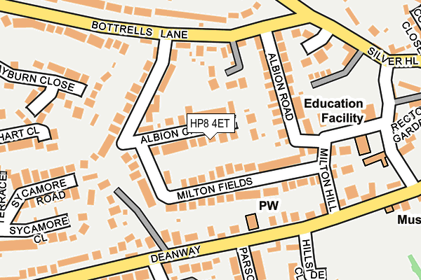
HP8 4ET lies on Albion Crescent in Chalfont St. Giles. HP8 4ET is located in the Chalfont St Giles electoral ward, within the unitary authority of Buckinghamshire and the English Parliamentary constituency of Chesham and Amersham. The Sub Integrated Care Board (ICB) Location is NHS Buckinghamshire, Oxfordshire and Berkshire West ICB - 14Y and the police force is Thames Valley. This postcode has been in use since January 1980.


GetTheData
Source: OS OpenMap – Local (Ordnance Survey)
Source: OS VectorMap District (Ordnance Survey)
Licence: Open Government Licence (requires attribution)
| Easting | 498636 |
| Northing | 193462 |
| Latitude | 51.631333 |
| Longitude | -0.576298 |
GetTheData
Source: Open Postcode Geo
Licence: Open Government Licence
| Street | Albion Crescent |
| Town/City | Chalfont St. Giles |
| Country | England |
| Postcode District | HP8 |
➜ See where HP8 is on a map ➜ Where is Chalfont St Giles? | |
GetTheData
Source: Land Registry Price Paid Data
Licence: Open Government Licence
Elevation or altitude of HP8 4ET as distance above sea level:
| Metres | Feet | |
|---|---|---|
| Elevation | 100m | 328ft |
Elevation is measured from the approximate centre of the postcode, to the nearest point on an OS contour line from OS Terrain 50, which has contour spacing of ten vertical metres.
➜ How high above sea level am I? Find the elevation of your current position using your device's GPS.
GetTheData
Source: Open Postcode Elevation
Licence: Open Government Licence
| Ward | Chalfont St Giles |
| Constituency | Chesham And Amersham |
GetTheData
Source: ONS Postcode Database
Licence: Open Government Licence
| Milton Hill (Dean Way) | Chalfont St Giles | 216m |
| Milton Hill (Dean Way) | Chalfont St Giles | 233m |
| Dean Way | Chalfont St Giles | 257m |
| Dean Way | Chalfont St Giles | 288m |
| High Street | Chalfont St Giles | 418m |
| Seer Green Station | 3.2km |
| Chalfont & Latimer Station | 4.2km |
| Chorleywood Station | 4.8km |
GetTheData
Source: NaPTAN
Licence: Open Government Licence
| Percentage of properties with Next Generation Access | 100.0% |
| Percentage of properties with Superfast Broadband | 100.0% |
| Percentage of properties with Ultrafast Broadband | 100.0% |
| Percentage of properties with Full Fibre Broadband | 0.0% |
Superfast Broadband is between 30Mbps and 300Mbps
Ultrafast Broadband is > 300Mbps
| Median download speed | 24.5Mbps |
| Average download speed | 49.1Mbps |
| Maximum download speed | 200.00Mbps |
| Median upload speed | 3.3Mbps |
| Average upload speed | 5.4Mbps |
| Maximum upload speed | 19.00Mbps |
| Percentage of properties unable to receive 2Mbps | 0.0% |
| Percentage of properties unable to receive 5Mbps | 0.0% |
| Percentage of properties unable to receive 10Mbps | 0.0% |
| Percentage of properties unable to receive 30Mbps | 0.0% |
GetTheData
Source: Ofcom
Licence: Ofcom Terms of Use (requires attribution)
Estimated total energy consumption in HP8 4ET by fuel type, 2015.
| Consumption (kWh) | 398,945 |
|---|---|
| Meter count | 19 |
| Mean (kWh/meter) | 20,997 |
| Median (kWh/meter) | 19,953 |
| Consumption (kWh) | 113,317 |
|---|---|
| Meter count | 20 |
| Mean (kWh/meter) | 5,666 |
| Median (kWh/meter) | 4,542 |
GetTheData
Source: Postcode level gas estimates: 2015 (experimental)
Source: Postcode level electricity estimates: 2015 (experimental)
Licence: Open Government Licence
GetTheData
Source: ONS Postcode Database
Licence: Open Government Licence


➜ Get more ratings from the Food Standards Agency
GetTheData
Source: Food Standards Agency
Licence: FSA terms & conditions
| Last Collection | |||
|---|---|---|---|
| Location | Mon-Fri | Sat | Distance |
| The Chapel | 16:30 | 07:15 | 219m |
| Botterells Lane | 16:30 | 09:15 | 298m |
| St Giles P.o. | 17:15 | 11:45 | 466m |
GetTheData
Source: Dracos
Licence: Creative Commons Attribution-ShareAlike
The below table lists the International Territorial Level (ITL) codes (formerly Nomenclature of Territorial Units for Statistics (NUTS) codes) and Local Administrative Units (LAU) codes for HP8 4ET:
| ITL 1 Code | Name |
|---|---|
| TLJ | South East (England) |
| ITL 2 Code | Name |
| TLJ1 | Berkshire, Buckinghamshire and Oxfordshire |
| ITL 3 Code | Name |
| TLJ13 | Buckinghamshire |
| LAU 1 Code | Name |
| E06000060 | Buckinghamshire |
GetTheData
Source: ONS Postcode Directory
Licence: Open Government Licence
The below table lists the Census Output Area (OA), Lower Layer Super Output Area (LSOA), and Middle Layer Super Output Area (MSOA) for HP8 4ET:
| Code | Name | |
|---|---|---|
| OA | E00089610 | |
| LSOA | E01017761 | Chiltern 010C |
| MSOA | E02003685 | Chiltern 010 |
GetTheData
Source: ONS Postcode Directory
Licence: Open Government Licence
| HP8 4ES | Milton Fields | 71m |
| HP8 4ER | Milton Fields | 108m |
| HP8 4EX | Bottrells Lane | 129m |
| HP8 4EU | Albion Crescent | 130m |
| HP8 4EW | Albion Road | 141m |
| HP8 4JL | Deanway | 149m |
| HP8 4JS | Deanway | 165m |
| HP8 4EP | Milton Fields | 174m |
| HP8 4JR | Deanway | 189m |
| HP8 4EN | Bottrells Lane | 194m |
GetTheData
Source: Open Postcode Geo; Land Registry Price Paid Data
Licence: Open Government Licence