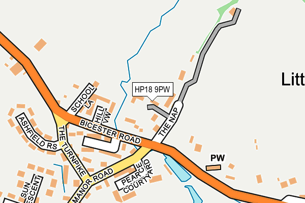
HP18 9PW lies on The Nap in Oakley, Aylesbury. HP18 9PW is located in the Grendon Underwood electoral ward, within the unitary authority of Buckinghamshire and the English Parliamentary constituency of Buckingham. The Sub Integrated Care Board (ICB) Location is NHS Buckinghamshire, Oxfordshire and Berkshire West ICB - 14Y and the police force is Thames Valley. This postcode has been in use since September 2004.


GetTheData
Source: OS OpenMap – Local (Ordnance Survey)
Source: OS VectorMap District (Ordnance Survey)
Licence: Open Government Licence (requires attribution)
| Easting | 464101 |
| Northing | 212406 |
| Latitude | 51.806633 |
| Longitude | -1.071672 |
GetTheData
Source: Open Postcode Geo
Licence: Open Government Licence
| Street | The Nap |
| Locality | Oakley |
| Town/City | Aylesbury |
| Country | England |
| Postcode District | HP18 |
➜ See where HP18 is on a map ➜ Where is Oakley? | |
GetTheData
Source: Land Registry Price Paid Data
Licence: Open Government Licence
Elevation or altitude of HP18 9PW as distance above sea level:
| Metres | Feet | |
|---|---|---|
| Elevation | 90m | 295ft |
Elevation is measured from the approximate centre of the postcode, to the nearest point on an OS contour line from OS Terrain 50, which has contour spacing of ten vertical metres.
➜ How high above sea level am I? Find the elevation of your current position using your device's GPS.
GetTheData
Source: Open Postcode Elevation
Licence: Open Government Licence
| Ward | Grendon Underwood |
| Constituency | Buckingham |
GetTheData
Source: ONS Postcode Database
Licence: Open Government Licence
2022 1 MAR £1,225,000 |
2021 23 JUN £1,150,000 |
NAP HOUSE, THE NAP, OAKLEY, AYLESBURY, HP18 9PW 2007 29 JUN £850,000 |
2002 11 DEC £650,000 |
NAP END, THE NAP, OAKLEY, AYLESBURY, HP18 9PW 2002 7 MAR £325,000 |
NAP HOUSE, THE NAP, OAKLEY, AYLESBURY, HP18 9PW 2000 2 JUN £485,000 |
BOUNDARY COTTAGE, THE NAP, OAKLEY, AYLESBURY, HP18 9PW 1997 17 OCT £190,000 |
NAP END, THE NAP, OAKLEY, AYLESBURY, HP18 9PW 1997 8 AUG £195,000 |
1997 31 JAN £327,500 |
NAP HOUSE, THE NAP, OAKLEY, AYLESBURY, HP18 9PW 1996 28 OCT £280,000 |
GetTheData
Source: HM Land Registry Price Paid Data
Licence: Contains HM Land Registry data © Crown copyright and database right 2025. This data is licensed under the Open Government Licence v3.0.
| Brill Turn (Bicester Road) | Oakley | 322m |
| Brill Turn (Bicester Road) | Oakley | 341m |
| The Royal Oak Ph (Worminghall Road) | Oakley | 355m |
| The Royal Oak Ph (Worminghall Road) | Oakley | 358m |
| College Crescent | Oakley | 773m |
GetTheData
Source: NaPTAN
Licence: Open Government Licence
| Percentage of properties with Next Generation Access | 27.3% |
| Percentage of properties with Superfast Broadband | 27.3% |
| Percentage of properties with Ultrafast Broadband | 0.0% |
| Percentage of properties with Full Fibre Broadband | 0.0% |
Superfast Broadband is between 30Mbps and 300Mbps
Ultrafast Broadband is > 300Mbps
| Median download speed | 8.9Mbps |
| Average download speed | 14.3Mbps |
| Maximum download speed | 55.00Mbps |
| Median upload speed | 1.1Mbps |
| Average upload speed | 2.3Mbps |
| Maximum upload speed | 10.00Mbps |
| Percentage of properties unable to receive 2Mbps | 0.0% |
| Percentage of properties unable to receive 5Mbps | 0.0% |
| Percentage of properties unable to receive 10Mbps | 72.7% |
| Percentage of properties unable to receive 30Mbps | 72.7% |
GetTheData
Source: Ofcom
Licence: Ofcom Terms of Use (requires attribution)
GetTheData
Source: ONS Postcode Database
Licence: Open Government Licence

➜ Get more ratings from the Food Standards Agency
GetTheData
Source: Food Standards Agency
Licence: FSA terms & conditions
| Last Collection | |||
|---|---|---|---|
| Location | Mon-Fri | Sat | Distance |
| Oxford Road | 16:00 | 09:15 | 204m |
| High Street | 16:00 | 10:00 | 2,084m |
| Windmill Street | 16:00 | 09:45 | 2,102m |
GetTheData
Source: Dracos
Licence: Creative Commons Attribution-ShareAlike
The below table lists the International Territorial Level (ITL) codes (formerly Nomenclature of Territorial Units for Statistics (NUTS) codes) and Local Administrative Units (LAU) codes for HP18 9PW:
| ITL 1 Code | Name |
|---|---|
| TLJ | South East (England) |
| ITL 2 Code | Name |
| TLJ1 | Berkshire, Buckinghamshire and Oxfordshire |
| ITL 3 Code | Name |
| TLJ13 | Buckinghamshire |
| LAU 1 Code | Name |
| E06000060 | Buckinghamshire |
GetTheData
Source: ONS Postcode Directory
Licence: Open Government Licence
The below table lists the Census Output Area (OA), Lower Layer Super Output Area (LSOA), and Middle Layer Super Output Area (MSOA) for HP18 9PW:
| Code | Name | |
|---|---|---|
| OA | E00089055 | |
| LSOA | E01017643 | Aylesbury Vale 010B |
| MSOA | E02003661 | Aylesbury Vale 010 |
GetTheData
Source: ONS Postcode Directory
Licence: Open Government Licence
| HP18 9PS | Hill View | 120m |
| HP18 9PN | Brookside | 148m |
| HP18 9PT | School Lane | 165m |
| HP18 9WY | Pearce Courtyard | 198m |
| HP18 9QB | The Turnpike | 199m |
| HP18 9QD | Manor Road | 206m |
| HP18 9QF | Bicester Road | 229m |
| HP18 9QA | Ashfield Rise | 258m |
| HP18 9QG | Bicester Road | 270m |
| HP18 9QT | Manor Road | 306m |
GetTheData
Source: Open Postcode Geo; Land Registry Price Paid Data
Licence: Open Government Licence