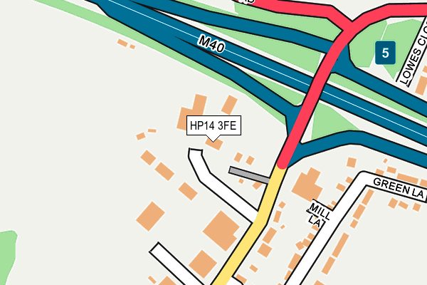
HP14 3FE lies on Ibstone Road in Stokenchurch, High Wycombe. HP14 3FE is located in the Ridgeway West electoral ward, within the unitary authority of Buckinghamshire and the English Parliamentary constituency of Aylesbury. The Sub Integrated Care Board (ICB) Location is NHS Buckinghamshire, Oxfordshire and Berkshire West ICB - 14Y and the police force is Thames Valley. This postcode has been in use since February 2008.


GetTheData
Source: OS OpenMap – Local (Ordnance Survey)
Source: OS VectorMap District (Ordnance Survey)
Licence: Open Government Licence (requires attribution)
| Easting | 475151 |
| Northing | 196238 |
| Latitude | 51.659911 |
| Longitude | -0.914940 |
GetTheData
Source: Open Postcode Geo
Licence: Open Government Licence
| Street | Ibstone Road |
| Locality | Stokenchurch |
| Town/City | High Wycombe |
| Country | England |
| Postcode District | HP14 |
➜ See where HP14 is on a map ➜ Where is Stokenchurch? | |
GetTheData
Source: Land Registry Price Paid Data
Licence: Open Government Licence
Elevation or altitude of HP14 3FE as distance above sea level:
| Metres | Feet | |
|---|---|---|
| Elevation | 230m | 755ft |
Elevation is measured from the approximate centre of the postcode, to the nearest point on an OS contour line from OS Terrain 50, which has contour spacing of ten vertical metres.
➜ How high above sea level am I? Find the elevation of your current position using your device's GPS.
GetTheData
Source: Open Postcode Elevation
Licence: Open Government Licence
| Ward | Ridgeway West |
| Constituency | Aylesbury |
GetTheData
Source: ONS Postcode Database
Licence: Open Government Licence
| Mill Lane (Ibstone Road) | Stokenchurch | 113m |
| Mill Lane (Ibstone Road) | Stokenchurch | 137m |
| Tower Farm (Oxford Road) | Stokenchurch | 217m |
| Tower Farm (Oxford Road) | Stokenchurch | 239m |
| Mill Road (Ibstone Road) | Stokenchurch | 358m |
GetTheData
Source: NaPTAN
Licence: Open Government Licence
GetTheData
Source: ONS Postcode Database
Licence: Open Government Licence


➜ Get more ratings from the Food Standards Agency
GetTheData
Source: Food Standards Agency
Licence: FSA terms & conditions
| Last Collection | |||
|---|---|---|---|
| Location | Mon-Fri | Sat | Distance |
| Mill Road | 16:15 | 09:30 | 198m |
| Stokenchurch P.o. | 16:45 | 11:45 | 891m |
| Marlow Road | 16:30 | 10:30 | 1,842m |
GetTheData
Source: Dracos
Licence: Creative Commons Attribution-ShareAlike
The below table lists the International Territorial Level (ITL) codes (formerly Nomenclature of Territorial Units for Statistics (NUTS) codes) and Local Administrative Units (LAU) codes for HP14 3FE:
| ITL 1 Code | Name |
|---|---|
| TLJ | South East (England) |
| ITL 2 Code | Name |
| TLJ1 | Berkshire, Buckinghamshire and Oxfordshire |
| ITL 3 Code | Name |
| TLJ13 | Buckinghamshire |
| LAU 1 Code | Name |
| E06000060 | Buckinghamshire |
GetTheData
Source: ONS Postcode Directory
Licence: Open Government Licence
The below table lists the Census Output Area (OA), Lower Layer Super Output Area (LSOA), and Middle Layer Super Output Area (MSOA) for HP14 3FE:
| Code | Name | |
|---|---|---|
| OA | E00090378 | |
| LSOA | E01017917 | Wycombe 004C |
| MSOA | E02003699 | Wycombe 004 |
GetTheData
Source: ONS Postcode Directory
Licence: Open Government Licence
| HP14 3TW | Mill Lane | 83m |
| HP14 3BG | Ibstone Road | 133m |
| HP14 3XR | Ibstone Road | 183m |
| HP14 3TP | Mill Road | 224m |
| HP14 3TT | Mill Road | 228m |
| HP14 3SZ | Chiltern Ridge | 254m |
| HP14 3FG | The Haven | 279m |
| HP14 3TX | Green Lane | 279m |
| HP14 3TU | Green Lane | 285m |
| HP14 3TN | Lowes Close | 316m |
GetTheData
Source: Open Postcode Geo; Land Registry Price Paid Data
Licence: Open Government Licence