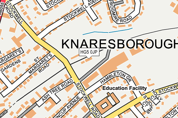
HG5 0JP is located in the Knaresborough West electoral ward, within the unitary authority of North Yorkshire and the English Parliamentary constituency of Harrogate and Knaresborough. The Sub Integrated Care Board (ICB) Location is NHS Humber and North Yorkshire ICB - 42D and the police force is North Yorkshire. This postcode has been in use since January 1980.


GetTheData
Source: OS OpenMap – Local (Ordnance Survey)
Source: OS VectorMap District (Ordnance Survey)
Licence: Open Government Licence (requires attribution)
| Easting | 435220 |
| Northing | 457423 |
| Latitude | 54.011627 |
| Longitude | -1.464050 |
GetTheData
Source: Open Postcode Geo
Licence: Open Government Licence
| Country | England |
| Postcode District | HG5 |
➜ See where HG5 is on a map ➜ Where is Knaresborough? | |
GetTheData
Source: Land Registry Price Paid Data
Licence: Open Government Licence
Elevation or altitude of HG5 0JP as distance above sea level:
| Metres | Feet | |
|---|---|---|
| Elevation | 60m | 197ft |
Elevation is measured from the approximate centre of the postcode, to the nearest point on an OS contour line from OS Terrain 50, which has contour spacing of ten vertical metres.
➜ How high above sea level am I? Find the elevation of your current position using your device's GPS.
GetTheData
Source: Open Postcode Elevation
Licence: Open Government Licence
| Ward | Knaresborough West |
| Constituency | Harrogate And Knaresborough |
GetTheData
Source: ONS Postcode Database
Licence: Open Government Licence
| Castle School (Stockwell Court) | Knaresborough | 183m |
| Castle School (Stockwell Road) | Knaresborough | 186m |
| Stockwell Rd Surgery (Stockwell Avenue) | Knaresborough | 199m |
| Stockwell Rd Surgery (Stockwell Avenue) | Knaresborough | 200m |
| Stockwell Grove | Knaresborough | 312m |
| Knaresborough Station | 0.5km |
| Starbeck Station | 2.8km |
| Harrogate Station | 5.2km |
GetTheData
Source: NaPTAN
Licence: Open Government Licence
GetTheData
Source: ONS Postcode Database
Licence: Open Government Licence


➜ Get more ratings from the Food Standards Agency
GetTheData
Source: Food Standards Agency
Licence: FSA terms & conditions
| Last Collection | |||
|---|---|---|---|
| Location | Mon-Fri | Sat | Distance |
| Market Place (Double Box) | 17:00 | 10:45 | 443m |
| York Place | 16:00 | 10:45 | 619m |
| 21 Princess Ave/Off Chain Lane | 16:45 | 13:30 | 708m |
GetTheData
Source: Dracos
Licence: Creative Commons Attribution-ShareAlike
The below table lists the International Territorial Level (ITL) codes (formerly Nomenclature of Territorial Units for Statistics (NUTS) codes) and Local Administrative Units (LAU) codes for HG5 0JP:
| ITL 1 Code | Name |
|---|---|
| TLE | Yorkshire and The Humber |
| ITL 2 Code | Name |
| TLE2 | North Yorkshire |
| ITL 3 Code | Name |
| TLE22 | North Yorkshire CC |
| LAU 1 Code | Name |
| E07000165 | Harrogate |
GetTheData
Source: ONS Postcode Directory
Licence: Open Government Licence
The below table lists the Census Output Area (OA), Lower Layer Super Output Area (LSOA), and Middle Layer Super Output Area (MSOA) for HG5 0JP:
| Code | Name | |
|---|---|---|
| OA | E00140911 | |
| LSOA | E01027669 | Harrogate 009B |
| MSOA | E02005769 | Harrogate 009 |
GetTheData
Source: ONS Postcode Directory
Licence: Open Government Licence
| HG5 0DB | Hambleton Grove | 111m |
| HG5 0LB | Stockwell View | 121m |
| HG5 0JN | Stockwell Road | 127m |
| HG5 0UB | Ash Tree Road | 149m |
| HG5 0TN | Stockwell Road | 170m |
| HG5 0LA | Stockwell Avenue | 174m |
| HG5 0DD | Hambleton Terrace | 179m |
| HG5 0JY | Stockwell Road | 182m |
| HG5 0JH | Whincup Avenue | 194m |
| HG5 0LE | Frogmire Road | 209m |
GetTheData
Source: Open Postcode Geo; Land Registry Price Paid Data
Licence: Open Government Licence