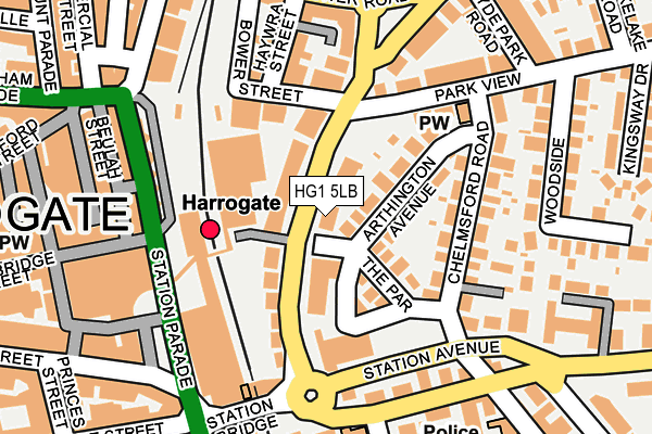
HG1 5LB lies on East Parade in Harrogate. HG1 5LB is located in the Valley Gardens & Central Harrogate electoral ward, within the unitary authority of North Yorkshire and the English Parliamentary constituency of Harrogate and Knaresborough. The Sub Integrated Care Board (ICB) Location is NHS Humber and North Yorkshire ICB - 42D and the police force is North Yorkshire. This postcode has been in use since January 1980.


GetTheData
Source: OS OpenMap – Local (Ordnance Survey)
Source: OS VectorMap District (Ordnance Survey)
Licence: Open Government Licence (requires attribution)
| Easting | 430528 |
| Northing | 455378 |
| Latitude | 53.993561 |
| Longitude | -1.535855 |
GetTheData
Source: Open Postcode Geo
Licence: Open Government Licence
| Street | East Parade |
| Town/City | Harrogate |
| Country | England |
| Postcode District | HG1 |
➜ See where HG1 is on a map ➜ Where is Harrogate? | |
GetTheData
Source: Land Registry Price Paid Data
Licence: Open Government Licence
Elevation or altitude of HG1 5LB as distance above sea level:
| Metres | Feet | |
|---|---|---|
| Elevation | 120m | 394ft |
Elevation is measured from the approximate centre of the postcode, to the nearest point on an OS contour line from OS Terrain 50, which has contour spacing of ten vertical metres.
➜ How high above sea level am I? Find the elevation of your current position using your device's GPS.
GetTheData
Source: Open Postcode Elevation
Licence: Open Government Licence
| Ward | Valley Gardens & Central Harrogate |
| Constituency | Harrogate And Knaresborough |
GetTheData
Source: ONS Postcode Database
Licence: Open Government Licence
| The Odeon (Station Avenue) | Harrogate | 149m |
| The Odeon (Station Avenue) | Harrogate | 154m |
| North Park Road | Harrogate | 188m |
| Hgte Bus Stn Stand 13 (Station Parade) | Harrogate | 193m |
| Asda (Bower Road) | Harrogate | 226m |
| Harrogate Station | 0.1km |
| Hornbeam Park Station | 1.6km |
| Starbeck Station | 2.4km |
GetTheData
Source: NaPTAN
Licence: Open Government Licence
GetTheData
Source: ONS Postcode Database
Licence: Open Government Licence


➜ Get more ratings from the Food Standards Agency
GetTheData
Source: Food Standards Agency
Licence: FSA terms & conditions
| Last Collection | |||
|---|---|---|---|
| Location | Mon-Fri | Sat | Distance |
| Railway Station (Hg) | 18:30 | 13:15 | 116m |
| 53 Knaresborough Road | 17:30 | 13:00 | 145m |
| By Regency Pub East Parade | 18:00 | 13:30 | 269m |
GetTheData
Source: Dracos
Licence: Creative Commons Attribution-ShareAlike
The below table lists the International Territorial Level (ITL) codes (formerly Nomenclature of Territorial Units for Statistics (NUTS) codes) and Local Administrative Units (LAU) codes for HG1 5LB:
| ITL 1 Code | Name |
|---|---|
| TLE | Yorkshire and The Humber |
| ITL 2 Code | Name |
| TLE2 | North Yorkshire |
| ITL 3 Code | Name |
| TLE22 | North Yorkshire CC |
| LAU 1 Code | Name |
| E07000165 | Harrogate |
GetTheData
Source: ONS Postcode Directory
Licence: Open Government Licence
The below table lists the Census Output Area (OA), Lower Layer Super Output Area (LSOA), and Middle Layer Super Output Area (MSOA) for HG1 5LB:
| Code | Name | |
|---|---|---|
| OA | E00140861 | |
| LSOA | E01027656 | Harrogate 019A |
| MSOA | E02005779 | Harrogate 019 |
GetTheData
Source: ONS Postcode Directory
Licence: Open Government Licence
| HG1 5LQ | East Parade | 50m |
| HG1 5NB | Arthington Avenue | 64m |
| HG1 5LH | East Parade | 66m |
| HG1 5ND | The Parade | 81m |
| HG1 5LF | East Parade | 89m |
| HG1 5BQ | Bower Street | 123m |
| HG1 5BG | Haywra Crescent | 123m |
| HG1 5NA | Chelmsford Road | 143m |
| HG1 5LZ | Park View | 148m |
| HG1 5BJ | Haywra Street | 167m |
GetTheData
Source: Open Postcode Geo; Land Registry Price Paid Data
Licence: Open Government Licence