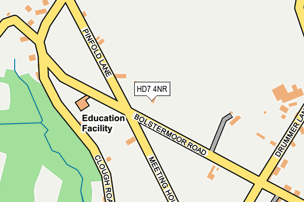
HD7 4NR lies on Bolster Moor Road in Golcar, Huddersfield. HD7 4NR is located in the Colne Valley electoral ward, within the metropolitan district of Kirklees and the English Parliamentary constituency of Colne Valley. The Sub Integrated Care Board (ICB) Location is NHS West Yorkshire ICB - X2C4Y and the police force is West Yorkshire. This postcode has been in use since January 1980.


GetTheData
Source: OS OpenMap – Local (Ordnance Survey)
Source: OS VectorMap District (Ordnance Survey)
Licence: Open Government Licence (requires attribution)
| Easting | 408331 |
| Northing | 415721 |
| Latitude | 53.637942 |
| Longitude | -1.875474 |
GetTheData
Source: Open Postcode Geo
Licence: Open Government Licence
| Street | Bolster Moor Road |
| Locality | Golcar |
| Town/City | Huddersfield |
| Country | England |
| Postcode District | HD7 |
➜ See where HD7 is on a map ➜ Where is Clough Head? | |
GetTheData
Source: Land Registry Price Paid Data
Licence: Open Government Licence
Elevation or altitude of HD7 4NR as distance above sea level:
| Metres | Feet | |
|---|---|---|
| Elevation | 290m | 951ft |
Elevation is measured from the approximate centre of the postcode, to the nearest point on an OS contour line from OS Terrain 50, which has contour spacing of ten vertical metres.
➜ How high above sea level am I? Find the elevation of your current position using your device's GPS.
GetTheData
Source: Open Postcode Elevation
Licence: Open Government Licence
| Ward | Colne Valley |
| Constituency | Colne Valley |
GetTheData
Source: ONS Postcode Database
Licence: Open Government Licence
| Pinfold Lane Primary School (Pinfold Lane) | Bolster Moor | 74m |
| Pinfold Lane Primary School (Pinfold Lane) | Bolster Moor | 76m |
| Bolster Moor Road Drummer Ln (Bolster Moor Road) | Bolster Moor | 239m |
| Bolster Moor Road Drummer Ln (Bolster Moor Road) | Bolster Moor | 241m |
| Pinfold Lane Slaithwaite Gate (Pinfold Lane) | Bolster Moor | 244m |
| Slaithwaite Station | 1.6km |
| Lockwood Station | 5km |
| Marsden Station | 5.3km |
GetTheData
Source: NaPTAN
Licence: Open Government Licence
| Percentage of properties with Next Generation Access | 100.0% |
| Percentage of properties with Superfast Broadband | 100.0% |
| Percentage of properties with Ultrafast Broadband | 0.0% |
| Percentage of properties with Full Fibre Broadband | 0.0% |
Superfast Broadband is between 30Mbps and 300Mbps
Ultrafast Broadband is > 300Mbps
| Percentage of properties unable to receive 2Mbps | 0.0% |
| Percentage of properties unable to receive 5Mbps | 0.0% |
| Percentage of properties unable to receive 10Mbps | 0.0% |
| Percentage of properties unable to receive 30Mbps | 0.0% |
GetTheData
Source: Ofcom
Licence: Ofcom Terms of Use (requires attribution)
Estimated total energy consumption in HD7 4NR by fuel type, 2015.
| Consumption (kWh) | 123,777 |
|---|---|
| Meter count | 6 |
| Mean (kWh/meter) | 20,629 |
| Median (kWh/meter) | 19,142 |
| Consumption (kWh) | 38,954 |
|---|---|
| Meter count | 6 |
| Mean (kWh/meter) | 6,492 |
| Median (kWh/meter) | 5,310 |
GetTheData
Source: Postcode level gas estimates: 2015 (experimental)
Source: Postcode level electricity estimates: 2015 (experimental)
Licence: Open Government Licence
GetTheData
Source: ONS Postcode Database
Licence: Open Government Licence


➜ Get more ratings from the Food Standards Agency
GetTheData
Source: Food Standards Agency
Licence: FSA terms & conditions
| Last Collection | |||
|---|---|---|---|
| Location | Mon-Fri | Sat | Distance |
| West Street | 17:30 | 12:00 | 1,311m |
| Hill Top Slaithwaite | 17:00 | 11:45 | 1,600m |
| Taylor Street | 17:30 | 12:00 | 2,028m |
GetTheData
Source: Dracos
Licence: Creative Commons Attribution-ShareAlike
The below table lists the International Territorial Level (ITL) codes (formerly Nomenclature of Territorial Units for Statistics (NUTS) codes) and Local Administrative Units (LAU) codes for HD7 4NR:
| ITL 1 Code | Name |
|---|---|
| TLE | Yorkshire and The Humber |
| ITL 2 Code | Name |
| TLE4 | West Yorkshire |
| ITL 3 Code | Name |
| TLE44 | Calderdale and Kirklees |
| LAU 1 Code | Name |
| E08000034 | Kirklees |
GetTheData
Source: ONS Postcode Directory
Licence: Open Government Licence
The below table lists the Census Output Area (OA), Lower Layer Super Output Area (LSOA), and Middle Layer Super Output Area (MSOA) for HD7 4NR:
| Code | Name | |
|---|---|---|
| OA | E00056179 | |
| LSOA | E01011151 | Kirklees 036B |
| MSOA | E02002306 | Kirklees 036 |
GetTheData
Source: ONS Postcode Directory
Licence: Open Government Licence
| HD7 4NP | Clough Road | 235m |
| HD7 4NW | Clough Head | 280m |
| HD7 4JT | Drummer Lane | 289m |
| HD7 4LQ | Bolster Grove | 343m |
| HD7 4JU | Bolster Moor Road | 368m |
| HD7 4JX | Clough Road | 393m |
| HD7 4JR | Slades Road | 514m |
| HD7 4NS | Slaithwaite Gate | 534m |
| HD7 4NN | Launds | 538m |
| HD7 4NL | Pike Law Road | 540m |
GetTheData
Source: Open Postcode Geo; Land Registry Price Paid Data
Licence: Open Government Licence