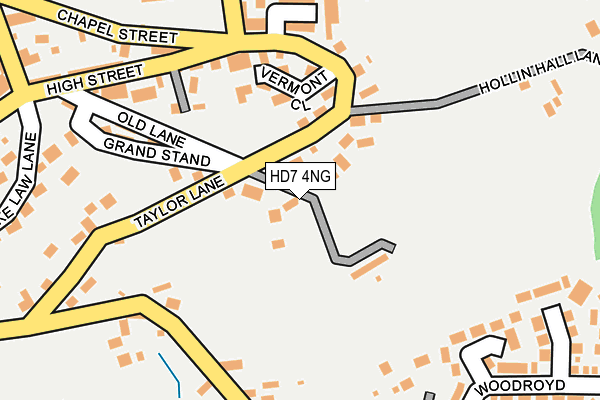
HD7 4NG lies on Upper Haughs in Golcar, Huddersfield. HD7 4NG is located in the Colne Valley electoral ward, within the metropolitan district of Kirklees and the English Parliamentary constituency of Colne Valley. The Sub Integrated Care Board (ICB) Location is NHS West Yorkshire ICB - X2C4Y and the police force is West Yorkshire. This postcode has been in use since January 1980.


GetTheData
Source: OS OpenMap – Local (Ordnance Survey)
Source: OS VectorMap District (Ordnance Survey)
Licence: Open Government Licence (requires attribution)
| Easting | 409084 |
| Northing | 416301 |
| Latitude | 53.643143 |
| Longitude | -1.864069 |
GetTheData
Source: Open Postcode Geo
Licence: Open Government Licence
| Street | Upper Haughs |
| Locality | Golcar |
| Town/City | Huddersfield |
| Country | England |
| Postcode District | HD7 |
➜ See where HD7 is on a map ➜ Where is Scapegoat Hill? | |
GetTheData
Source: Land Registry Price Paid Data
Licence: Open Government Licence
Elevation or altitude of HD7 4NG as distance above sea level:
| Metres | Feet | |
|---|---|---|
| Elevation | 290m | 951ft |
Elevation is measured from the approximate centre of the postcode, to the nearest point on an OS contour line from OS Terrain 50, which has contour spacing of ten vertical metres.
➜ How high above sea level am I? Find the elevation of your current position using your device's GPS.
GetTheData
Source: Open Postcode Elevation
Licence: Open Government Licence
| Ward | Colne Valley |
| Constituency | Colne Valley |
GetTheData
Source: ONS Postcode Database
Licence: Open Government Licence
2023 9 JUN £212,000 |
2010 25 JUN £169,950 |
4, UPPER HAUGHS, GOLCAR, HUDDERSFIELD, HD7 4NG 2007 28 JUN £320,000 |
2005 16 DEC £149,950 |
2001 12 JUN £29,000 |
GetTheData
Source: HM Land Registry Price Paid Data
Licence: Contains HM Land Registry data © Crown copyright and database right 2025. This data is licensed under the Open Government Licence v3.0.
| Chapel Street High St (Chapel Street) | Scapegoat Hill | 194m |
| Slades Rd Swallow Lane (Slades Road) | Scapegoat Hill | 241m |
| Swallow Lane Old La (Swallow Lane) | Golcar | 263m |
| Swallow Lane Old La (Swallow Lane) | Golcar | 268m |
| Slades Rd Swallow Lane (Slades Road) | Scapegoat Hill | 270m |
| Slaithwaite Station | 2.4km |
| Lockwood Station | 4.3km |
| Berry Brow Station | 5.3km |
GetTheData
Source: NaPTAN
Licence: Open Government Licence
| Percentage of properties with Next Generation Access | 100.0% |
| Percentage of properties with Superfast Broadband | 100.0% |
| Percentage of properties with Ultrafast Broadband | 100.0% |
| Percentage of properties with Full Fibre Broadband | 100.0% |
Superfast Broadband is between 30Mbps and 300Mbps
Ultrafast Broadband is > 300Mbps
| Median download speed | 36.6Mbps |
| Average download speed | 31.0Mbps |
| Maximum download speed | 53.06Mbps |
| Median upload speed | 7.5Mbps |
| Average upload speed | 7.6Mbps |
| Maximum upload speed | 18.54Mbps |
| Percentage of properties unable to receive 2Mbps | 0.0% |
| Percentage of properties unable to receive 5Mbps | 0.0% |
| Percentage of properties unable to receive 10Mbps | 0.0% |
| Percentage of properties unable to receive 30Mbps | 0.0% |
GetTheData
Source: Ofcom
Licence: Ofcom Terms of Use (requires attribution)
Estimated total energy consumption in HD7 4NG by fuel type, 2015.
| Consumption (kWh) | 181,651 |
|---|---|
| Meter count | 8 |
| Mean (kWh/meter) | 22,706 |
| Median (kWh/meter) | 19,325 |
| Consumption (kWh) | 27,342 |
|---|---|
| Meter count | 8 |
| Mean (kWh/meter) | 3,418 |
| Median (kWh/meter) | 2,973 |
GetTheData
Source: Postcode level gas estimates: 2015 (experimental)
Source: Postcode level electricity estimates: 2015 (experimental)
Licence: Open Government Licence
GetTheData
Source: ONS Postcode Database
Licence: Open Government Licence


➜ Get more ratings from the Food Standards Agency
GetTheData
Source: Food Standards Agency
Licence: FSA terms & conditions
| Last Collection | |||
|---|---|---|---|
| Location | Mon-Fri | Sat | Distance |
| West Street | 17:30 | 12:00 | 660m |
| Taylor Street | 17:30 | 12:00 | 1,355m |
| Rufford Road | 17:00 | 12:00 | 1,981m |
GetTheData
Source: Dracos
Licence: Creative Commons Attribution-ShareAlike
The below table lists the International Territorial Level (ITL) codes (formerly Nomenclature of Territorial Units for Statistics (NUTS) codes) and Local Administrative Units (LAU) codes for HD7 4NG:
| ITL 1 Code | Name |
|---|---|
| TLE | Yorkshire and The Humber |
| ITL 2 Code | Name |
| TLE4 | West Yorkshire |
| ITL 3 Code | Name |
| TLE44 | Calderdale and Kirklees |
| LAU 1 Code | Name |
| E08000034 | Kirklees |
GetTheData
Source: ONS Postcode Directory
Licence: Open Government Licence
The below table lists the Census Output Area (OA), Lower Layer Super Output Area (LSOA), and Middle Layer Super Output Area (MSOA) for HD7 4NG:
| Code | Name | |
|---|---|---|
| OA | E00056152 | |
| LSOA | E01011151 | Kirklees 036B |
| MSOA | E02002306 | Kirklees 036 |
GetTheData
Source: ONS Postcode Directory
Licence: Open Government Licence
| HD7 4PQ | Taylor Lane | 70m |
| HD7 4PN | Vermont Close | 132m |
| HD7 4PE | Lockwoods Yard | 155m |
| HD7 4NQ | Grand Stand | 162m |
| HD7 4NF | Haughs Green | 162m |
| HD7 4RG | Bonny Clough View | 203m |
| HD7 4ND | Old Lane | 241m |
| HD7 4PF | Hollin Hall Lane | 252m |
| HD7 4PR | Woodroyd | 253m |
| HD7 4NX | Chapel Street | 272m |
GetTheData
Source: Open Postcode Geo; Land Registry Price Paid Data
Licence: Open Government Licence