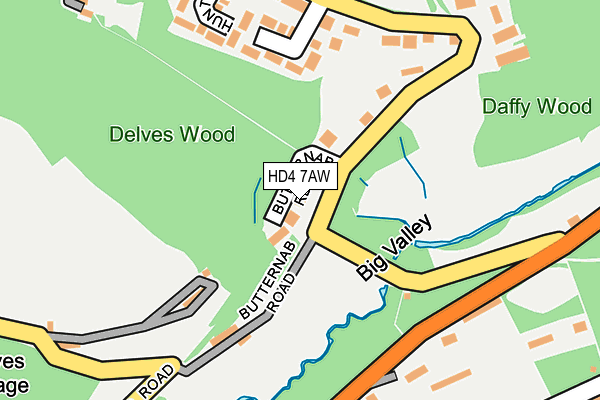
HD4 7AW lies on Butternab Ridge in Huddersfield. HD4 7AW is located in the Crosland Moor and Netherton electoral ward, within the metropolitan district of Kirklees and the English Parliamentary constituency of Colne Valley. The Sub Integrated Care Board (ICB) Location is NHS West Yorkshire ICB - X2C4Y and the police force is West Yorkshire. This postcode has been in use since September 1991.


GetTheData
Source: OS OpenMap – Local (Ordnance Survey)
Source: OS VectorMap District (Ordnance Survey)
Licence: Open Government Licence (requires attribution)
| Easting | 412635 |
| Northing | 413632 |
| Latitude | 53.619081 |
| Longitude | -1.810464 |
GetTheData
Source: Open Postcode Geo
Licence: Open Government Licence
| Street | Butternab Ridge |
| Town/City | Huddersfield |
| Country | England |
| Postcode District | HD4 |
➜ See where HD4 is on a map ➜ Where is Huddersfield? | |
GetTheData
Source: Land Registry Price Paid Data
Licence: Open Government Licence
Elevation or altitude of HD4 7AW as distance above sea level:
| Metres | Feet | |
|---|---|---|
| Elevation | 120m | 394ft |
Elevation is measured from the approximate centre of the postcode, to the nearest point on an OS contour line from OS Terrain 50, which has contour spacing of ten vertical metres.
➜ How high above sea level am I? Find the elevation of your current position using your device's GPS.
GetTheData
Source: Open Postcode Elevation
Licence: Open Government Licence
| Ward | Crosland Moor And Netherton |
| Constituency | Colne Valley |
GetTheData
Source: ONS Postcode Database
Licence: Open Government Licence
2025 5 FEB £690,000 |
2023 10 NOV £585,000 |
2020 1 DEC £500,000 |
2010 9 JUL £365,000 |
3, BUTTERNAB RIDGE, HUDDERSFIELD, HD4 7AW 2004 15 JUL £322,500 |
2003 7 MAR £220,000 |
3, BUTTERNAB RIDGE, HUDDERSFIELD, HD4 7AW 2002 29 NOV £230,000 |
5, BUTTERNAB RIDGE, HUDDERSFIELD, HD4 7AW 1997 12 NOV £50,000 |
1996 20 DEC £142,250 |
GetTheData
Source: HM Land Registry Price Paid Data
Licence: Contains HM Land Registry data © Crown copyright and database right 2025. This data is licensed under the Open Government Licence v3.0.
| Meltham Rd Butternab Road (Meltham Road) | Netherton | 193m |
| Meltham Rd Butternab Road (Meltham Road) | Netherton | 217m |
| Meltham Rd Armitage Road (Meltham Road) | Netherton | 346m |
| Meltham Rd Armitage Road (Meltham Road) | Netherton | 354m |
| Marten Drive Delph Ln (Marten Drive) | Netherton | 383m |
| Berry Brow Station | 1.1km |
| Lockwood Station | 1.9km |
| Honley Station | 2.3km |
GetTheData
Source: NaPTAN
Licence: Open Government Licence
| Percentage of properties with Next Generation Access | 100.0% |
| Percentage of properties with Superfast Broadband | 60.0% |
| Percentage of properties with Ultrafast Broadband | 40.0% |
| Percentage of properties with Full Fibre Broadband | 0.0% |
Superfast Broadband is between 30Mbps and 300Mbps
Ultrafast Broadband is > 300Mbps
| Percentage of properties unable to receive 2Mbps | 0.0% |
| Percentage of properties unable to receive 5Mbps | 0.0% |
| Percentage of properties unable to receive 10Mbps | 0.0% |
| Percentage of properties unable to receive 30Mbps | 40.0% |
GetTheData
Source: Ofcom
Licence: Ofcom Terms of Use (requires attribution)
GetTheData
Source: ONS Postcode Database
Licence: Open Government Licence


➜ Get more ratings from the Food Standards Agency
GetTheData
Source: Food Standards Agency
Licence: FSA terms & conditions
| Last Collection | |||
|---|---|---|---|
| Location | Mon-Fri | Sat | Distance |
| Netherton P.o. Box | 17:15 | 11:15 | 675m |
| 72 Balmoral Avenue | 17:30 | 12:00 | 699m |
| Berry Brow Station | 17:00 | 12:15 | 1,286m |
GetTheData
Source: Dracos
Licence: Creative Commons Attribution-ShareAlike
The below table lists the International Territorial Level (ITL) codes (formerly Nomenclature of Territorial Units for Statistics (NUTS) codes) and Local Administrative Units (LAU) codes for HD4 7AW:
| ITL 1 Code | Name |
|---|---|
| TLE | Yorkshire and The Humber |
| ITL 2 Code | Name |
| TLE4 | West Yorkshire |
| ITL 3 Code | Name |
| TLE44 | Calderdale and Kirklees |
| LAU 1 Code | Name |
| E08000034 | Kirklees |
GetTheData
Source: ONS Postcode Directory
Licence: Open Government Licence
The below table lists the Census Output Area (OA), Lower Layer Super Output Area (LSOA), and Middle Layer Super Output Area (MSOA) for HD4 7AW:
| Code | Name | |
|---|---|---|
| OA | E00055865 | |
| LSOA | E01011086 | Kirklees 050A |
| MSOA | E02002320 | Kirklees 050 |
GetTheData
Source: ONS Postcode Directory
Licence: Open Government Licence
| HD4 7BB | Butternab Road | 137m |
| HD4 7BJ | Butterwood Close | 142m |
| HD4 7AZ | Butternab Road | 178m |
| HD4 7HL | Meltham Road | 207m |
| HD4 7BR | Huntsmans Close | 210m |
| HD4 7BU | Delves | 234m |
| HD4 7BA | Butternab Road | 271m |
| HD4 7BD | Meltham Road | 272m |
| HD4 7LA | Bourn View Road | 280m |
| HD4 7JY | Bourn View Road | 301m |
GetTheData
Source: Open Postcode Geo; Land Registry Price Paid Data
Licence: Open Government Licence