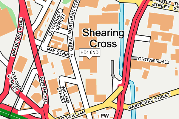
HD1 6ND is located in the Dalton electoral ward, within the metropolitan district of Kirklees and the English Parliamentary constituency of Huddersfield. The Sub Integrated Care Board (ICB) Location is NHS West Yorkshire ICB - X2C4Y and the police force is West Yorkshire. This postcode has been in use since June 1997.


GetTheData
Source: OS OpenMap – Local (Ordnance Survey)
Source: OS VectorMap District (Ordnance Survey)
Licence: Open Government Licence (requires attribution)
| Easting | 414722 |
| Northing | 417390 |
| Latitude | 53.652804 |
| Longitude | -1.778737 |
GetTheData
Source: Open Postcode Geo
Licence: Open Government Licence
| Country | England |
| Postcode District | HD1 |
➜ See where HD1 is on a map ➜ Where is Huddersfield? | |
GetTheData
Source: Land Registry Price Paid Data
Licence: Open Government Licence
Elevation or altitude of HD1 6ND as distance above sea level:
| Metres | Feet | |
|---|---|---|
| Elevation | 70m | 230ft |
Elevation is measured from the approximate centre of the postcode, to the nearest point on an OS contour line from OS Terrain 50, which has contour spacing of ten vertical metres.
➜ How high above sea level am I? Find the elevation of your current position using your device's GPS.
GetTheData
Source: Open Postcode Elevation
Licence: Open Government Licence
| Ward | Dalton |
| Constituency | Huddersfield |
GetTheData
Source: ONS Postcode Database
Licence: Open Government Licence
| Leeds Rd Old Leeds Road (Leeds Road) | Huddersfield Town Centre | 221m |
| Leeds Rd Gasworks Street (Leeds Road) | Huddersfield Town Centre | 227m |
| Northgate Alder Street (Leeds Road) | Huddersfield Town Centre | 231m |
| Oxford St Bradford Road (Oxford Street) | Huddersfield Town Centre | 276m |
| Leeds Rd Thistle Street (Leeds Road) | Bradley Mills | 325m |
| Huddersfield Station | 0.6km |
| Lockwood Station | 2.5km |
| Deighton Station | 2.5km |
GetTheData
Source: NaPTAN
Licence: Open Government Licence
GetTheData
Source: ONS Postcode Database
Licence: Open Government Licence


➜ Get more ratings from the Food Standards Agency
GetTheData
Source: Food Standards Agency
Licence: FSA terms & conditions
| Last Collection | |||
|---|---|---|---|
| Location | Mon-Fri | Sat | Distance |
| 1 Moorfield Road | 18:30 | 11:45 | 147m |
| 313-315 Leeds Road | 18:30 | 11:45 | 338m |
| Hillhouse | 18:30 | 11:45 | 338m |
GetTheData
Source: Dracos
Licence: Creative Commons Attribution-ShareAlike
The below table lists the International Territorial Level (ITL) codes (formerly Nomenclature of Territorial Units for Statistics (NUTS) codes) and Local Administrative Units (LAU) codes for HD1 6ND:
| ITL 1 Code | Name |
|---|---|
| TLE | Yorkshire and The Humber |
| ITL 2 Code | Name |
| TLE4 | West Yorkshire |
| ITL 3 Code | Name |
| TLE44 | Calderdale and Kirklees |
| LAU 1 Code | Name |
| E08000034 | Kirklees |
GetTheData
Source: ONS Postcode Directory
Licence: Open Government Licence
The below table lists the Census Output Area (OA), Lower Layer Super Output Area (LSOA), and Middle Layer Super Output Area (MSOA) for HD1 6ND:
| Code | Name | |
|---|---|---|
| OA | E00055982 | |
| LSOA | E01011107 | Kirklees 029D |
| MSOA | E02002299 | Kirklees 029 |
GetTheData
Source: ONS Postcode Directory
Licence: Open Government Licence
| HD1 6BL | Ray Street | 78m |
| HD1 6BN | Lower Viaduct Street | 142m |
| HD1 6BG | William Street | 165m |
| HD1 6BE | Lower Fitzwilliam Street | 177m |
| HD1 6BA | Lower Fitzwilliam Street | 193m |
| HD1 6HY | Bradford Road | 199m |
| HD1 6HZ | Alder Street | 207m |
| HD1 6AY | Great Northern Street | 221m |
| HD1 6AR | Northgate | 223m |
| HD1 6AS | Lower Fitzwilliam Street | 224m |
GetTheData
Source: Open Postcode Geo; Land Registry Price Paid Data
Licence: Open Government Licence