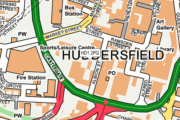
HD1 2PQ is located in the Newsome electoral ward, within the metropolitan district of Kirklees and the English Parliamentary constituency of Huddersfield. The Sub Integrated Care Board (ICB) Location is NHS West Yorkshire ICB - X2C4Y and the police force is West Yorkshire. This postcode has been in use since December 1999.


GetTheData
Source: OS OpenMap – Local (Ordnance Survey)
Source: OS VectorMap District (Ordnance Survey)
Licence: Open Government Licence (requires attribution)
| Easting | 414318 |
| Northing | 416396 |
| Latitude | 53.643881 |
| Longitude | -1.784895 |
GetTheData
Source: Open Postcode Geo
Licence: Open Government Licence
| Country | England |
| Postcode District | HD1 |
➜ See where HD1 is on a map ➜ Where is Huddersfield? | |
GetTheData
Source: Land Registry Price Paid Data
Licence: Open Government Licence
Elevation or altitude of HD1 2PQ as distance above sea level:
| Metres | Feet | |
|---|---|---|
| Elevation | 100m | 328ft |
Elevation is measured from the approximate centre of the postcode, to the nearest point on an OS contour line from OS Terrain 50, which has contour spacing of ten vertical metres.
➜ How high above sea level am I? Find the elevation of your current position using your device's GPS.
GetTheData
Source: Open Postcode Elevation
Licence: Open Government Licence
| Ward | Newsome |
| Constituency | Huddersfield |
GetTheData
Source: ONS Postcode Database
Licence: Open Government Licence
| High Street | Huddersfield Town Centre | 96m |
| High Street | Huddersfield Town Centre | 98m |
| Market Street | Huddersfield Town Centre | 130m |
| Market Street | Huddersfield Town Centre | 131m |
| Peel Street | Huddersfield Town Centre | 166m |
| Huddersfield Station | 0.5km |
| Lockwood Station | 1.5km |
| Berry Brow Station | 2.6km |
GetTheData
Source: NaPTAN
Licence: Open Government Licence
GetTheData
Source: ONS Postcode Database
Licence: Open Government Licence


➜ Get more ratings from the Food Standards Agency
GetTheData
Source: Food Standards Agency
Licence: FSA terms & conditions
| Last Collection | |||
|---|---|---|---|
| Location | Mon-Fri | Sat | Distance |
| King Street | 18:30 | 12:15 | 114m |
| Market Street | 18:30 | 12:30 | 171m |
| Bus Station | 18:30 | 12:00 | 195m |
GetTheData
Source: Dracos
Licence: Creative Commons Attribution-ShareAlike
The below table lists the International Territorial Level (ITL) codes (formerly Nomenclature of Territorial Units for Statistics (NUTS) codes) and Local Administrative Units (LAU) codes for HD1 2PQ:
| ITL 1 Code | Name |
|---|---|
| TLE | Yorkshire and The Humber |
| ITL 2 Code | Name |
| TLE4 | West Yorkshire |
| ITL 3 Code | Name |
| TLE44 | Calderdale and Kirklees |
| LAU 1 Code | Name |
| E08000034 | Kirklees |
GetTheData
Source: ONS Postcode Directory
Licence: Open Government Licence
The below table lists the Census Output Area (OA), Lower Layer Super Output Area (LSOA), and Middle Layer Super Output Area (MSOA) for HD1 2PQ:
| Code | Name | |
|---|---|---|
| OA | E00056549 | |
| LSOA | E01011229 | Kirklees 042D |
| MSOA | E02002312 | Kirklees 042 |
GetTheData
Source: ONS Postcode Directory
Licence: Open Government Licence
| HD1 2PJ | New Street | 48m |
| HD1 2LE | High Street | 114m |
| HD1 2BW | New Street | 141m |
| HD1 2SN | Ramsden Street | 163m |
| HD1 2BQ | New Street | 176m |
| HD1 3HJ | Manchester Road | 216m |
| HD1 2NS | Outcote Bank | 224m |
| HD1 3EB | Chapel Hill | 228m |
| HD1 2QD | King Street | 288m |
| HD1 4BU | Old South Street | 293m |
GetTheData
Source: Open Postcode Geo; Land Registry Price Paid Data
Licence: Open Government Licence