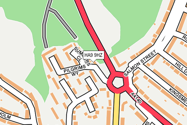
HA9 9HZ lies on Pilgrims Way in Wembley. HA9 9HZ is located in the Barnhill electoral ward, within the London borough of Brent and the English Parliamentary constituency of Brent North. The Sub Integrated Care Board (ICB) Location is NHS North West London ICB - W2U3Z and the police force is Metropolitan Police. This postcode has been in use since May 1994.


GetTheData
Source: OS OpenMap – Local (Ordnance Survey)
Source: OS VectorMap District (Ordnance Survey)
Licence: Open Government Licence (requires attribution)
| Easting | 519790 |
| Northing | 187197 |
| Latitude | 51.570929 |
| Longitude | -0.272914 |
GetTheData
Source: Open Postcode Geo
Licence: Open Government Licence
| Street | Pilgrims Way |
| Town/City | Wembley |
| Country | England |
| Postcode District | HA9 |
➜ See where HA9 is on a map ➜ Where is Wembley? | |
GetTheData
Source: Land Registry Price Paid Data
Licence: Open Government Licence
Elevation or altitude of HA9 9HZ as distance above sea level:
| Metres | Feet | |
|---|---|---|
| Elevation | 60m | 197ft |
Elevation is measured from the approximate centre of the postcode, to the nearest point on an OS contour line from OS Terrain 50, which has contour spacing of ten vertical metres.
➜ How high above sea level am I? Find the elevation of your current position using your device's GPS.
GetTheData
Source: Open Postcode Elevation
Licence: Open Government Licence
| Ward | Barnhill |
| Constituency | Brent North |
GetTheData
Source: ONS Postcode Database
Licence: Open Government Licence
| Wembley Park The Paddocks (Salmon Street) | Kingsbury | 101m |
| Greenhill Way Lycee International | Wembley Park | 448m |
| Greenhill Way Lycee International | Wembley Park | 450m |
| Lycee International De Londres | Wembley Park | 565m |
| Lycee International Kings Drive | Wembley Park | 601m |
| Wembley Park Underground Station | Wembley Park | 965m |
| Wembley Stadium Station | 2km |
| North Wembley Station | 2.3km |
| South Kenton Station | 2.5km |
GetTheData
Source: NaPTAN
Licence: Open Government Licence
| Percentage of properties with Next Generation Access | 100.0% |
| Percentage of properties with Superfast Broadband | 100.0% |
| Percentage of properties with Ultrafast Broadband | 100.0% |
| Percentage of properties with Full Fibre Broadband | 0.0% |
Superfast Broadband is between 30Mbps and 300Mbps
Ultrafast Broadband is > 300Mbps
| Percentage of properties unable to receive 2Mbps | 0.0% |
| Percentage of properties unable to receive 5Mbps | 0.0% |
| Percentage of properties unable to receive 10Mbps | 0.0% |
| Percentage of properties unable to receive 30Mbps | 0.0% |
GetTheData
Source: Ofcom
Licence: Ofcom Terms of Use (requires attribution)
GetTheData
Source: ONS Postcode Database
Licence: Open Government Licence


➜ Get more ratings from the Food Standards Agency
GetTheData
Source: Food Standards Agency
Licence: FSA terms & conditions
| Last Collection | |||
|---|---|---|---|
| Location | Mon-Fri | Sat | Distance |
| Salmon Street | 17:30 | 12:00 | 164m |
| Glenwood Grove | 17:30 | 12:00 | 412m |
| Deanscroft Avenue | 17:30 | 12:00 | 415m |
GetTheData
Source: Dracos
Licence: Creative Commons Attribution-ShareAlike
The below table lists the International Territorial Level (ITL) codes (formerly Nomenclature of Territorial Units for Statistics (NUTS) codes) and Local Administrative Units (LAU) codes for HA9 9HZ:
| ITL 1 Code | Name |
|---|---|
| TLI | London |
| ITL 2 Code | Name |
| TLI7 | Outer London - West and North West |
| ITL 3 Code | Name |
| TLI72 | Brent |
| LAU 1 Code | Name |
| E09000005 | Brent |
GetTheData
Source: ONS Postcode Directory
Licence: Open Government Licence
The below table lists the Census Output Area (OA), Lower Layer Super Output Area (LSOA), and Middle Layer Super Output Area (MSOA) for HA9 9HZ:
| Code | Name | |
|---|---|---|
| OA | E00002360 | |
| LSOA | E01000481 | Brent 009B |
| MSOA | E02000101 | Brent 009 |
GetTheData
Source: ONS Postcode Directory
Licence: Open Government Licence
| HA9 9JH | Summers Close | 68m |
| NW9 8NH | Salmon Street | 71m |
| HA9 9JD | Kings Drive | 77m |
| HA9 9HJ | The Paddocks | 107m |
| NW9 8PX | Salmon Street | 138m |
| HA9 9HW | Swinton Close | 141m |
| HA9 9JJ | Saltcroft Close | 152m |
| HA9 9HQ | The Paddocks | 158m |
| HA9 9JB | Kings Drive | 175m |
| NW9 8NJ | Salmon Street | 189m |
GetTheData
Source: Open Postcode Geo; Land Registry Price Paid Data
Licence: Open Government Licence