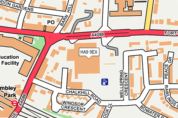
HA9 9EX is located in the Barnhill electoral ward, within the London borough of Brent and the English Parliamentary constituency of Brent North. The Sub Integrated Care Board (ICB) Location is NHS North West London ICB - W2U3Z and the police force is Metropolitan Police. This postcode has been in use since June 1999.


GetTheData
Source: OS OpenMap – Local (Ordnance Survey)
Source: OS VectorMap District (Ordnance Survey)
Licence: Open Government Licence (requires attribution)
| Easting | 519623 |
| Northing | 186500 |
| Latitude | 51.564698 |
| Longitude | -0.275584 |
GetTheData
Source: Open Postcode Geo
Licence: Open Government Licence
| Country | England |
| Postcode District | HA9 |
➜ See where HA9 is on a map ➜ Where is Wembley? | |
GetTheData
Source: Land Registry Price Paid Data
Licence: Open Government Licence
Elevation or altitude of HA9 9EX as distance above sea level:
| Metres | Feet | |
|---|---|---|
| Elevation | 50m | 164ft |
Elevation is measured from the approximate centre of the postcode, to the nearest point on an OS contour line from OS Terrain 50, which has contour spacing of ten vertical metres.
➜ How high above sea level am I? Find the elevation of your current position using your device's GPS.
GetTheData
Source: Open Postcode Elevation
Licence: Open Government Licence
| Ward | Barnhill |
| Constituency | Brent North |
GetTheData
Source: ONS Postcode Database
Licence: Open Government Licence
| Lycee International Kings Drive | Wembley Park | 70m |
| Wembley Park | Wembley Park | 139m |
| Lycee International Kings Drive | Wembley Park | 152m |
| Lycee International De Londres | Wembley Park | 153m |
| Wembley Park | Wembley Park | 175m |
| Wembley Park Underground Station | Wembley Park | 305m |
| Preston Road Underground Station | Preston | 1,577m |
| Wembley Central Underground Station | Wembley | 2,019m |
| Wembley Stadium Station | 1.3km |
| North Wembley Station | 2km |
| Wembley Central Station | 2km |
GetTheData
Source: NaPTAN
Licence: Open Government Licence
GetTheData
Source: ONS Postcode Database
Licence: Open Government Licence


➜ Get more ratings from the Food Standards Agency
GetTheData
Source: Food Standards Agency
Licence: FSA terms & conditions
| Last Collection | |||
|---|---|---|---|
| Location | Mon-Fri | Sat | Distance |
| Empire Court | 18:15 | 12:30 | 383m |
| Deanscroft Avenue | 17:30 | 12:00 | 666m |
| Salmon Street | 17:30 | 12:00 | 670m |
GetTheData
Source: Dracos
Licence: Creative Commons Attribution-ShareAlike
The below table lists the International Territorial Level (ITL) codes (formerly Nomenclature of Territorial Units for Statistics (NUTS) codes) and Local Administrative Units (LAU) codes for HA9 9EX:
| ITL 1 Code | Name |
|---|---|
| TLI | London |
| ITL 2 Code | Name |
| TLI7 | Outer London - West and North West |
| ITL 3 Code | Name |
| TLI72 | Brent |
| LAU 1 Code | Name |
| E09000005 | Brent |
GetTheData
Source: ONS Postcode Directory
Licence: Open Government Licence
The below table lists the Census Output Area (OA), Lower Layer Super Output Area (LSOA), and Middle Layer Super Output Area (MSOA) for HA9 9EX:
| Code | Name | |
|---|---|---|
| OA | E00002370 | |
| LSOA | E01000482 | Brent 009C |
| MSOA | E02000101 | Brent 009 |
GetTheData
Source: ONS Postcode Directory
Licence: Open Government Licence
| HA9 9RJ | Forty Lane | 114m |
| HA9 9FD | Chalkhill Road | 119m |
| HA9 9ES | Kings Drive | 120m |
| HA9 9JU | Barn Hill | 137m |
| HA9 9AL | Chalkhill Road | 138m |
| HA9 9UZ | Wellspring Crescent | 140m |
| HA9 9UR | Forty Lane | 149m |
| HA9 9AJ | Chalkhill Road | 158m |
| HA9 9UB | Wellspring Crescent | 158m |
| HA9 9AN | Windsor Crescent | 161m |
GetTheData
Source: Open Postcode Geo; Land Registry Price Paid Data
Licence: Open Government Licence