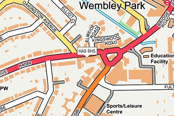
HA9 8HS is located in the Wembley Hill electoral ward, within the London borough of Brent and the English Parliamentary constituency of Brent Central. The Sub Integrated Care Board (ICB) Location is NHS North West London ICB - W2U3Z and the police force is Metropolitan Police. This postcode has been in use since October 2015.


GetTheData
Source: OS OpenMap – Local (Ordnance Survey)
Source: OS VectorMap District (Ordnance Survey)
Licence: Open Government Licence (requires attribution)
| Easting | 519096 |
| Northing | 186159 |
| Latitude | 51.561745 |
| Longitude | -0.283298 |
GetTheData
Source: Open Postcode Geo
Licence: Open Government Licence
| Country | England |
| Postcode District | HA9 |
➜ See where HA9 is on a map ➜ Where is Wembley? | |
GetTheData
Source: Land Registry Price Paid Data
Licence: Open Government Licence
Elevation or altitude of HA9 8HS as distance above sea level:
| Metres | Feet | |
|---|---|---|
| Elevation | 40m | 131ft |
Elevation is measured from the approximate centre of the postcode, to the nearest point on an OS contour line from OS Terrain 50, which has contour spacing of ten vertical metres.
➜ How high above sea level am I? Find the elevation of your current position using your device's GPS.
GetTheData
Source: Open Postcode Elevation
Licence: Open Government Licence
| Ward | Wembley Hill |
| Constituency | Brent Central |
GetTheData
Source: ONS Postcode Database
Licence: Open Government Licence
| Empire Way (Wembley Park Drive) | Wembley Park | 9m |
| Empire Way (Wembley Park Drive) | Wembley Park | 82m |
| Fulton Road (Empire Way) | Wembley Park | 133m |
| Fulton Road | Wembley Park | 149m |
| Manor Drive (Ha9) | Wembley Park | 193m |
| Wembley Park Underground Station | Wembley Park | 323m |
| Preston Road Underground Station | Preston | 1,401m |
| Wembley Central Underground Station | Wembley | 1,409m |
| North Wembley Underground Station | North Wembley | 1,438m |
| Wembley Stadium Station | 0.8km |
| Wembley Central Station | 1.4km |
| North Wembley Station | 1.4km |
GetTheData
Source: NaPTAN
Licence: Open Government Licence
GetTheData
Source: ONS Postcode Database
Licence: Open Government Licence


➜ Get more ratings from the Food Standards Agency
GetTheData
Source: Food Standards Agency
Licence: FSA terms & conditions
| Last Collection | |||
|---|---|---|---|
| Location | Mon-Fri | Sat | Distance |
| Manor Drive | 17:00 | 12:15 | 135m |
| Empire Way | 17:00 | 12:45 | 264m |
| 116 Wembley Hill Road | 17:00 | 12:15 | 569m |
GetTheData
Source: Dracos
Licence: Creative Commons Attribution-ShareAlike
The below table lists the International Territorial Level (ITL) codes (formerly Nomenclature of Territorial Units for Statistics (NUTS) codes) and Local Administrative Units (LAU) codes for HA9 8HS:
| ITL 1 Code | Name |
|---|---|
| TLI | London |
| ITL 2 Code | Name |
| TLI7 | Outer London - West and North West |
| ITL 3 Code | Name |
| TLI72 | Brent |
| LAU 1 Code | Name |
| E09000005 | Brent |
GetTheData
Source: ONS Postcode Directory
Licence: Open Government Licence
The below table lists the Census Output Area (OA), Lower Layer Super Output Area (LSOA), and Middle Layer Super Output Area (MSOA) for HA9 8HS:
| Code | Name | |
|---|---|---|
| OA | E00003000 | |
| LSOA | E01033457 | Brent 017G |
| MSOA | E02000109 | Brent 017 |
GetTheData
Source: ONS Postcode Directory
Licence: Open Government Licence
| HA9 8HP | Wembley Park Drive | 18m |
| HA9 8HF | Wembley Park Drive | 29m |
| HA9 8HG | Wembley Park Drive | 64m |
| HA9 0RQ | Empire Parade | 66m |
| HA9 0RS | Empire Way | 79m |
| HA9 8HW | Wembley Park Drive | 88m |
| HA9 8JB | Elmside Road | 106m |
| HA9 8DJ | Manor Drive | 126m |
| HA9 8HQ | Wembley Park Drive | 135m |
| HA9 8HX | Oakington Avenue | 140m |
GetTheData
Source: Open Postcode Geo; Land Registry Price Paid Data
Licence: Open Government Licence