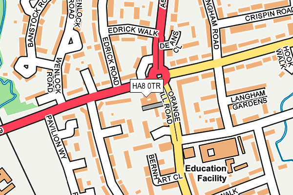
HA8 0TR is located in the Burnt Oak electoral ward, within the London borough of Barnet and the English Parliamentary constituency of Hendon. The Sub Integrated Care Board (ICB) Location is NHS North Central London ICB - 93C and the police force is Metropolitan Police. This postcode has been in use since January 1980.


GetTheData
Source: OS OpenMap – Local (Ordnance Survey)
Source: OS VectorMap District (Ordnance Survey)
Licence: Open Government Licence (requires attribution)
| Easting | 520183 |
| Northing | 191402 |
| Latitude | 51.608637 |
| Longitude | -0.265808 |
GetTheData
Source: Open Postcode Geo
Licence: Open Government Licence
| Country | England |
| Postcode District | HA8 |
➜ See where HA8 is on a map ➜ Where is London? | |
GetTheData
Source: Land Registry Price Paid Data
Licence: Open Government Licence
Elevation or altitude of HA8 0TR as distance above sea level:
| Metres | Feet | |
|---|---|---|
| Elevation | 60m | 197ft |
Elevation is measured from the approximate centre of the postcode, to the nearest point on an OS contour line from OS Terrain 50, which has contour spacing of ten vertical metres.
➜ How high above sea level am I? Find the elevation of your current position using your device's GPS.
GetTheData
Source: Open Postcode Elevation
Licence: Open Government Licence
| Ward | Burnt Oak |
| Constituency | Hendon |
GetTheData
Source: ONS Postcode Database
Licence: Open Government Licence
| Ruddock Close (Orange Hill Road) | Burnt Oak | 28m |
| Ruddock Close (Orange Hill Road) | Burnt Oak | 46m |
| Deansbrook Close (Deansbrook Road) | Burnt Oak | 72m |
| Abbots Road | Burnt Oak | 88m |
| Deans Lane (Deansbrook Road) | Burnt Oak | 105m |
| Burnt Oak Underground Station | Burnt Oak | 664m |
| Edgware Underground Station | Edgware | 842m |
| Colindale Underground Station | Colindale | 1,837m |
| Mill Hill Broadway Station | 1.3km |
| Hendon Station | 3.7km |
| Kenton Station | 4.6km |
GetTheData
Source: NaPTAN
Licence: Open Government Licence
GetTheData
Source: ONS Postcode Database
Licence: Open Government Licence


➜ Get more ratings from the Food Standards Agency
GetTheData
Source: Food Standards Agency
Licence: FSA terms & conditions
| Last Collection | |||
|---|---|---|---|
| Location | Mon-Fri | Sat | Distance |
| Orange Hill Road | 17:45 | 12:00 | 305m |
| 2 Rudyard Grove | 17:30 | 12:00 | 428m |
| Watling Avenue | 17:45 | 12:00 | 617m |
GetTheData
Source: Dracos
Licence: Creative Commons Attribution-ShareAlike
The below table lists the International Territorial Level (ITL) codes (formerly Nomenclature of Territorial Units for Statistics (NUTS) codes) and Local Administrative Units (LAU) codes for HA8 0TR:
| ITL 1 Code | Name |
|---|---|
| TLI | London |
| ITL 2 Code | Name |
| TLI7 | Outer London - West and North West |
| ITL 3 Code | Name |
| TLI71 | Barnet |
| LAU 1 Code | Name |
| E09000003 | Barnet |
GetTheData
Source: ONS Postcode Directory
Licence: Open Government Licence
The below table lists the Census Output Area (OA), Lower Layer Super Output Area (LSOA), and Middle Layer Super Output Area (MSOA) for HA8 0TR:
| Code | Name | |
|---|---|---|
| OA | E00000643 | |
| LSOA | E01000134 | Barnet 024F |
| MSOA | E02000047 | Barnet 024 |
GetTheData
Source: ONS Postcode Directory
Licence: Open Government Licence
| HA8 0SQ | Ruddock Close | 43m |
| HA8 0TS | Orange Hill Road | 58m |
| HA8 0SG | Ruddock Close | 74m |
| HA8 9DW | Deansbrook Road | 82m |
| HA8 9BW | Deansbrook Road | 92m |
| HA8 0TF | Littlefield Road | 102m |
| HA8 0QP | Abbots Road | 106m |
| HA8 9HX | Deans Lane | 115m |
| HA8 0SH | Bernhart Close | 125m |
| HA8 9EE | Langham Road | 125m |
GetTheData
Source: Open Postcode Geo; Land Registry Price Paid Data
Licence: Open Government Licence