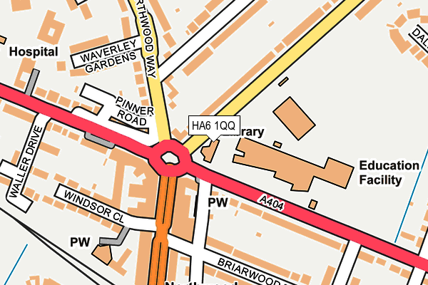
HA6 1QQ is located in the Northwood Hills electoral ward, within the London borough of Hillingdon and the English Parliamentary constituency of Ruislip, Northwood and Pinner. The Sub Integrated Care Board (ICB) Location is NHS North West London ICB - W2U3Z and the police force is Metropolitan Police. This postcode has been in use since January 1980.


GetTheData
Source: OS OpenMap – Local (Ordnance Survey)
Source: OS VectorMap District (Ordnance Survey)
Licence: Open Government Licence (requires attribution)
| Easting | 510332 |
| Northing | 190528 |
| Latitude | 51.602794 |
| Longitude | -0.408303 |
GetTheData
Source: Open Postcode Geo
Licence: Open Government Licence
| Country | England |
| Postcode District | HA6 |
➜ See where HA6 is on a map ➜ Where is Ruislip? | |
GetTheData
Source: Land Registry Price Paid Data
Licence: Open Government Licence
Elevation or altitude of HA6 1QQ as distance above sea level:
| Metres | Feet | |
|---|---|---|
| Elevation | 70m | 230ft |
Elevation is measured from the approximate centre of the postcode, to the nearest point on an OS contour line from OS Terrain 50, which has contour spacing of ten vertical metres.
➜ How high above sea level am I? Find the elevation of your current position using your device's GPS.
GetTheData
Source: Open Postcode Elevation
Licence: Open Government Licence
| Ward | Northwood Hills |
| Constituency | Ruislip, Northwood And Pinner |
GetTheData
Source: ONS Postcode Database
Licence: Open Government Licence
| Northwood School | Northwood Hills | 31m |
| Northwood School (Pinner Road) | Northwood Hills | 57m |
| Stanley Road (Ha6) (Northwood Way) | Northwood Hills | 85m |
| Northwood School | Northwood Hills | 92m |
| Northwood Hills Circus (Joel Street) | Northwood Hills | 107m |
| Northwood Hills Underground Station | Northwood Hills | 260m |
| Northwood Underground Station | Northwood | 1,414m |
| Haste Hill (Ruislip Lido Railway) (Ruislip Lido) | Ruislip Common | 1,594m |
| Hatch End Station | 2.8km |
| Carpenders Park Station | 3.2km |
| Headstone Lane Station | 3.5km |
GetTheData
Source: NaPTAN
Licence: Open Government Licence
GetTheData
Source: ONS Postcode Database
Licence: Open Government Licence


➜ Get more ratings from the Food Standards Agency
GetTheData
Source: Food Standards Agency
Licence: FSA terms & conditions
| Last Collection | |||
|---|---|---|---|
| Location | Mon-Fri | Sat | Distance |
| Northwood Delivery Office | 17:30 | 12:00 | 297m |
| Alandale Drive | 18:00 | 13:15 | 324m |
| Northwood Hills Post Office | 18:15 | 12:15 | 335m |
GetTheData
Source: Dracos
Licence: Creative Commons Attribution-ShareAlike
The below table lists the International Territorial Level (ITL) codes (formerly Nomenclature of Territorial Units for Statistics (NUTS) codes) and Local Administrative Units (LAU) codes for HA6 1QQ:
| ITL 1 Code | Name |
|---|---|
| TLI | London |
| ITL 2 Code | Name |
| TLI7 | Outer London - West and North West |
| ITL 3 Code | Name |
| TLI74 | Harrow and Hillingdon |
| LAU 1 Code | Name |
| E09000017 | Hillingdon |
GetTheData
Source: ONS Postcode Directory
Licence: Open Government Licence
The below table lists the Census Output Area (OA), Lower Layer Super Output Area (LSOA), and Middle Layer Super Output Area (MSOA) for HA6 1QQ:
| Code | Name | |
|---|---|---|
| OA | E00012371 | |
| LSOA | E01002483 | Hillingdon 002D |
| MSOA | E02000495 | Hillingdon 002 |
GetTheData
Source: ONS Postcode Directory
Licence: Open Government Licence
| HA6 1BZ | Pinner Road | 57m |
| HA6 1DD | Pinner Road | 63m |
| HA6 1QL | Pinner Road | 82m |
| HA6 1RA | Northwood Way | 92m |
| HA6 1NU | The Broadway | 106m |
| HA6 1PG | Oakdale Avenue | 106m |
| HA6 1PF | The Broadway | 111m |
| HA6 1QJ | Potter Street | 113m |
| HA6 1RB | Northwood Way | 137m |
| HA6 1QN | Pinner Road | 141m |
GetTheData
Source: Open Postcode Geo; Land Registry Price Paid Data
Licence: Open Government Licence